
Tornado Outbreak Likely This Evening Across Eastern Nebraska, Western Iowa, Southwestern Minnesota and Northern Kansas With Strong to Violent Tornadoes Possible 4 to 10 PM Including Omaha and Sioux City
OMAHA, Nebraska – A localized tornado outbreak is likely this evening across eastern Nebraska, western Iowa, southwestern Minnesota and northern Kansas between 4:00 and 10:00 PM, with strong to violent tornadoes possible across a corridor from Omaha through Sioux City. Damaging winds and large hail will also be major threats with all storms this evening. Have multiple ways to receive weather alerts right now.
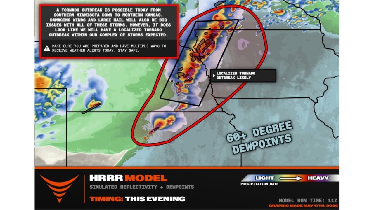
Tornado Outbreak Is Likely Tonight
Forecasters are now stating a localized tornado outbreak is likely within the complex of storms expected this evening. This is not a watch-and-wait situation. A tornado outbreak means multiple tornadoes are expected across a concentrated area during a defined time window. The primary target corridor runs from southern Minnesota down through northern Kansas, with the bull’s eye centered on eastern Nebraska and western Iowa including Omaha through Sioux City during the 4:00 to 10:00 PM window tonight, Sunday, May 17.
Three Major Threats This Evening
Every storm firing tonight carries three life-threatening hazards:
- Strong to violent tornadoes are the headline threat from 4:00 to 10:00 PM across eastern Nebraska, western Iowa, southwestern Minnesota and northern Kansas. Violent tornadoes are capable of EF4 to EF5 level destruction and can stay on the ground for extended distances.
- Damaging winds will be a major issue with all storms tonight, capable of widespread destruction well beyond any individual tornado track across the entire outbreak zone.
- Large hail will accompany the strongest supercells firing this evening, posing serious risk to vehicles, roofs and anyone caught outdoors across eastern Nebraska, western Iowa and northern Kansas.
Western Oklahoma Also Under the Gun Tonight
Forecasters are specifically extending the severe weather watch corridor down through western Oklahoma tonight. Residents across western Oklahoma should stay tuned to severe weather watches and warnings through the evening hours in addition to the primary outbreak zone to the north.
What 60 Degree Plus Dewpoints Mean for Tonight
Dewpoints of 60 degrees or higher are surging across the threat area tonight, shown across the eastern portions of the map. This level of atmospheric moisture is the fuel that makes supercell thunderstorms explosive and capable of producing violent tornadoes. 60 degree plus dewpoints combined with the wind energy in place tonight across eastern Nebraska and western Iowa create one of the most dangerous tornado environments possible.
You Have a Very Short Window to Act Right Now
The 4:00 PM storm initiation time is approaching. If you are in eastern Nebraska, western Iowa, southwestern Minnesota or northern Kansas and you have not yet identified your tornado shelter, do it right now. Go to the lowest interior room of a sturdy building. Stay away from windows. Do not attempt to drive away from a tornado tonight. Violent tornadoes can move faster than a vehicle can escape and can be completely invisible inside rain-wrapped supercells after dark.
WaldronNews.com will continue tracking this tornado outbreak threat across eastern Nebraska, western Iowa, southwestern Minnesota and northern Kansas and will provide updates as tornado warnings, violent tornado reports and storm damage emerge between 4:00 and 10:00 PM Sunday, May 17.