
Nebraska, Kansas, Iowa and Wisconsin Face 45% Tornado Probability and EF2 Plus Tornado Threat Monday May 18 Through Tuesday Morning May 19
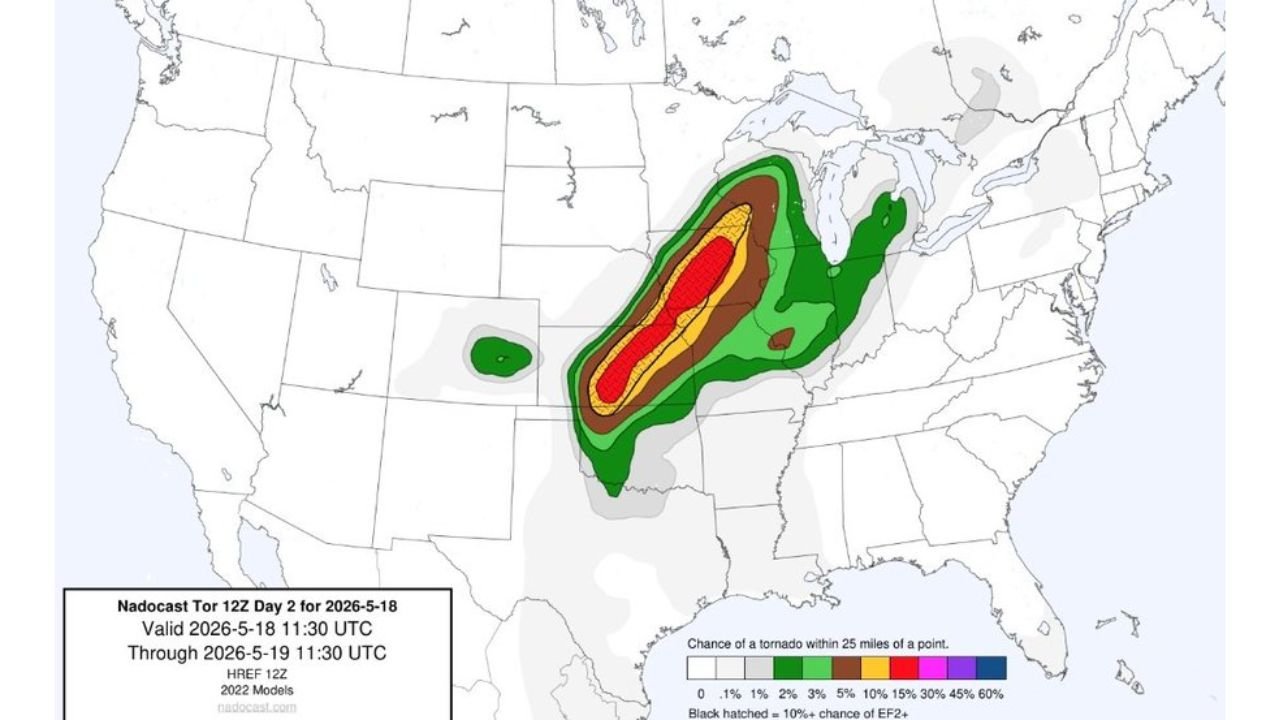
OMAHA, Nebraska – An aggressive tornado probability forecast valid from Monday, May 18 through Tuesday morning, May 19 is showing a 45% chance of a tornado within 25 miles of a point across the core risk zone, with a 10% or greater chance of an EF2 or stronger tornado hatched across a significant corridor through the Plains and Upper Midwest. This is one of the most alarming tornado probability maps seen this season for Monday, May 18.
What the Tornado Probability Colors Mean
The tornado probability map for Monday, May 18 shows the chance of a tornado occurring within 25 miles of any given point:
- 45% probability shown in the innermost red and pink hatched zone covers the core outbreak corridor and represents the highest tornado likelihood on the map Monday.
- 30% probability shown in orange surrounds the highest-risk core and still represents a very high likelihood of tornado activity within 25 miles of communities in this zone.
- 15% probability shown in yellow covers a broader area extending the tornado threat into the Plains and Great Lakes region Monday.
- 10% probability shown in brown marks the outer edge of the meaningful tornado threat zone through Tuesday morning, May 19.
- Black hatching overlaid on the map indicates a 10% or greater chance of an EF2 or stronger tornado within 25 miles of a point, covering a significant portion of the highest-risk corridor Monday.
Two Separate Risk Areas Monday May 18
Both forecast maps show two distinct tornado probability clusters for Monday, May 18:
- The primary risk zone stretches northeast to southwest through the central Plains and into the Upper Midwest and Great Lakes region, where the 45% tornado probability and EF2 or stronger hatching are concentrated. This is the main outbreak corridor for Monday, May 18.
- A secondary smaller risk area is visible further west, showing a separate 5% or greater tornado probability cluster that residents in that region should also monitor heading into Monday.
The EF2 or Stronger Hatching Is the Critical Signal
The black hatching showing a 10% or greater chance of an EF2 or stronger tornado is the most important detail on this map. A 10% probability of a violent tornado within 25 miles of your location means that in roughly 1 out of every 10 similar setups, a community in that zone experiences an EF2 or stronger tornado. An EF2 carries winds of 111 to 135 mph while EF3, EF4 and EF5 tornadoes escalate to winds exceeding 200 mph. The black hatching across the Plains and Upper Midwest for Monday, May 18 represents a life-threatening tornado risk.
This Is the Aggressive Side of the Forecast
Forecasters note this represents the more aggressive end of available forecast solutions for Monday, May 18. However, with a 45% tornado probability and EF2 or stronger hatching showing in the core zone, the minimum expected outcome for Monday remains a significant and dangerous tornado event. Do not wait for the most favorable scenario to materialize before taking this threat seriously.
What You Must Do Before Monday Morning
Anyone across the Plains and Upper Midwest within the tornado probability zones must complete all severe weather preparations before Monday morning, May 18. Identify your tornado shelter now. Charge all devices tonight. Keep weather alerts active on your phone all day Monday. The 45% tornado probability zone represents one of the most dangerous forecast signals seen this season. Treat Monday, May 18 as a potentially life-threatening weather day.
WaldronNews.com will continue tracking this 45% tornado probability outbreak threat across Nebraska, Kansas, Iowa and Wisconsin and will provide updates as the EF2 or stronger tornado risk develops for Monday, May 18 through Tuesday morning, May 19.