
Alabama and Mississippi Face Severe Storms Thursday and Friday Before 1 to 2 Inches of Rain Threatens Talladega NASCAR Race Weekend
BIRMINGHAM, Alabama — A significant and multi-day severe weather and rain event is building for Alabama and Mississippi this week — and the timing could not be more complicated. Severe thunderstorm risks are already formally posted for Thursday April 23 and Friday April 24 across states west of Alabama, with that threat pushing directly into Alabama and Mississippi by the weekend. And for the 100,000+ NASCAR fans heading to Talladega Superspeedway this weekend, the forecast is carrying 1 to 2 inches of rain across northern Alabama with showers and thunderstorms possible both Saturday and Sunday.
The 7-day precipitation map through Sunday April 26 tells the full story — deep purple and red covering Arkansas, Tennessee, and Mississippi with totals of 1.6 to 2.8 inches across the region, and 1.0 to 1.6 inches spreading across central and northern Alabama including the Talladega corridor. This is not a minor passing shower event — this is a multi-day active weather pattern with severe weather potential attached.
States and Areas in the Week’s Threat Window
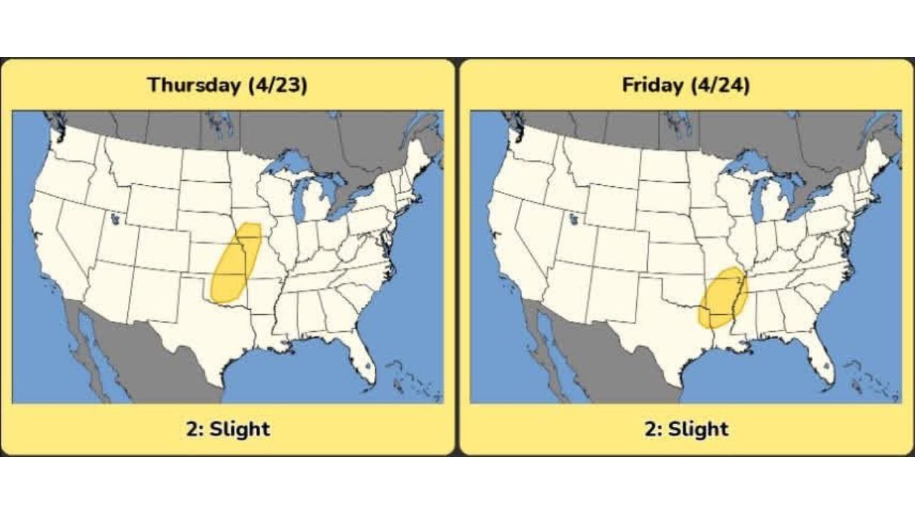
- Kansas and Oklahoma: Slight Risk already formally posted for Thursday April 23 — the first firing of this week’s storm system along the dryline
- Mississippi: Slight Risk Friday April 24 — the storm system shifts southeast and targets Mississippi directly with severe thunderstorm potential
- Alabama: Talladega, Birmingham, Huntsville — watching severe weather potential Thursday and Friday from systems to the west, then rain impacts Saturday and Sunday during NASCAR race weekend
- Arkansas: Little Rock, Fort Smith — inside the 1.6 to 2.3 inch precipitation zone for the 7-day period
- Tennessee: Memphis, Nashville — deep purple on the precipitation map with 1.6 to 2.5 inches expected through Sunday
- Mississippi: Jackson, Tupelo — Slight Risk Friday with 1.5 to 1.6 inches of total rainfall through the week
The Thursday and Friday Severe Weather Setup
The severe weather threat this week follows a now-familiar two-day progression — Plains fires first, Southeast follows.
Thursday April 23 — A Slight Risk of severe weather is posted across Kansas, Oklahoma, and into Missouri and Illinois as the dryline sharpens and storm initiation begins across the Southern Plains. This is the same setup that has been highlighted all week with tornado potential along the cold front-dryline interaction zone.
Friday April 24 — The storm system shifts southeast and the Slight Risk zone drops directly over Mississippi — putting Jackson, Hattiesburg, Meridian, and Tupelo in the formal severe weather probability area. Damaging winds, large hail, and isolated tornadoes are all possible with any organized supercells that fire across Mississippi Friday.
Alabama sits just east of the Friday Slight Risk boundary — meaning communities across central and northern Alabama including Birmingham, Huntsville, and Tuscaloosa are watching closely whether the threat expands eastward as the system tracks through.
The Talladega NASCAR Race Weekend Forecast
This is the specific forecast that tens of thousands of race fans are asking about right now.
Talladega Superspeedway sits in Talladega County in north-central Alabama — directly inside the 1.0 inch precipitation zone on the 7-day map. The broader northern Alabama corridor picks up 1.0 to 1.6 inches of total rainfall through Sunday — and that rain is spread across both race weekend days.
- Saturday — showers and thunderstorms possible across Alabama — not a washout but rain chances are real throughout the day with potential for lightning delays to any outdoor activities at the speedway
- Sunday — additional shower and thunderstorm chances lingering across northern Alabama — the race day forecast carries continued uncertainty with timing of dry windows still to be determined
- Severe weather — too early to confirm whether severe thunderstorms will be a concern specifically over Talladega during the weekend — the severe threat is currently focused Thursday and Friday to the west, but whether it extends into Alabama over the weekend is still being evaluated
- Rain totals — 1 to 2 inches across northern Alabama through the weekend period — enough to create muddy infield conditions, wet grandstands, and potential lightning delays
Race fans heading to Talladega this weekend should plan for wet conditions, bring rain gear, and monitor the forecast closely through Wednesday and Thursday when the weekend timing will become much clearer.
The 7-Day Rainfall Picture Across the Region
The precipitation map through Sunday April 26 is welcome news for a region that has been locked in drought — but it also signals the active severe weather pattern that comes with Gulf moisture returning.
- Arkansas: Deep red cores showing 2.3 to 2.8 inches across central and northern Arkansas — significant drought relief for a state that has been running well below normal
- Tennessee: 1.6 to 2.5 inches across the state through Sunday — Memphis picking up some of the highest totals in the western part of the state
- Mississippi: 1.5 to 1.6 inches across most of the state — meaningful improvement for communities that have been parched through early spring
- Alabama: 0.8 to 1.6 inches across northern and central Alabama — Talladega, Birmingham, and Huntsville all in this range
- South Alabama and Florida: Much lighter totals of 0.1 to 0.5 inches — the rain shield does not extend strongly into the southern portion of the state
What Alabama and Mississippi Residents Should Do This Week
- Thursday and Friday — watch the severe weather progression carefully as the system moves from Kansas-Oklahoma eastward toward Mississippi — warnings could be issued across Mississippi Friday and potentially into Alabama Friday evening
- Talladega race fans — monitor the forecast daily through Thursday for updated rain and severe weather timing — pack rain gear and know the speedway’s lightning delay procedures before arriving
- Northern Alabama communities — 1 to 2 inches of rain arriving on drought-stressed soils can run off quickly — watch for localized flooding particularly in areas with hard-packed ground
- Mississippi residents — Friday’s Slight Risk is a formal severe weather designation — have shelter plans ready before Friday afternoon storms develop
- Plan for the full week — this is not a one-day event but a multi-day active pattern running from Thursday through Sunday across the Deep South
Alabama and Mississippi are entering the most active weather week of the spring with severe storms Thursday and Friday, followed by a potentially rain-disrupted Talladega NASCAR weekend. Stay informed and prepared through every day of this stretch.
WaldronNews.com will continue tracking this week’s severe weather threat and the Talladega race weekend forecast across Alabama and Mississippi and provide daily updates as the pattern evolves.