
Georgia, Alabama, Tennessee and Mississippi Finally Getting 2 to 4 Inches of Rain Late April as Pattern Change Targets Severe Drought Through May 4
ATLANTA, Georgia — The drought that has been suffocating Georgia, Alabama, Tennessee, and Mississippi through March and April is finally about to get some relief. A significant pattern change is building for the Southeastern United States in late April into early May — bringing multiple rounds of rain and storms and the best drought relief signal the region has seen all spring, with total rainfall accumulations of 2 to 4 inches possible across the hardest-hit drought areas through Monday May 4.
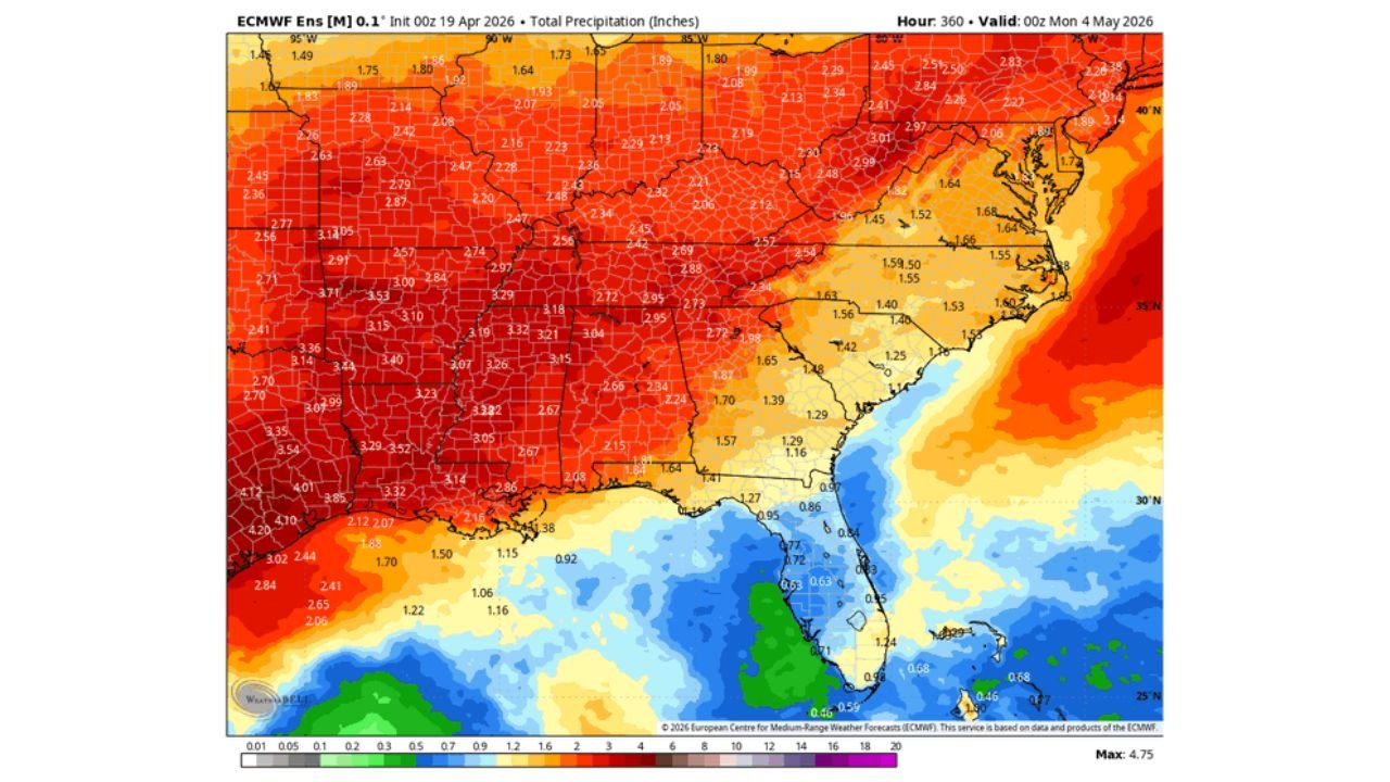
Three separate data sets are all telling the same story — above normal precipitation is coming to the Southeast and it arrives right when the region needs it most. The 6 to 10 day precipitation probability outlook shows above normal precipitation covering virtually the entire Eastern United States from April 24 through April 28. The ensemble total precipitation map through May 4 shows 2.5 to 4.0 inches across Arkansas, Tennessee, Mississippi, and Alabama. And the 7-day anomaly map confirms rainfall running 1.5 to 2.09 inches above normal across the core drought zone.
States Getting the Most Relief
- Arkansas: Little Rock, Fort Smith, Texarkana — 3.5 to 4.10 inches total precipitation through May 4 — the deepest drought relief totals on the entire map with anomalies running 2.01 inches above normal
- Mississippi: Jackson, Tupelo, Hattiesburg — 2.86 to 3.52 inches total through May 4 — significant improvement for one of the most drought-stressed states in the region
- Tennessee: Memphis, Nashville, Chattanooga — 2.72 to 3.21 inches of total rainfall — the best sustained rainfall event Tennessee has seen since early spring
- Alabama: Birmingham, Huntsville, Tuscaloosa — 2.67 to 3.18 inches total — meaningful drought relief arriving just in time for critical spring agricultural needs
- Georgia: Atlanta, Columbus, Macon — 2.19 to 2.72 inches through May 4 — above normal precipitation helping to ease the severe to extreme drought that has been expanding across the state
- Louisiana: Northern Louisiana picking up 2.07 to 2.84 inches — Gulf Coast communities see lighter totals as the moisture shield is focused further north
- Kentucky: Louisville, Bowling Green — 2.05 to 2.48 inches of above normal rainfall through the period
- Virginia and North Carolina: 1.42 to 1.68 inches on the eastern edge of the precipitation shield — helpful but less dramatic than the core Southeast totals
- Texas: Eastern Texas picking up 0.92 to 1.42 inches — lighter totals on the western fringe of the moisture return
What Is Driving This Pattern Change
The subtropical flow returning from the Gulf of Mexico is the engine behind the late April pattern change. After weeks of the blocking high keeping Gulf moisture suppressed and temperatures elevated across the Southeast, that blocking pattern is finally breaking down.
As it does, a stronger subtropical moisture pipeline develops — funneling warm and humid Gulf air northward into Alabama, Mississippi, Tennessee, and Georgia repeatedly through the last week of April and into early May. Each time a storm system drops out of the Plains or Rockies and interacts with that Gulf moisture, another round of rain and storms fires across the Southeast.
The 6 to 10 day precipitation probability map shows the entire Eastern United States — except the Pacific Northwest which stays dry — covered in above normal precipitation probability for the April 24 through April 28 window. The green shading covers everything from Texas to Maine — but the deepest and most consistent signal is concentrated over the Deep South and Mid-South where the drought has been most severe.
Above Normal But Not a Complete Drought Buster
The honest assessment from forecasters is important — this pattern change will bring meaningful relief to the severe to extreme drought conditions across the Southeast, but it will likely not fully break the drought for most areas.
The anomaly map tells this story precisely. The blue zone — representing the most above-normal rainfall — is concentrated over central Arkansas and northern Mississippi where anomalies reach 2.01 to 2.09 inches above normal. Across Alabama and Georgia, anomalies run 0.74 to 1.47 inches above normal — significant improvement but not enough to erase a moisture deficit that has been building since early March.
Severe drought typically requires 4 to 6 inches above normal over an extended period to fully recover. What is coming late April delivers 1 to 2 inches above normal across most of the region — a first meaningful step toward recovery, not a complete solution.
The Severe Weather Component
The same subtropical moisture return that brings drought relief also brings severe weather potential. Every time warm Gulf moisture surges northward and encounters storm systems dropping out of the Plains, the atmosphere becomes capable of producing severe thunderstorms across the Southeast.
The Slight Risk already formally posted for Mississippi on Friday April 24 is the first formal indicator of this. The broader setup for Saturday April 25 — with 30% tornado probability already showing for the Alabama-Mississippi corridor — represents the peak severe weather concern embedded within this beneficial rain pattern.
Georgia, Alabama, Tennessee, and Mississippi residents need to hold both realities simultaneously — this pattern brings needed rain AND potential severe weather. The drought relief and the storm threat arrive in the same atmospheric package.
What to Watch Through May 4
- April 24 Friday — severe weather possible across Mississippi as the first storm system fires — watch for tornado watches
- April 25 Saturday — the peak severe weather day for Alabama and Mississippi with 30% tornado probability already posted
- April 26 through April 28 — continued rounds of rain and storms as the subtropical flow strengthens and multiple disturbances ride the active pattern
- Drought monitor improvements — the next several weekly Drought Monitor updates will show gradual improvement across Alabama, Georgia, Tennessee, and Mississippi as rainfall accumulates
- Flash flooding watch — drought-hardened soils across the region absorb water slowly, meaning 2 to 4 inch totals arriving in multiple rounds could produce localized flash flooding even without extreme rainfall rates
- Agricultural impact — farmers across the Southeast should monitor soil moisture recovery carefully and adjust planting schedules as conditions improve through early May
The Southeast has been waiting weeks for this pattern change. It is finally arriving — with both the relief of rainfall and the responsibility of severe weather awareness coming together in the same late April window.
WaldronNews.com will continue tracking the developing precipitation pattern and severe weather threat across Georgia, Alabama, Tennessee and Mississippi through early May and provide daily updates as the pattern evolves.