
Oklahoma, Kansas and Wisconsin Brace for Tornadoes Large Hail and Damaging Winds Thursday as Powerful Storm Targets the Plains and Midwest
KANSAS CITY, Missouri — A powerful storm system is taking shape for Thursday April 24 and the threat it carries is serious — tornadoes, large hail, and damaging winds are all possible from Oklahoma all the way north to Wisconsin as the next major severe weather setup of the spring arrives just days after the historic April 17 outbreak that devastated the Upper Midwest.
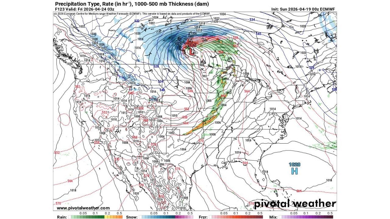
The forecast map valid Friday April 24 shows a deep and well-organized low pressure system — central pressure near 985 to 992 hPa — diving into the Central Plains with a sharp cold front and warm sector stretching from Wisconsin south through Illinois, Missouri, Kansas, and into Oklahoma. Green and yellow precipitation signatures mark the active severe weather zone along the warm front and cold front boundaries — the exact locations where supercells and tornado-producing storms develop in spring outbreak setups.
The good news — and it is genuine good news — is that Monday through Wednesday stays quiet. Communities still recovering from April 17 damage across Wisconsin, Iowa, and Illinois have a real window to assess, repair, and prepare before Thursday’s threat arrives.
States and Cities in Thursday’s Threat Zone
- Oklahoma: Oklahoma City, Tulsa, Woodward, Enid — in the southern portion of the severe weather corridor where supercells can fire along the dryline through Thursday afternoon
- Kansas: Wichita, Dodge City, Kansas City — inside the primary threat zone as the low pressure center drops into the Central Plains
- Missouri: Kansas City, St. Louis, Springfield — watching the warm front and cold front interaction push through Thursday
- Iowa: Des Moines, Davenport — on the northern edge of the severe weather corridor as the system tracks northeast
- Illinois: Chicago, Rockford, Peoria — watching Thursday’s system push through from the southwest with severe weather possible through the afternoon and evening
- Wisconsin: Milwaukee, Madison — on the far northern end of the threat corridor from Oklahoma to Wisconsin — the same communities that dealt with EF3 tornadoes just one week ago
What Thursday’s Storm System Is Bringing
The precipitation type map valid Thursday April 24 tells the full story of this system’s scope and organization.
- Deep low pressure near 985 to 992 hPa dropping into the Central Plains — a powerful and well-organized storm system providing the lift and upper-level support needed to fire severe weather across multiple states
- Warm sector precipitation — green and yellow rain signatures marking the active severe weather zone stretching from Oklahoma northeast through Kansas, Missouri, Iowa, and Illinois
- Sharp cold front — the boundary where the most intense storm development occurs as cold air crashes into the deeply unstable warm sector air ahead of it
- Snow on the northwestern side — blue precipitation signatures over the northern Plains and upper Midwest confirming the cold air mass depth on the back side of this system
- Tornadoes — explicitly mentioned in the threat description from Oklahoma to Wisconsin — the entire corridor needs to be on alert Thursday
- Large hail — supercells firing along the dryline and warm front will produce hail threats across the entire Plains and Midwest corridor
- Damaging winds — both from discrete supercells and the squall line that follows — 60 to 70 mph gusts possible across a wide footprint Thursday
Why Thursday Demands Full Respect After Last Week
The April 17 outbreak that confirmed two EF3 tornadoes in Wisconsin, generated 150 tornado warnings, and produced 40+ confirmed tornadoes across six states was powered by the same basic atmospheric ingredients that are setting up again for Thursday — a powerful low pressure system, a sharp cold front, Gulf moisture in the warm sector, and significant wind shear aloft.
The fact that Wisconsin and Illinois — communities still actively surveying damage from just one week ago — are again inside Thursday’s threat corridor is a sobering reminder of how relentless the 2026 spring severe weather season has been.
Oklahoma and Kansas are the initiation zone Thursday as the dryline sharpens during the afternoon heating hours. Missouri and Iowa receive the mid-day push. Illinois and Wisconsin get the late afternoon and evening chapter — repeating a now-familiar northwest-to-southeast storm track that defined last Friday’s outbreak.
The Quiet Window Before Thursday
Monday through Wednesday — three full days of quiet weather across the Plains and Midwest before Thursday’s system arrives. This window is valuable and should be used deliberately by communities still in recovery mode.
Wisconsin EF3 damage areas — three days to complete structural assessments, document remaining damage, and clear debris before the next severe weather threat arrives. Illinois tornado survey areas — three days for survey teams to complete damage mapping across McLean County and beyond. Indiana and Iowa communities — three days to finish insurance documentation and begin repairs before another round demands full weather attention.
The quiet window is not a sign that the season is calming down. It is a brief pause before another significant system demands the same level of preparation and awareness that April 17 required.
What to Do Before Thursday Arrives
- Oklahoma City, Tulsa, and Wichita — you are in the first firing zone Thursday afternoon, have shelter plans confirmed before Wednesday night
- Kansas City and St. Louis — the warm front and cold front interaction zone passes directly through your communities Thursday — keep weather alerts active all day
- Des Moines and Chicago — Thursday evening is your primary threat window as the system tracks northeast through the afternoon
- Wisconsin residents still dealing with April 17 damage — be aware that Thursday brings another severe weather threat to your state — prioritize shelter preparation alongside ongoing recovery efforts
- Use Monday through Wednesday — review your emergency plan, recharge weather radio batteries, confirm your shelter location, and monitor forecast updates daily as Thursday approaches
- Watch for tornado watches issued Wednesday night or Thursday morning — formal watches will be the clearest signal that the severe window is opening across the Plains and Midwest
The atmosphere across the Central United States does not rest long between major setups this spring. Thursday April 24 is the next date that demands full attention from Oklahoma to Wisconsin.
WaldronNews.com will continue tracking Thursday’s developing severe weather threat across the Plains and Midwest and provide daily updates as the system approaches through the week.