
Arkansas, Tennessee, Mississippi and Alabama Face One More Dry Week Before Major Pattern Shift Brings Severe Storms and Below Normal Temperatures Late April Into May
LITTLE ROCK, Arkansas — One more week. That is the message for the Southeast right now — one more week of little to no rain before a significant and long-awaited pattern change arrives late April into early May, bringing multiple rounds of rain and storms, below normal temperatures, and a genuine severe weather threat that could affect communities from the South Central United States all the way into the Deep South.
Four separate data sets are all pointing to the same story — the dry and warm pattern that has dominated Arkansas, Tennessee, Mississippi, and Alabama through most of April is about to be replaced by a dramatically different and more active atmospheric setup beginning around April 24 through 25 and continuing through at least the first days of May.
The Full Scope of What Is Coming Late April
The atmospheric setup building for late April is complex and multi-layered — and every piece of it is now showing up consistently across the data.
The deep trough — the 500 mb height anomaly map valid April 28 through May 3 shows one of the most striking patterns of the spring season. A massive blue anomaly zone — representing heights well below normal indicating a deep cold trough — is locked over the entire Central and Eastern United States. From the Great Plains east through Ohio, Tennessee, and into the Mid-Atlantic, the atmosphere is running 54 to 87 meters below normal at the mid-levels. That is an extraordinarily deep trough for late April — and it is the engine that drives everything else in this pattern.
The southern jet stream — the 200 hPa wind speed map valid Saturday May 2 shows a powerful southern jet stream screaming across the Gulf Coast states and Southeast at speeds exceeding 90 to 120 knots. The green shading covering Texas, Oklahoma, Arkansas, Tennessee, Alabama, and Mississippi marks this jet corridor precisely — and a strong southern jet means upper-level support for storm development is maximized directly over the drought-stricken Southeast. This is the atmospheric feature that forecasters describe when they say “kinematics will be in place” — the wind shear needed to organize severe weather is arriving in force.
The temperature crash — the 2-meter temperature anomaly map valid April 28 through May 3 confirms what the trough pattern implies. The entire Central and Eastern United States — from Kansas and Nebraska through Illinois, Indiana, Ohio, and into the Mid-Atlantic — is running 9 to 18 degrees below normal on temperatures during this period. Arkansas, Tennessee, Mississippi, and Alabama sit on the southern edge of the cold anomaly, meaning temperatures will feel noticeably cooler than the recent heat — a dramatic contrast from the 80 and 90 degree readings the region has seen through most of April.
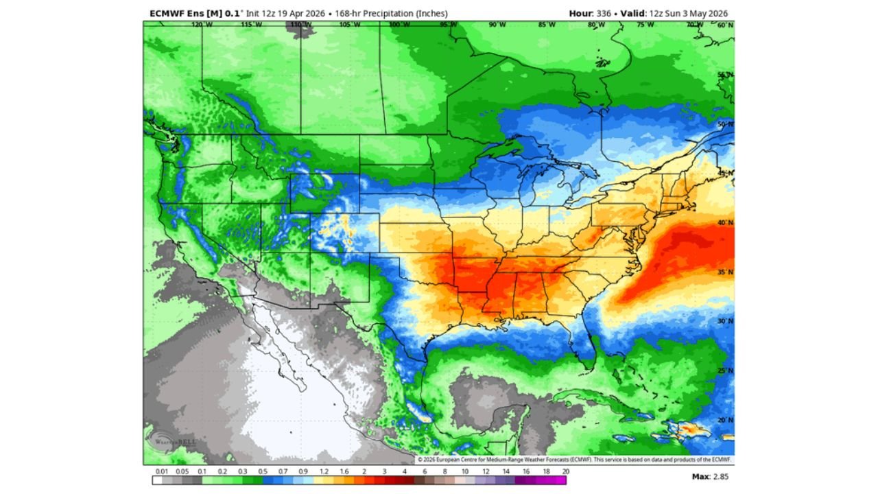
The precipitation delivery — the 168-hour precipitation map through Sunday May 3 shows the rain bullseye sitting directly over Arkansas, Tennessee, Mississippi, and Alabama — deep orange and red colors indicating 1.5 to 2.85 inches of rainfall over the final week of April and first days of May. The Southeast corridor from Little Rock through Memphis, Nashville, Birmingham, and Jackson is painted in the warmest precipitation colors on the map — confirming this region receives the heaviest and most sustained rainfall of the entire pattern change.
The Sequence of Events This Week Through May
Monday through Wednesday April 21 to 23 — quiet and mostly dry across the Southeast. The last remnants of the current dry pattern hold as the trough begins digging westward. This is the final preparation window before the active pattern takes over.
Thursday April 24 — the trough digs in from the west and severe weather fires across the Central Plains — Oklahoma, Kansas, Missouri — as the first storm system of the new pattern initiates. Tornadoes, large hail, and damaging winds are possible from Oklahoma to Wisconsin on Thursday.
Friday April 25 through Saturday April 26 — ingredients shift southeast. The severe weather threat moves into the South Central United States and then the Deep South — Arkansas, Mississippi, Alabama, and Tennessee face their own severe weather window as Gulf moisture surges northward beneath the strengthening southern jet. This is the 30% tornado probability window already formally highlighted for Alabama and Mississippi.
Late April 27 through early May — the deep trough anchors itself over the Central to Eastern United States and a transition occurs. The pattern becomes more progressive with frequent rounds of rain and storms moving through the Southeast under the influence of the deepening trough and strengthening southern jet. A strong storm system is possible as this transition fully locks in around late April 28 into early May.
May 1 through May 3 — the active pattern continues with below normal temperatures, frequent storm chances, and the southern jet maintaining upper-level support for organized storm development across the Deep South.
What This Means for the Drought
The Southeast has been in severe to extreme drought conditions through most of March and April. The pattern change arriving late April will not erase that deficit entirely — but it represents the most significant and sustained moisture return the region has seen this spring.
The 168-hour precipitation map showing 1.5 to 2.85 inches across the Arkansas to Alabama corridor through May 3 — combined with the above normal precipitation probability already showing for the entire Eastern United States in the 6 to 10 day outlook — means the drought recovery process genuinely begins in the last week of April.
Arkansas receives the heaviest totals on the precipitation map — the deep red values centered over the state confirming it as the maximum precipitation zone for this event. Tennessee and Mississippi sit in the orange zone. Alabama and Georgia receive meaningful but slightly lighter totals on the eastern edge of the precipitation shield.
Why Severe Weather Comes With This Relief
The same atmospheric ingredients that deliver drought-breaking rainfall also create severe weather potential. The deep trough brings cold air aloft while Gulf moisture streams northward at the surface — creating extreme instability when the two airmasses interact. The powerful southern jet stream provides the wind shear needed to organize that instability into supercells and tornado-producing storms.
This is the fundamental paradox of Southeast spring weather — the same pattern change that brings desperately needed rain also brings the most dangerous severe weather conditions of the season. The 30% tornado probability for Alabama and Mississippi on April 25 and the broad severe weather threat from Thursday onward are not separate from the drought relief story — they are the same atmospheric story told from different perspectives.
What Every State in This Corridor Should Do Right Now
- Arkansas, Tennessee, Mississippi, and Alabama — use Monday through Wednesday to prepare for what arrives Thursday onward — review emergency plans, confirm shelter locations, and monitor daily forecast updates
- Thursday April 24 — the first severe weather day targets Oklahoma, Kansas, and the Plains — watch how this system develops as a preview of what follows Friday and Saturday for the Southeast
- Friday April 25 and Saturday April 26 — the peak severe weather window for Alabama and Mississippi — be fully prepared before Thursday evening
- Below normal temperatures arriving late April — after weeks of heat, the temperature crash accompanying this pattern change will feel dramatic — have layers ready and protect any warm-season garden plants from potential late cold snaps
- Flash flooding awareness — drought-hardened soils across the Southeast will not absorb 2 to 3 inch rainfall events quickly — localized flash flooding is a real parallel threat alongside severe storms
- Monitor through early May — this is not a single-day event but a sustained multi-day active weather pattern that runs from Thursday April 24 through at least May 3
One more quiet week — then the most significant atmospheric pattern change of the spring arrives across the Southeast. The drought relief, the severe weather threat, and the temperature crash all come together in the same late April window.
WaldronNews.com will continue tracking the developing late April pattern change across Arkansas, Tennessee, Mississippi, Alabama and the broader Southeast and provide daily updates through the active weather period ahead.