
Arkansas and Mississippi Face Significant Tornado Threat Wednesday as Supercell Composite of 11.2 and Updraft Helicity Ensemble Signal a High-End All-Hazards Event
LITTLE ROCK, Arkansas — Every major atmospheric data source is now pointing to Wednesday, May 6, 2026 as a significant and potentially dangerous severe weather day across Arkansas and Mississippi, with a cutoff low pressure system over the southwestern United States phasing with an eastern jet stream to concentrate extreme wind shear directly over the region. The combination of a Supercell Composite of 11.2, Storm-Relative Helicity of 864 m²/s², STP of 2.4 and ensemble updraft helicity signals reaching into the 99th percentile over Arkansas and Mississippi is not a marginal setup. This is a high-end all-hazards threat with significant tornadoes explicitly on the table.
What the Upper-Level Pattern Is Doing
A cutoff low anchored over the southwestern United States has been a recurring and frustrating pattern through 2026, but on Wednesday its left exit region swings directly over Arkansas and Mississippi, providing the upper-level divergence and jet stream energy needed to support explosive storm development.
The 500 mb ensemble mean shows two distinct jet stream branches, one across the Gulf of Mexico running yellow to orange shading indicating 80 to 110+ knot winds, and a northern branch across the central United States. These two jets are phasing over the Arkansas-Mississippi corridor, concentrating their combined energy into a single powerful system directly above the highest moisture and instability zone.
Surface Moisture Feeding the Threat
The ensemble mean dewpoint map valid Wednesday, May 6 at 00z shows 60 to 65 degree dewpoints surging across Arkansas, Mississippi and Louisiana ahead of the approaching surface boundary. The moisture gradient is sharp, with dry air still in place across Texas and Oklahoma to the west while the humid Gulf air is well established to the east. That sharp moisture boundary, combined with the phasing jets overhead, creates the ideal trigger zone for discrete supercell development across Arkansas into Mississippi.
What the Sounding Data Shows
A sounding valid Wednesday May 6 at 00z over 35.27°N, 92.22°W in central Arkansas reveals one of the more dangerous profiles seen in this region this spring:
- Surface CAPE: 864 J/kg, forecast CAPE rising to 2,163 J/kg with afternoon destabilization
- Storm-Relative Helicity: 864 m²/s² — exceptional rotational potential in the lowest levels
- STP: 2.4 — firmly in significant tornado territory
- Supercell Composite: 11.2 — near the upper limit, confirming an extremely favorable environment for long-lived rotating supercells
- Critical Angle: 75 degrees — approaching the ideal 90 degrees, highly favorable for tornado production
- DCAPE: 852 — strong downdraft potential supporting damaging wind gusts
- SARS analog: Supercell confirmed, hazard type flagged as TGR — Tornado, Giant Hail, Rotating supercell
- Effective Layer STP with CIN: approximately 6 to 8 on the probability chart, indicating very high confidence in a significant tornado environment once convective inhibition breaks
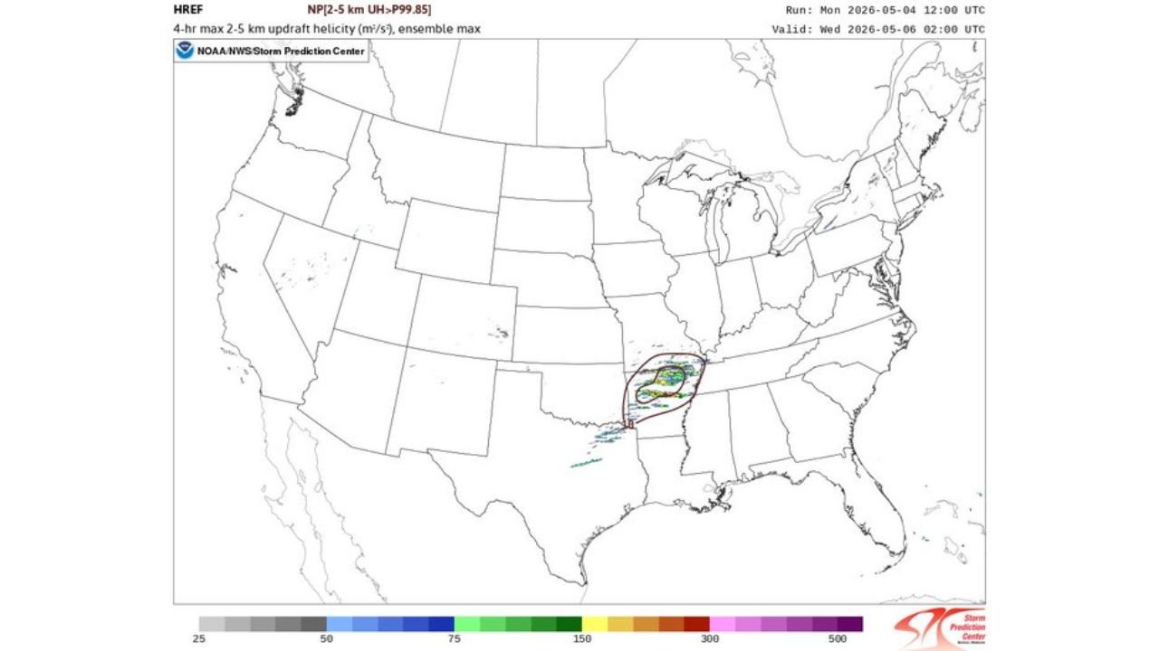
The Updraft Helicity Signal
The HREF ensemble updraft helicity map, showing the probability of 2 to 5 km updraft helicity exceeding the 99.85th percentile, places the highest signal directly over a compact zone covering central Arkansas into northern Mississippi. This product specifically identifies where ensemble members most consistently develop rotating supercell updrafts. A signal concentrated this tightly at this intensity at two days lead time is a serious indicator.
The red-circled zone on this map essentially marks where the models are most confident that supercell thunderstorms with violent rotating updrafts will occur Wednesday evening.
All-Hazards Threat Summary
Every severe weather hazard type is possible Wednesday across Arkansas and Mississippi:
Significant tornadoes are the primary concern given STP of 2.4, SRH of 864, Critical Angle of 75 degrees and the TGR SARS flag. Any discrete supercell that stays isolated through the evening carries a legitimate EF2 or greater tornado potential.
Giant hail is explicitly flagged in the SARS analog output. DCAPE of 852 and the strong updraft profile support hailstones large enough to cause serious vehicle and structural damage.
Damaging straight-line winds become the dominant threat if storms consolidate into a squall line before peak intensity is reached.
What Residents Across Arkansas and Mississippi Must Do Before Wednesday
- Little Rock, Conway, Batesville, Jonesboro in Arkansas and Tupelo, Jackson, Clarksdale in Mississippi are in the highest-risk corridor based on current data
- Shelter locations should be identified today, not Wednesday afternoon
- Battery-powered weather radio and phone alert systems should be active and tested before Wednesday morning
- The late afternoon and evening timing gives residents daylight hours to prepare, but storms can move fast once they initiate
- Anyone in a mobile home or vehicle should identify a sturdy shelter alternative before Wednesday arrives
WaldronNews.com will continue tracking Wednesday’s Arkansas and Mississippi severe weather threat and will provide updated coverage daily as the event approaches.