
Emerging El Nino Set to Make Summer 2026 Hotter Than Normal Across Texas, Louisiana, Mississippi, Georgia and Florida While Great Lakes and Northeast Run Cooler
HOUSTON, Texas — An emerging El Nino pattern is shaping up to be the dominant force behind Summer 2026 temperatures across the United States, with a temperature outlook issued May 4, 2026 calling for an above-average summer across the South and West and a below-average summer across the Great Lakes, Upper Midwest and Northeast. By the end of summer, forecasters expect the pattern to be flirting with strong El Nino territory, a development that would have lasting consequences into next winter as well.
What El Nino Does to a United States Summer
Historical data covering 29 El Nino summers shows a remarkably consistent pattern across the country. The global temperature frequency map makes the track record clear:
- The South and Gulf Coast have run warmer than average in the overwhelming majority of past El Nino summers, with the deepest red shading concentrated across Texas, Louisiana, Mississippi, Alabama, Georgia and Florida
- The northern United States and Canada tend to run cooler than average during El Nino summers, with blue shading dominating from the Great Lakes through New England
- The central Plains show more mixed results, reflected in the equal chances zone on the summer outlook map
The 2026 summer outlook follows this historical template almost exactly.
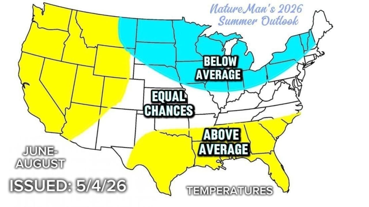
Where Temperatures Land This Summer
The temperature outlook for June through August 2026 divides the country into three clear zones:
Above Average — Yellow:
- Texas, Louisiana, Mississippi, Alabama, Georgia, Florida — the entire Deep South
- Pacific Coast from California through Washington
- Parts of the Mountain West
Below Average — Blue:
- Minnesota, Wisconsin, Michigan, Ohio, Indiana — the Great Lakes corridor
- Iowa, Nebraska, South Dakota, North Dakota
- New York, Pennsylvania, New England and most of the Northeast
Equal Chances — White:
- A transition zone through the central Plains and Rockies including Colorado, Kansas, Missouri and Tennessee
Where El Nino Is Heading by Summer’s End
The ENSO model forecast chart from April 2026 shows the trajectory of the Nino3.4 Sea Surface Temperature anomaly, the primary index used to measure El Nino strength. Every major forecasting model is in agreement that El Nino will strengthen through 2026:
- Current observed value: Slightly below zero, essentially neutral as of early 2026
- By June-August 2026: Most models converge on anomalies of +1.0 to +2.0 degrees Celsius
- By October-December 2026: The dynamical model average climbs toward +1.5 to +2.0 degrees Celsius, with some individual models reaching +3.5 degrees
- The dynamical model average and statistical model average both clearly trend upward through the remainder of 2026
An anomaly of +1.5 degrees Celsius or greater qualifies as a moderate El Nino. Several models push toward strong El Nino territory by late 2026.
What This Means for Winter 2026 Into 2027
El Nino’s influence flips between seasons. While it drives a warmer South and cooler North in summer, the winter pattern typically reverses. A strengthening El Nino heading into Winter 2026-2027 would likely bring:
- A warmer than average winter across the northern United States including the Great Lakes and Northeast
- Equal chances across the southern tier, meaning no clear signal yet for whether the South will run warm or cold next winter
Residents across Texas, Louisiana and the Deep South who face a hot summer should be aware that winter relief may be limited as well, with the pattern potentially keeping warmth locked across the southern states into early 2027.
WaldronNews.com will continue tracking El Nino development and its impact on United States weather through Summer and Winter 2026 and will provide updated seasonal outlooks as the pattern evolves.