
Arkansas Faces Strong Tornadoes, Large Hail and Damaging Winds Wednesday Evening as Mid-60s Dewpoints and 35 to 40 Knots of Low-Level Shear Load the Atmosphere
LITTLE ROCK, Arkansas — The atmosphere across Arkansas is loading up for a dangerous Wednesday evening, May 6, 2026, with conditions favorable for strong tornadoes, large hail and damaging winds as scattered supercells are expected to fire by evening across a state sitting directly in the crosshairs of a powerful low-level wind shear and moisture overlap. Any storm that develops and stays isolated Wednesday evening will carry a legitimate strong tornado threat.
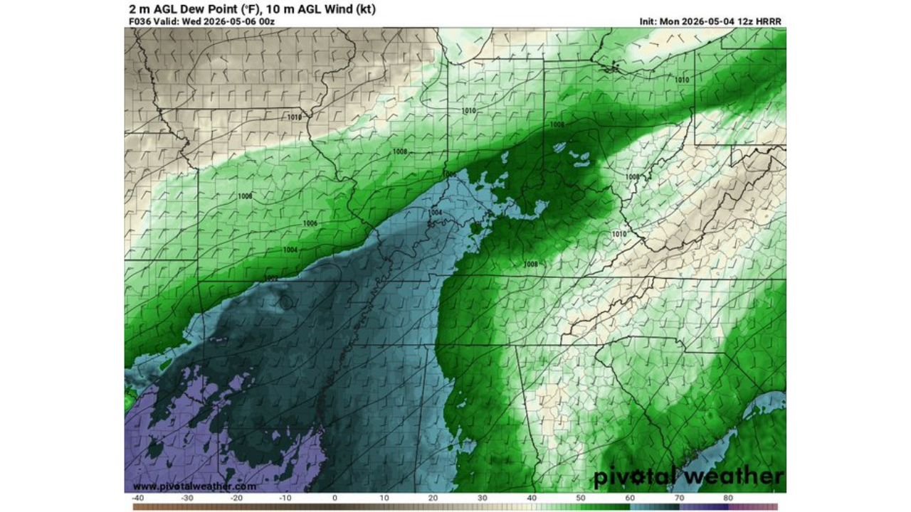
What the Atmosphere Is Doing
Three separate data fields valid Wednesday, May 6 at 00z paint a concerning picture for Arkansas and surrounding areas.
Low-Level Jet — 850 mb Winds The most intense winds at 850 millibars are concentrated in a deep magenta and red core centered directly over Arkansas and Tennessee, with values reaching 50 to 80 knots. This explosively strong low-level jet is the primary engine driving rotational potential for any supercell that develops Wednesday evening. The tighter the wind shear in the lowest levels of the atmosphere, the greater the tornado threat from discrete storms.
Surface Moisture — Mid-60s Dewpoints Dewpoints across Arkansas are sitting in the mid-60s Fahrenheit ahead of the approaching boundary, shown in the green shading on the dewpoint map. The dryline and surface boundary pushing from the southwest are creating a sharp moisture contrast directly over Arkansas, which is exactly where storms will be most likely to initiate Wednesday evening.
Instability — Mixed Layer CAPE The CAPE map shows the highest instability values, reaching 2,000 to 3,000+ J/kg in orange and red shading, positioned across Louisiana and eastern Texas pushing into southern Arkansas. Mixed-Layer CAPE, or Convective Available Potential Energy, measures the fuel available for thunderstorm updrafts. Values of 2,000+ J/kg are sufficient to support violent updrafts in well-organized supercells.
What the Sounding Data Shows for Arkansas
A model sounding valid Wednesday May 6 at 01z positioned at 35.31°N, 93.21°W over central Arkansas reveals the full picture:
- Surface CAPE: 737 J/kg, forecast CAPE rising to 3,315 J/kg as destabilization occurs through the day
- Storm-Relative Helicity: 1,060 m²/s² — an exceptionally high value indicating extreme rotational potential in the lowest levels of the atmosphere
- Effective Bulk Wind Difference: 105 m²/s² — very strong deep-layer shear supporting organized supercell structures
- STP (Significant Tornado Parameter): 4.9 — values above 1 indicate significant tornado potential. At 4.9, this environment is firmly in high-end tornado territory
- Supercell Composite: 9.1 — extremely high, confirming a very favorable environment for long-lived rotating supercells
- Critical Angle: 63 degrees — within the favorable range for tornado-producing supercells
- SARS analog: Supercell and Significant Hail confirmed by the sounding analog matching system
- LCL height: 1.6 km — low enough to support tornado development
The Key Variable: Storm Mode
The difference between a significant tornado outbreak and a wind event Wednesday evening comes down to storm mode:
If storms fire as discrete supercells and remain isolated, the STP of 4.9 and SRH of 1,060 create an environment capable of producing EF2 or stronger tornadoes across Arkansas.
If storms consolidate into a squall line before reaching peak intensity, the tornado threat decreases and the primary hazard shifts toward widespread damaging straight-line winds.
Forecasters are watching whether additional destabilization occurs through Wednesday afternoon. If CAPE values rise toward the 3,000+ J/kg forecast level, a more robust and dangerous threat takes shape across the entire state.
Cities and Areas Facing the Highest Risk
Based on the moisture, shear and instability overlap currently modeled for Wednesday evening, the highest risk corridor runs through:
- Little Rock and surrounding central Arkansas communities
- Fort Smith and the Arkansas River Valley
- Jonesboro and northeastern Arkansas as storms mature and move east
- Texarkana area along the Texas-Arkansas border where initiation is most likely
What Arkansas Residents Must Do Before Wednesday Evening
- Have a weather alert method active and tested before Wednesday afternoon. Storms initiating at evening means the window to prepare is during daylight hours Wednesday
- Identify your nearest sturdy shelter now. Interior rooms on the lowest floor away from windows are the safest locations during a tornado warning
- Do not rely solely on outdoor sirens. With SRH values of 1,060 and STP near 5, any warned storm Wednesday evening should be treated as capable of producing a significant tornado immediately
- Monitor updated forecasts through Tuesday night and Wednesday morning as storm mode confidence will increase significantly with shorter-range data
WaldronNews.com will continue tracking Wednesday’s Arkansas severe weather threat and will provide daily updates as the event approaches and storm mode confidence increases.