
Central and North Florida Stay Bone Dry as Only the Florida Keys See Rain While the Rest of the State Bakes Without Relief
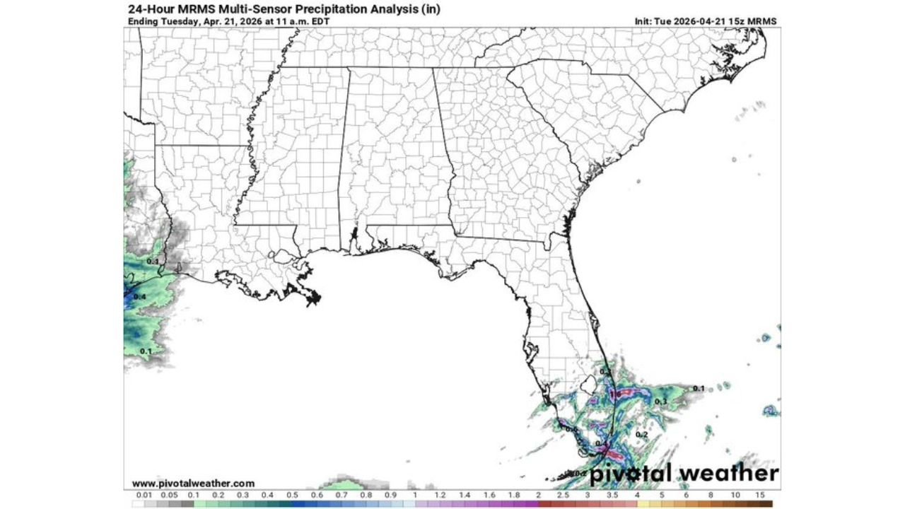
ORLANDO, Florida — The drought divide across Florida could not be more stark. In the past 24 hours ending Tuesday, April 21, virtually every drop of rainfall across the entire state was concentrated near the Florida Keys and offshore waters — while Central Florida, North Florida, and the entire Gulf Coast received essentially zero measurable precipitation. Not a tenth of an inch. Not even a trace across most of the state.
This is not a one-day anomaly. It is the continuation of a pattern that has been squeezing Florida dry since October 2025.
Florida Communities That Received Zero Rain in the Past 24 Hours
The rainfall map shows a nearly blank slate across the entire state:
- Orlando, Florida: Zero rainfall — Central Florida completely dry
- Tampa, Florida: No measurable precipitation in the past 24 hours
- Jacksonville, Florida: North Florida remaining bone dry
- Gainesville, Florida: Zero rain as the drought continues uninterrupted
- Tallahassee, Florida: Panhandle area receiving nothing
- Fort Myers and Naples: Southwest Florida coast — completely dry
- Georgia and Alabama: The entire Southeast above Florida also showing near-zero rainfall
What the Map Is Showing
The 24-hour precipitation analysis reveals a pattern that keeps repeating:
- Florida Keys and offshore: The only area in the entire state seeing any rainfall — small pockets of 0.1 to 0.2 inches near the Keys and coastal waters
- Entire Florida Peninsula: Completely white on the rainfall map — zero to trace amounts statewide
- Southeast coast: Minimal moisture confined to the far southern tip, unable to push inland
- Rest of the Southeast: Alabama, Georgia, Mississippi — equally dry in the past 24 hours
Why Moisture Keeps Missing Central and North Florida
Orlando, Florida and the broader peninsula have been locked out of meaningful rainfall by a persistent atmospheric pattern that keeps moisture bottled up at the very southern tip of the state — or pushes it entirely offshore.
The Keys and near-shore waters receive occasional shower activity because sea surface temperatures around South Florida remain warm enough to trigger isolated convection over the water. But that moisture does not translate inland. The atmospheric setup consistently prevents shower activity from pushing northward into Central Florida, the I-4 corridor, Tampa Bay, or the North Florida communities that desperately need it.
What makes today’s map particularly sobering is the geographic scope of the dryness. Look at the entire Southeast on this map — Alabama, Georgia, Mississippi, the Carolinas — all showing the same blank white reading. This is a regional atmospheric pattern failure, not just a local Florida problem. The moisture that should be spreading across the Southeast is being blocked at every turn.
For Tampa and Orlando — two of Florida’s largest metro areas — another completely dry 24-hour period means another day of the drought deepening. Every dry day adds to a deficit that now stands at 15 to 20 inches below normal since October. Every dry day pushes the recovery timeline further into the future.
The wildfire threat that this ongoing dryness creates remains at critical levels. With mid-90s temperatures building and no rainfall reaching the interior of the state, the vegetation moisture content across Central and North Florida continues dropping toward dangerous levels.
Multi-Day Pattern
The next 24 to 48 hours show no change in this pattern. Moisture remains confined to the far southern tip and offshore waters. No meaningful rainfall is forecast for Central or North Florida through the rest of this week. The next realistic opportunity for any interior Florida rainfall remains at least several days away — and even then, the signal is not strong.
What to Watch Next
- Whether any sea breeze convection manages to push inland toward Orlando or Tampa Bay in the coming days
- Daily high temperatures across North Florida as the dry pattern and mid-90s heat build simultaneously
- Active wildfire incidents across Central and North Florida as fuel moisture continues dropping
- Whether the Keys moisture eventually expands northward or remains confined offshore
- Next week’s pattern — any signals of moisture returning to the Florida Peninsula
Residents across Central Florida, North Florida, and the Gulf Coast should continue all water conservation measures and remain alert to wildfire danger. The pattern keeping Florida dry is stubborn and showing no signs of breaking in the near term.
WaldronNews.com will continue tracking Florida’s ongoing drought and provide daily updates as rainfall patterns and wildfire danger evolve.