
Arkansas, Mississippi, Alabama and Tennessee Face Significant Tornado Threat Monday April 27 as Gulf Moisture and Jet Stream Collide Across the Mid-South
MEMPHIS, Tennessee — Monday, April 27 has the potential to deliver a significant severe weather event across the Mid-South, Deep South, and Mississippi Valley — and tornado activity is anticipated. The atmospheric setup is drawing serious attention from forecasters, with ample Gulf moisture surging north combining with a racing subtropical jet stream to create a dangerous storm environment across Arkansas, Mississippi, Alabama, Tennessee, Missouri, Illinois, Indiana, and Kentucky.
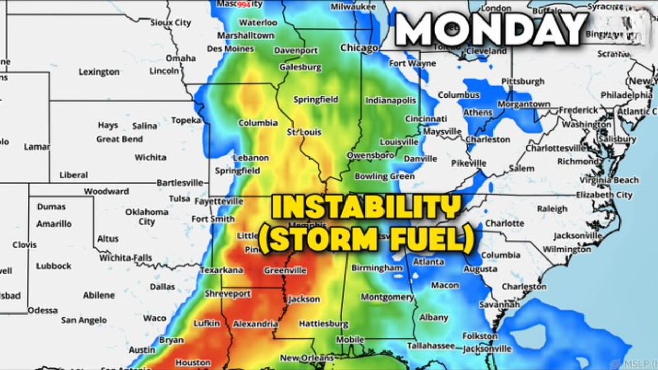
The instability map for Monday tells the story immediately — a massive plume of deep red and orange storm fuel is loaded across the entire Mid-South corridor, from Little Rock and Memphis through Birmingham, Nashville, and Louisville. When that much instability meets strong upper-level wind energy, tornadoes become not just possible but likely.
States and Cities That Need a Severe Weather Plan Before Monday
The threat zone covers a densely populated Multi-state corridor:
- Arkansas: Little Rock and the River Valley — sitting in the core of Monday’s instability plume with tornado activity anticipated
- Mississippi: Jackson, Tupelo, and Greenville — deep inside the red instability zone with the highest storm fuel values on the map
- Alabama: Birmingham, Huntsville, and Tuscaloosa — already inside the defined severe weather risk zone for Monday
- Tennessee: Memphis and Nashville both inside the danger corridor — Nashville was already flagged as one of the farthest-east severe threats of the season
- Missouri: St. Louis and Springfield on the northern edge of the instability plume
- Illinois: Springfield and southern Illinois included in the threat zone
- Indiana: Indianapolis corridor on the northeastern fringe of the severe weather risk area
- Kentucky: Louisville and Bowling Green inside the outlined threat zone
Primary Threats Monday
The atmospheric ingredients for dangerous storms are aligning:
- Tornadoes — machine learning storm models are bullish on tornado activity Monday; the combination of Gulf moisture, surface low drawing wind shear, and subtropical jet stream energy aloft creates a classic tornado-producing setup
- Massive instability — the storm fuel map shows deep red values across the entire Mid-South, from Arkansas through Alabama — this is the energy that powers violent thunderstorms
- Subtropical jet stream energy — racing overhead and adding significant wind energy to the upper atmosphere, providing the rotation potential that turns ordinary thunderstorms into supercells
- Damaging winds — as storm clusters organize Monday afternoon and evening, widespread straight-line wind damage is expected alongside tornado threats
- Large hail — supercells developing in this environment will produce significant hail before and during tornado phases
Why Monday’s Setup Is Getting So Much Attention
Memphis, Tennessee sits at the geographic heart of Monday’s most dangerous zone — and the reason forecasters are paying such close attention comes down to the specific combination of ingredients in play.
A surface low tracking somewhere over the Midwest will pull Gulf warmth and moisture northward all day Monday. That moisture surge feeds directly into the instability values shown on the map — the deep red covering Arkansas, Mississippi, and Alabama represents thunderstorm fuel at levels that can support violent, long-track tornadoes. The exact position of the surface low matters less than what it is doing: pumping unstable air northward and creating strong low-level wind shear across the entire Mid-South.
Simultaneously, the subtropical jet stream is racing overhead — adding a powerful upper-level wind component that provides the rotation mechanism for supercells. When surface wind shear from the low-level jet combines with upper-level wind energy from the subtropical jet, the result is a deep layer of rotating wind that supercells can tap into from ground to cloud top.
Machine learning storm models — which have demonstrated strong accuracy in pattern-matching tornado outbreak setups — are showing bullish signals for tornado activity across this corridor on Monday. That does not guarantee a major outbreak, but it means the atmospheric profile resembles past events that produced significant tornadoes.
Alabama is particularly vulnerable. The state’s 89% drought coverage means the soil is extremely dry — dry soil heats faster, which accelerates afternoon instability development. A faster instability ramp-up means storms can fire earlier and with more energy than a moist-soil environment would produce.
There remains significant uncertainty in the exact timing, storm mode, and specific locations of greatest impact. But the overarching pattern is concerning enough that forecasters have already drawn a defined severe weather risk zone — and that designation at Day 6 range is not issued casually.
Multi-Day Pattern
Monday follows a weekend that is itself already active — Saturday and Sunday carry tornado outbreak potential across Oklahoma, Kansas, and North Texas from the dryline setup. That energy then sweeps eastward, and by Monday it is targeting the Mid-South and Deep South. This represents a continuous severe weather train rolling from the Southern Plains through Tornado Alley and into the Mississippi Valley over a three-day period.
After Monday, a brief quieter stretch is possible before the next pattern cycle begins in early May.
What to Watch Next
- Forecast updates Saturday and Sunday as Monday’s setup comes into sharper focus
- Surface low track determination — where it sets up will define the exact corridor of greatest Monday tornado risk
- Tornado watch issuances Monday afternoon for Arkansas, Mississippi, and Alabama
- Whether the machine learning model signal for tornado activity strengthens or weakens as Monday approaches
- Storm initiation timing Monday — afternoon vs. evening storms will significantly affect which communities face the greatest danger
If you live in Arkansas, Mississippi, Alabama, Tennessee, Missouri, Illinois, Indiana, or Kentucky — have your severe weather plan ready before the weekend arrives. Know where you will shelter, how you will receive warnings, and what you will do if a tornado warning is issued for your area. Monday has the potential to be a significant severe weather day across the entire Mid-South.
WaldronNews.com will continue tracking Monday’s developing tornado threat and provide frequent updates through the weekend as the forecast sharpens.