
Florida and the Deep South Face One of the Hottest Driest Summers in Years as Below Normal Rain Forecast Through September With Mid 90s Arriving by May
TAMPA, Florida — The forecast could not be more clear — or more alarming. Florida and the Deep South are staring down what could be one of the hottest and driest summers in recent memory, with the official seasonal precipitation outlook showing below-average rainfall through July, August, and September across the region. And the heat is not waiting for summer — mid-90s are possible by May across parts of Florida, with no meaningful rainfall relief in sight for the next 30 days or longer.
For outdoor workers, farmers, and anyone without reliable air conditioning, this summer outlook is a serious warning.
States Facing Below Normal Summer Rainfall
The seasonal outlook paints a dry picture across a wide swath of the country:
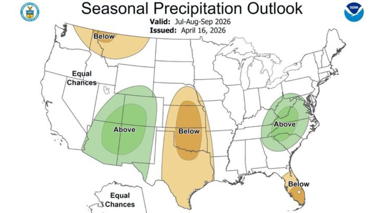
- Florida: Below-normal precipitation forecast for the entire summer season through September — the drought that has already consumed 100% of the Southeast will deepen further
- Oklahoma: Below-normal summer rainfall outlook covering the state
- Kansas: Included in the below-normal precipitation zone through the summer months
- Nebraska: Summer rainfall running below average through July-September
- Mississippi: On the edge of the below-normal zone as the dry pattern persists
- Pacific Northwest: Washington and Oregon facing below-normal summer precipitation
What the Summer Outlook Means in Plain Terms
The seasonal forecast carries several alarming implications:
- No rain relief for 30+ days across Florida — the drought that has been building since October 2025 continues deepening with no end in sight
- Mid-90s possible by May across North Florida — soil so dry it heats faster than normal, pushing temperatures above what seasonal averages would suggest
- Below-normal rainfall July through September — the heart of Florida’s traditional rainy season is forecast to underperform, meaning the drought does not recover even when summer storms arrive
- One of the hottest driest summers in quite some time — the combination of existing drought, below-normal summer rainfall forecast, and early extreme heat creates conditions not seen in this region in years
- Dangerous for outdoor laborers — hitting mid-90s by May while humidity is already climbing creates heat index values well above 100°F for anyone working outside
Why This Summer Outlook Is So Serious for Florida
Tampa, Florida and communities across the Sunshine State are already in extreme drought — three-quarters of the state is classified at the second-worst drought level possible. The seasonal precipitation outlook now confirms what many feared: there is no cavalry coming.
Florida’s summer rainy season — typically running June through September — is the state’s primary mechanism for drought recovery. Afternoon thunderstorms firing daily across the peninsula normally deliver 50 to 60 inches of annual rainfall to central Florida, with much of it concentrated in these summer months. When the seasonal outlook shows below-normal precipitation through the entire summer, it means even Florida’s best natural drought-recovery window is expected to underperform.
The mid-90s by May projection is particularly concerning for several reasons. First, it confirms that the heat is arriving ahead of schedule — before the humidity of true summer sets in and before outdoor workers, utilities, and agriculture have fully prepared for extreme heat conditions. Second, temperatures in the mid-90s combined with Florida’s current drought-stressed vegetation means wildfire danger remains critical well into what should be the rainy season transition.
For outdoor laborers — construction workers, landscapers, agricultural workers, utility crews — this is a direct safety warning. Heat index values regularly exceeding 105°F during outdoor working hours become life-threatening, especially in May and June before the body has had time to acclimatize to summer heat. Heat exhaustion and heat stroke risk spikes dramatically in conditions like these.
The 30-day rain-free outlook means the soil moisture deficit that already stands at 15 to 20 inches below normal since October will continue growing. Every day without rain makes drought recovery more difficult. Every day of mid-90s heat accelerates evaporation from already-depleted soil and water bodies.
Multi-Day Pattern
The immediate pattern offers no relief. The next two weeks show no meaningful rainfall for Florida. Beyond two weeks, the 30-day outlook shows no real signals of pattern change. The summer seasonal forecast through September confirms below-normal precipitation as the expected outcome even during Florida’s traditional rainy season months. The only realistic drought-recovery scenario involves either an early tropical system delivering significant rainfall or an unexpected pattern shift — neither of which is currently signaled in any forecast.
What to Watch Next
- Daily high temperature records across North and Central Florida as mid-90s heat builds in May
- Red flag fire weather warnings as the combination of 90s heat, zero rainfall, and dry vegetation continues
- Heat advisories for outdoor workers across Florida’s agricultural communities
- Whether any early tropical activity in the Gulf of Mexico or western Caribbean delivers rainfall to drought-stricken Florida before peak summer
- Summer drought monitor updates tracking whether Florida’s extreme drought classification worsens to exceptional — the most severe level possible
Residents across Florida, Oklahoma, Kansas, and the Deep South should take this summer outlook seriously and begin planning now — for water conservation, heat safety, wildfire preparedness, and agricultural drought management. This summer has the potential to be genuinely historic in its heat and dryness.
WaldronNews.com will continue tracking Florida’s drought emergency and the summer heat outlook and provide updates as conditions develop.