
Oklahoma, Kansas and North Texas Face Tornado Outbreak This Weekend as Classic Dryline Event Peaks Sunday Across Tornado Alley
OKLAHOMA CITY, Oklahoma — A tornado outbreak is possible this weekend across the Southern Plains — and the atmosphere is setting up in a way that forecasters describe as a classic dryline tornado event. Oklahoma, Kansas, and North Texas are in the direct path, with the threat building Saturday afternoon and peaking Sunday as peak severe weather season arrives at the heart of Tornado Alley.
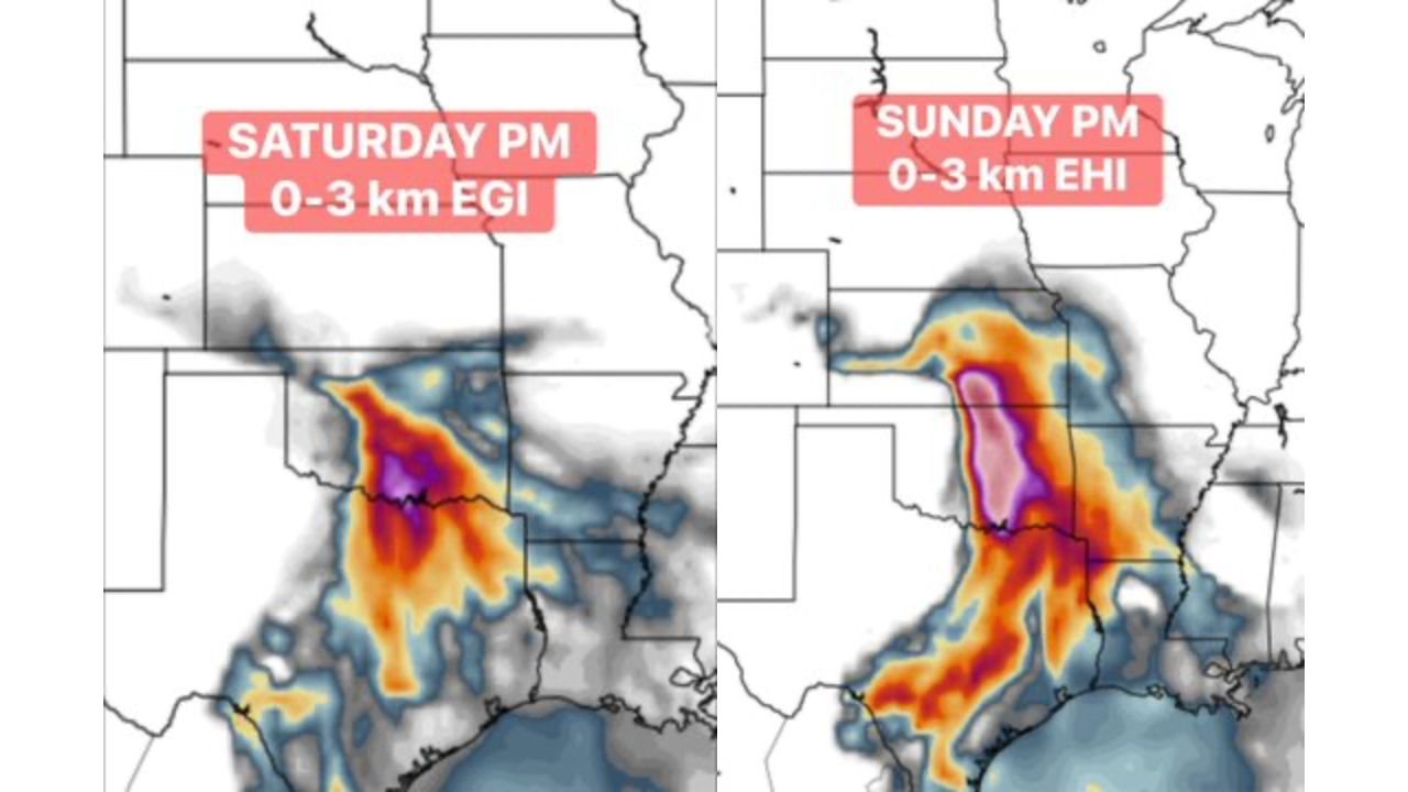
The energy maps tell a frightening story. Saturday PM already shows an intense purple core of rotating storm energy centered over Oklahoma and Kansas. By Sunday PM, that energy expands dramatically — a massive swath of deep red and purple EHI values stretching from North Texas all the way through Oklahoma, Kansas, and into Missouri, signaling the atmosphere is primed for violent, long-track tornadoes.
States and Cities in the Weekend Tornado Outbreak Zone
The dryline tornado threat covers the core of Tornado Alley:
- Oklahoma: Oklahoma City and Tulsa sitting directly inside the highest energy zone both Saturday and Sunday — the purple core on Sunday’s map is centered over central Oklahoma
- Kansas: Wichita and surrounding south-central Kansas in the bull’s-eye for Sunday’s peak tornado threat
- North Texas: Dallas-Fort Worth corridor and the Texas Panhandle on the southern end of the dryline event Saturday
- Missouri: Springfield and southwest Missouri on the northeastern fringe of Sunday’s expanding threat zone
- Arkansas: Western Arkansas included as the energy field expands eastward Sunday afternoon
Primary Threats Saturday and Sunday
The weekend setup carries every severe weather danger:
- Tornadoes — the primary and most dangerous threat both days; Sunday’s EHI map shows values consistent with violent, long-track tornado potential across central Oklahoma and south-central Kansas
- Classic dryline supercells — the setup features the textbook Tornado Alley ingredients: Gulf moisture surging north, dry air from the west, and jet stream energy overhead creating the perfect supercell environment
- Large hail — supercells firing along the dryline will produce significant hail before tornado potential develops; baseball to softball-size hail possible
- Damaging winds — as storm clusters organize later in the evening, widespread straight-line wind damage becomes an additional threat
- Sunday peak — Sunday’s EHI field is dramatically larger and more intense than Saturday’s, indicating Sunday carries the highest outbreak potential of the two-day event
Why Oklahoma City and Wichita Are Ground Zero
Oklahoma City, Oklahoma has been through more tornado outbreaks than almost any city in America — but what is setting up this weekend has forecasters paying close attention. The dryline is the key ingredient. This boundary between hot, dry air from the west and warm, humid Gulf air from the south is where the most dangerous supercells in American history have formed. When the dryline sharpens on a day with strong jet stream energy overhead and deep Gulf moisture in place, the result is often violent tornadoes.
The Saturday PM energy map already shows a concentrated purple core — the highest values on the scale — centered directly over Oklahoma and southern Kansas. That signal on Saturday is concerning on its own. The Sunday PM map is what truly stands out: the entire energy field expands northward and eastward, with the purple and deep red zone now covering a massive corridor from North Texas through Oklahoma City, Wichita, and into southwest Missouri. That geographic expansion means Sunday’s tornado threat is not just more intense — it covers a much larger area.
Wichita, Kansas sits in one of the most tornado-vulnerable positions of any major American city, sitting directly on the dryline corridor where storms most frequently fire. A weekend setup like this one, with the energy values shown on Sunday’s map, represents exactly the kind of pattern that has produced Wichita’s worst historical tornado events.
For North Texas and the Dallas-Fort Worth area, Saturday PM is the more relevant window. The dryline typically fires from south to north during the afternoon heating hours — meaning North Texas sees storm initiation first on Saturday before the energy maxes out over Oklahoma and Kansas by evening.
The phrase “peak severe weather season is about to arrive” is not hyperbole for this region. Late April and May represent the climatological peak of tornado activity across Oklahoma and Kansas — and this weekend’s setup appears to be arriving right on schedule with all the classic ingredients in place.
Multi-Day Pattern
Saturday afternoon — dryline fires across North Texas and southern Oklahoma; first supercells develop with tornado and large hail threats. Saturday evening — storms mature and track northeast through Oklahoma and into Kansas. Sunday — the atmosphere reloads with even greater instability and the dryline resharpens; Sunday afternoon through evening is the peak outbreak window across Oklahoma and Kansas. Monday — the system pushes into the Tennessee Valley and Mid-South, where a separate major severe weather threat is already defined for Alabama, Tennessee, and Mississippi.
What to Watch Next
- Tornado watch issuances Saturday afternoon for North Texas and southern Oklahoma as the dryline fires
- Whether Saturday’s storms produce significant tornadoes before Sunday’s even larger setup arrives
- Sunday morning forecast updates — how sharp the dryline becomes will determine how organized and violent Sunday’s supercells are
- EHI and energy field updates Saturday night as forecasters refine Sunday’s outbreak potential
- Storm reports Saturday evening from the Oklahoma City and Tulsa corridors
Residents across Oklahoma, Kansas, and North Texas need to treat this weekend as a serious, potentially historic tornado threat. Have your shelter plan ready before Saturday arrives — do not wait for the tornado watch to be posted. When the atmosphere is loaded like this, storms can go from initiation to violent tornado in under 30 minutes.
WaldronNews.com will continue tracking this weekend’s tornado outbreak potential and provide updates as Saturday and Sunday’s setups come into sharper focus.