
Iowa, Illinois, Missouri and Tennessee Brace for 5 Straight Days of Tornadoes Hail and Damaging Winds From Thursday Through Monday
KANSAS CITY, Missouri — The severe weather calendar is filling up fast — and residents across the Plains, Midwest, and Mid-South are staring down a five-day stretch of back-to-back severe weather threats running from Thursday April 23 all the way through Monday April 27. Every single day in this window carries a threat of tornadoes, damaging winds, and large hail across a shifting corridor that moves progressively eastward through the week.
This is not one storm. This is five consecutive days of dangerous weather targeting millions of people across Iowa, Illinois, Missouri, Kansas, Oklahoma, Tennessee, Mississippi, and Arkansas.
The Five-Day Severe Weather Corridor
Each day brings a different primary target zone:
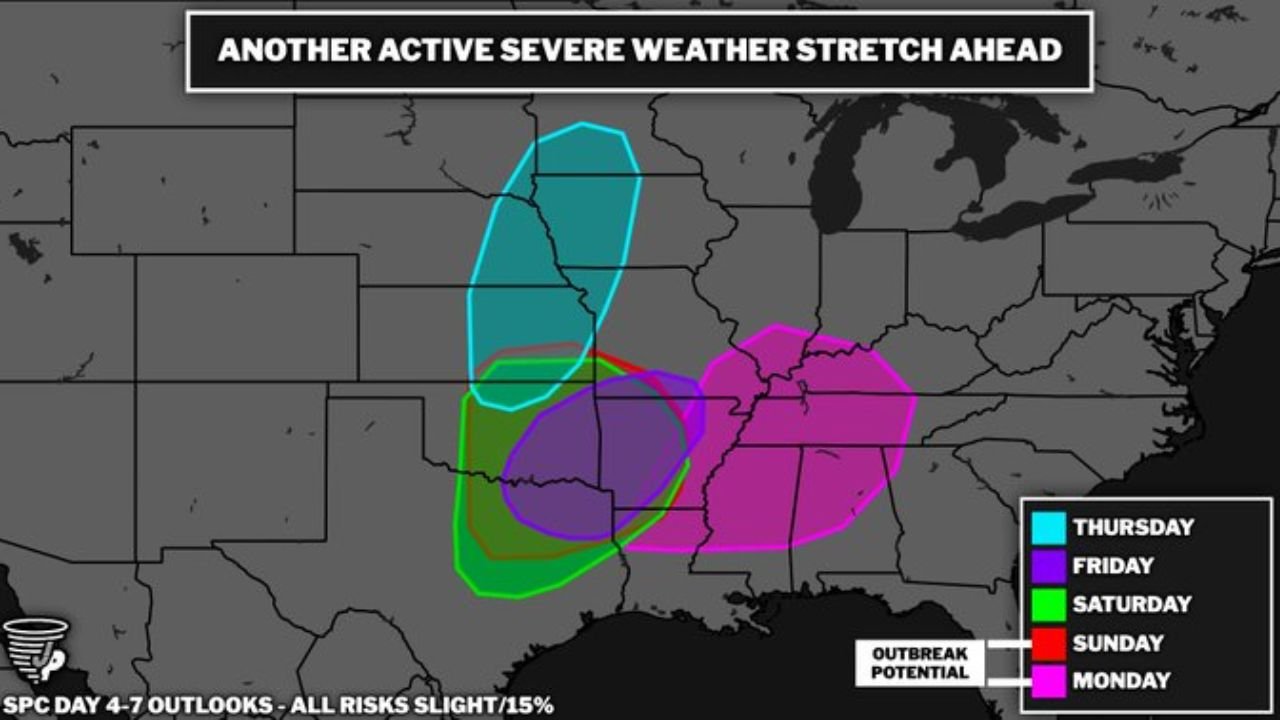
- Thursday: Kansas, Nebraska, Iowa — supercell and squall line threat with tornadoes possible from Oklahoma City through Wichita and Omaha; 60+ mph winds targeting Minnesota and Iowa
- Friday: Missouri, Illinois, Iowa — the severe threat corridor shifts east as the Thursday system exits; damaging winds and hail primary threats
- Saturday: Missouri, Arkansas, Tennessee, Mississippi — the setup expands southeastward with outbreak potential flagged; tornado, hail, and wind threats for Memphis, Little Rock, and Nashville
- Sunday: Tennessee, Kentucky, Mississippi, Alabama — identified as one of the two “big days” with a very unstable environment and strong upper-level support; highest tornado potential of the weekend
- Monday: Tennessee, Alabama, Mississippi, Arkansas — the second “big day”, with the severe threat pushing into the heart of the Mid-South targeting Nashville, Birmingham, Huntsville, and Jackson
Primary Threats Across the Five-Day Window
Every day in this stretch carries the full suite of severe weather dangers:
- Tornadoes — all five days carry tornado potential; Sunday and Monday flagged as the days with the most unstable environment and best upper-level support for significant tornado development
- Large hail — Thursday’s supercell potential over Kansas and Oklahoma brings tennis ball-size hail risk; subsequent days maintain hail threats as storm energy remains potent
- Damaging winds — squall lines and bow echoes capable of 60+ mph straight-line wind gusts expected on multiple days across the corridor
- Outbreak potential Saturday through Monday — the Saturday through Monday period carries the most concerning signals for a widespread, multi-state severe weather outbreak
Why Five Straight Days Is So Dangerous
Kansas City, Missouri sits near the western edge of this week’s severe weather corridor — and the city’s location illustrates exactly why a five-day stretch like this is so uniquely dangerous. When severe weather strikes repeatedly across the same general region over multiple days, several compounding problems develop that a single-day outbreak does not create.
Emergency management resources get stretched thin. First responders who worked through Thursday’s storms are still processing damage reports when Friday’s threat arrives. Residents who sheltered safely Thursday may become complacent by Sunday and Monday — exactly when the atmosphere is signaling its most dangerous days.
Power outages from earlier storm days leave communities vulnerable when the next round hits. Trees already weakened by wind damage from Thursday fall more easily when Friday’s storms arrive. And the psychological fatigue of repeated severe weather alerts can cause people to tune out warnings at exactly the wrong moment.
Sunday and Monday stand out as the days forecasters are watching most closely. The description of a “very unstable environment with good upper-level support” for both days — combined with the outbreak potential flag on the Day 4-7 outlook — indicates the atmosphere is loading up for something significant across Tennessee, Alabama, Mississippi, and Arkansas to close out the week.
The eastward progression of the threat zone is also notable. Thursday’s primary action is over Kansas and Iowa. By Monday, the bull’s-eye has shifted to Tennessee, Alabama, and Mississippi — meaning communities in the Mid-South that may feel distant from Thursday’s Plains action are actually in the most dangerous part of the pattern by the end of the week.
Multi-Day Pattern
Thursday — Plains and Iowa severe weather day. Friday — threat shifts into Missouri and Illinois. Saturday — severe weather pushes into Arkansas, Tennessee, and Mississippi with outbreak potential. Sunday — big day for the Tennessee Valley and Mid-South with highly unstable atmosphere. Monday — second big day targeting Alabama, Tennessee, Arkansas, and Mississippi before the pattern finally begins to relax. After Monday, a brief quieter period is possible before the next active cycle begins in mid-May.
What to Watch Next
- Thursday’s storm reports from Kansas and Iowa — how well the atmosphere performs sets the tone for the rest of the week
- Saturday’s severe weather upgrade potential as the threat reaches Missouri, Arkansas, and Tennessee
- Sunday and Monday tornado watch issuances for Tennessee, Alabama, and Mississippi
- Whether any single day in this stretch produces a major outbreak comparable to April 17
- Power outage accumulation across the corridor as repeated storm systems move through
Residents across Kansas, Iowa, Missouri, Illinois, Arkansas, Tennessee, Mississippi, and Alabama should treat this entire five-day window as a serious, sustained severe weather threat. Do not let a quiet day in the middle of the stretch lower your guard — the most dangerous days may be Sunday and Monday.
WaldronNews.com will continue tracking all five days of this severe weather stretch and provide updates as each system approaches and individual threats become clearer.