
Georgia, Alabama and Tennessee Finally See Relief as 2 to 3 Inches of Rain Expected by May 1 Ending Weeks of Hot and Dry Pattern
ATLANTA, Georgia — After weeks locked in a hot and dry pattern that has baked Georgia, Alabama, Tennessee, and the broader Southeast, the first real signs of pattern change are finally showing up in the forecast — and the numbers are meaningful. Ensemble data valid through Wednesday April 29 is showing 2 to 3 inches of total rainfall across the region over the next 15 days, with the bulk of that moisture arriving around the first days of May.
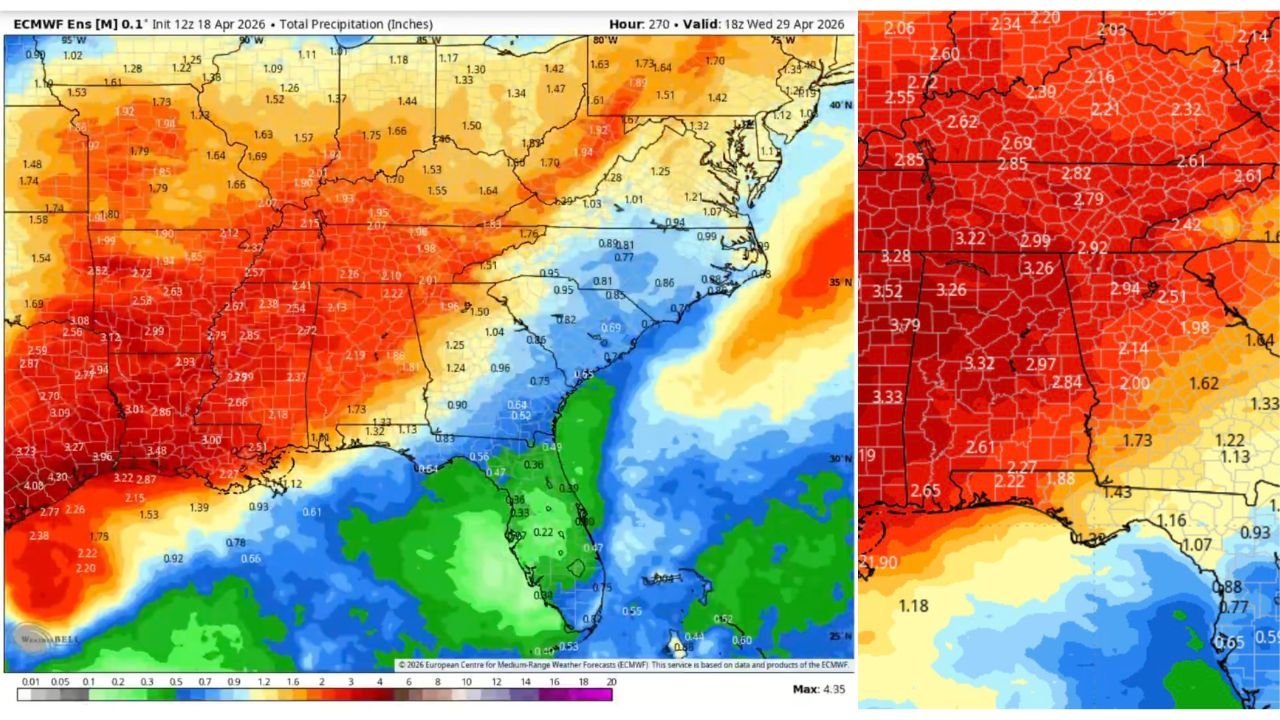
This is not a minor shower event. The precipitation maps covering the Southeast are painted deep red and orange — the color range representing 2.5 to 3.5 inches of accumulated rainfall across a broad swath from Mississippi and Alabama through Georgia, Tennessee, and into the Carolinas. For a region that has been desperately dry, this is the rain that farmers, fire weather forecasters, and water managers have been waiting on.
States and Areas That See the Most Relief
- Alabama: Western and central Alabama showing the heaviest totals — 3.26 to 3.79 inches across much of the state over the 15-day period — the single biggest beneficiary of the pattern change
- Mississippi: Eastern Mississippi corridor picking up 3.22 to 3.52 inches — significant relief for a state that has been deep in drought conditions
- Georgia: Northern and central Georgia seeing 2.61 to 2.99 inches — meaningful improvement for Atlanta and surrounding communities
- Tennessee: Western and central Tennessee picking up 2.69 to 2.85 inches — Nashville, Memphis, and the Chattanooga corridor all in line for beneficial rainfall
- Arkansas: Southern Arkansas showing 2.65 to 3.33 inches on the western edge of the precipitation footprint
- North Carolina: Western North Carolina and the Charlotte corridor seeing 2.21 to 2.61 inches of accumulated rainfall
- South Carolina: Upstate South Carolina in line for 2.32 to 2.51 inches over the period
- Louisiana: Northern Louisiana picking up 2.15 to 2.27 inches on the southwestern edge of the rain shield
Why This Rain Is So Important Right Now
The Southeast has been running a significant moisture deficit through March and into April. The hot and dry pattern that has dominated the region kept temperatures well above normal while rainfall stayed well below — a combination that has stressed agricultural operations, elevated wildfire risk, and drawn down soil moisture reserves across the entire region.
Alabama and Mississippi in particular have been running some of the largest precipitation deficits in the region — which is exactly why those states show the deepest red colors on both the observed deficit map and the upcoming precipitation forecast. The 3.5 to 3.79 inch totals projected for western Alabama and eastern Mississippi over the next 15 days would go a long way toward erasing that deficit.
Georgia farmers heading into the critical spring planting season have been watching dry soils with growing concern. 2.61 to 2.99 inches of rainfall across northern and central Georgia over the next two weeks — if it verifies — arrives at exactly the right time to support field preparation and early crop establishment.
When the Rain Arrives and How It Sets Up
The pattern does not flip overnight. The blocking pattern that has kept the Southeast hot and dry needs a few more days to fully break down before the moisture pipeline from the Gulf of Mexico can reestablish itself northward into the region.
The first meaningful rain chances begin developing around mid to late next week as the pattern starts loosening. The heaviest and most widespread rainfall totals are expected to concentrate around the first days of May — approximately April 28 through May 2 — when the full moisture return and active storm pattern come together across the Southeast.
The ensemble data valid at Wednesday April 29 confirms the deep red precipitation signal is centered squarely over Alabama, Mississippi, Tennessee, and Georgia by that point — meaning the most significant rainfall of the entire 15-day period is still about 10 days away from materializing.
What This Means Going Into Early May
The rainfall pattern change arriving around May 1 sets up the Southeast for a dramatically different early May than the region experienced in April. Instead of the baking heat and dry conditions that characterized the past several weeks, early May is shaping up to be a wetter and more active weather period across Georgia, Alabama, Tennessee, and surrounding states.
That transition brings both benefits and concerns. The obvious benefit is drought relief — soil moisture recovery, reduced fire danger, and improved conditions for agriculture across the region. The concern is that the same pattern change bringing beneficial rain also brings increased severe weather potential as Gulf moisture surges northward and interacts with storm systems dropping out of the Plains.
The Southeast severe weather season historically peaks in April and again in late fall — but early May pattern changes that bring deep Gulf moisture back into the region can produce their own significant severe weather setups, particularly across Alabama, Mississippi, and Tennessee.
What to Watch Over the Next 10 Days
- Pattern change timing — watch for the first rain chances developing across Alabama and Mississippi around April 24 to 26 as the blocking pattern begins relaxing
- Drought monitor updates — the next several Drought Monitor releases will show whether conditions are improving ahead of the main rain event
- Fire weather alerts — the window between now and the rain arrival around May 1 remains a period of elevated fire risk across Georgia, Tennessee, and Alabama
- Severe weather potential — as Gulf moisture returns around April 28 to May 2, watch for severe weather setups developing across the region alongside the beneficial rainfall
- Flooding concern — after weeks of dry and hard-packed soil, the first heavy rains can run off quickly rather than soaking in — flash flooding is possible with heavier rain totals across areas with the deepest soil moisture deficits
Residents across Georgia, Alabama, Tennessee, and the broader Southeast have been waiting weeks for this pattern change. It is finally coming — but it will take until the end of the month to fully arrive.
WaldronNews.com will continue tracking the developing pattern change across the Southeast and provide updates as rainfall chances increase heading into late April and early May.