
Kansas and Oklahoma Brace for Next Severe Weather Outbreak Thursday April 23 as Active Jet Stream and Gulf Moisture Target Wichita Oklahoma City and Woodward
WICHITA, Kansas — The historic severe weather sequence that just tore through Iowa, Illinois, Indiana, and Wisconsin this weekend is winding down — but the atmosphere is already reloading. All eyes across the Southern Plains are now turning to the middle and late portion of this coming week, where a fresh and potentially significant severe weather stretch is taking shape from Wednesday through at least the weekend — with Thursday April 23 already carrying a 15% tornado probability across Kansas and Oklahoma.
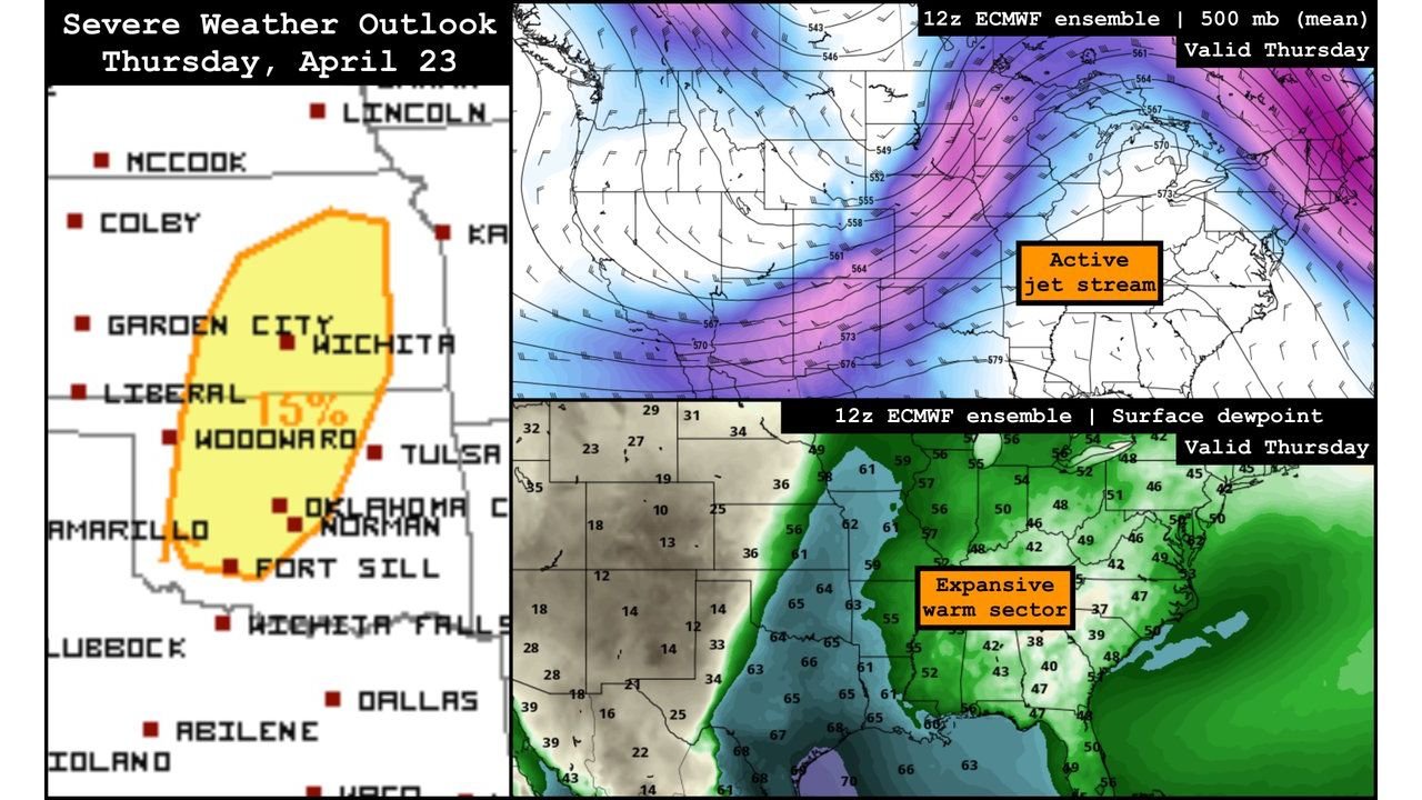
A powerful active jet stream is forecast to return and collide with an expansive warm sector surging northward from the Gulf Coast into the Midwest by mid-week. The combination of those two ingredients — the same basic recipe that produced this weekend’s outbreak — is setting up again across the Southern Plains with Wichita, Oklahoma City, Woodward, Garden City, and Liberal sitting inside the Thursday severe weather probability area.
States and Cities Already in the Thursday Outlook
- Kansas: Wichita, Garden City, Liberal, Colby, McCook — inside the 15% tornado probability zone already outlined for Thursday April 23
- Oklahoma: Oklahoma City, Norman, Tulsa, Woodward, Fort Sill — in the southern portion of the Thursday severe weather outlook area
- Texas: Amarillo, Wichita Falls, Abilene, Dallas on the southern and eastern fringe of the Thursday risk corridor
- Nebraska: Lincoln and southern Nebraska on the northern edge of the developing severe weather setup
- Kansas-Oklahoma border region — the overlap zone where the jet stream and warm sector collision is most precisely focused for Thursday
What Thursday April 23 Is Already Showing
The 15% tornado probability outlined for Thursday covering the Wichita to Oklahoma City corridor is the early signal that this is not going to be a minor storm day.
- 15% tornado probability — already marked for the Kansas-Oklahoma corridor on Thursday, days in advance — this level of early confidence signals a well-organized severe weather setup is expected
- Active jet stream — the upper-level map shows a powerful jet stream digging back into the Central Plains by Thursday — the same upper-level support that fueled this weekend’s outbreak is returning
- Expansive warm sector — surface dew points in the mid 60s flooding northward from the Gulf Coast through Texas and into Kansas and Oklahoma by Thursday — deep, juicy moisture that fuels extreme instability
- Dew points of 63 to 66°F already showing across the warm sector in the ensemble data — that is summer-level moisture arriving in late April, providing the atmospheric fuel needed for violent storm development
- Multi-day severe weather stretch — Wednesday through at least the weekend — meaning this is not a single-day event but a prolonged active pattern
Why Wednesday Through the Weekend Matters
Thursday’s 15% tornado probability for Kansas and Oklahoma is the only day formally highlighted so far — but the broader pattern signal covers multiple days.
Wednesday begins the active stretch as the jet stream returns and the warm sector starts pushing north. Storm chances increase through the day and the atmosphere begins loading the energy that will be released Thursday.
Thursday is the most precisely defined threat so far — the Wichita to Oklahoma City to Woodward corridor sitting inside the formal severe weather probability area with tornado chances already outlined days in advance.
Friday through the weekend — the pattern remains active as Gulf moisture continues surging northward and successive storm systems ride the jet stream across the Plains. The Southeast pattern change bringing rain to Georgia and Alabama by late April is part of the same broader atmospheric shift — and the severe weather potential that comes with that Gulf moisture return affects the Plains from Wednesday onward.
The Jet Stream Pattern Driving Everything
The 500 mb ensemble map valid Thursday shows the jet stream screaming across the Pacific Northwest and diving sharply into the Central Plains — the deep magenta and purple colors indicating jet stream winds well above normal for late April. That jet stream energy is what provides the upper-level support and wind shear that organizes surface storms into long-lived, tornado-producing supercells.
The surface dew point map valid Thursday tells the other half of the story — a deep green tongue of moisture with dew points in the mid to upper 60s flooding northward from the Gulf Coast through Texas and into Oklahoma and Kansas. Where that moisture meets the jet stream energy coming out of the west, the atmosphere becomes capable of producing the same extreme instability values that made this past weekend so dangerous.
Wichita sits almost exactly at the intersection of these two features on Thursday — the jet stream overhead and the Gulf moisture surging northward right beneath it. That is the textbook severe weather setup for the Southern Plains.
What Residents Across Kansas and Oklahoma Should Do This Week
- Monitor the forecast daily through Wednesday — the Thursday severe weather setup will become significantly more defined as the week progresses and confidence in storm tracks increases
- Wichita, Garden City, Liberal, and Woodward — you are already inside the formally outlined Thursday probability area, begin preparing now
- Oklahoma City and Norman residents — Thursday’s severe weather threat extends into your communities, have your shelter plan confirmed before Wednesday evening
- Do not let post-weekend fatigue create complacency — the atmosphere does not take a break just because the last outbreak just ended
- Watch for tornado watch issuance Wednesday night or Thursday morning — formal watches will be the signal that the severe weather window is opening
- Multi-day awareness through the weekend — Friday and Saturday may carry their own severe weather setups as the active pattern continues — stay weather aware beyond just Thursday
The Southern Plains barely has time to catch its breath before the next significant severe weather setup arrives. Kansas and Oklahoma need to be watching and preparing starting now.
WaldronNews.com will continue tracking the developing Thursday April 23 severe weather threat across Kansas and Oklahoma and provide daily updates as the setup becomes clearer through the week.