
Iowa, Illinois and Kansas Face Tornadoes Large Hail and Damaging Winds Today as Two Separate Storm Zones Target the Midwest
KANSAS CITY, Missouri — Two separate and dangerous storm zones are active today, Friday April 17, across the Central Plains and Upper Midwest — and both are capable of producing tornadoes, large hail, and damaging wind gusts across a very large geographic footprint stretching from Kansas all the way through Iowa and Illinois.
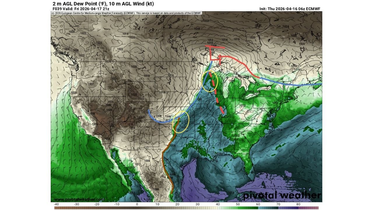
Forecasters are watching a bimodal threat today — two circled areas of slightly stronger tornado focus sitting along and ahead of the cold front and dryline. The broader risk zone for large hail and damaging winds covers an enormous spatial area, meaning communities well outside the two core zones are still firmly in the severe weather picture this afternoon and evening.
States and Cities Facing Direct Threats Today
- Iowa: Des Moines, Davenport, Iowa City — inside the northern yellow-circled tornado focus zone along the cold front
- Illinois: Chicago, Rockford, Peoria, Springfield — in the northern corridor where the cold front and tornado focus overlap
- Kansas: Wichita, Kansas City area, Dodge City — inside the southern yellow-circled tornado focus zone along the dryline
- Missouri: Kansas City, St. Louis, Columbia — between both threat zones with large hail and damaging wind gusts expected
- Oklahoma: Oklahoma City, Tulsa — on the southern edge of the dryline threat corridor watching supercell development
- Nebraska: Omaha and southeast Nebraska communities on the northwestern fringe of the northern threat zone
- Indiana: Fort Wayne, Indianapolis watching storm activity push east through the evening hours
- Wisconsin: Milwaukee, Madison corridor on the far northern edge of the upper storm zone
What Both Zones Are Threatening Today
This is not a single storm event with a clean track. Two separate danger areas are firing simultaneously with different triggers driving each one.
- Northern zone — cold front pushing through Iowa and Illinois with a focused tornado corridor circled by forecasters — large hail and damaging winds widespread across the entire northern storm corridor
- Southern zone — dryline firing across Kansas and Oklahoma with a second distinct tornado focus area — supercells possible ahead of the crashing front with all severe hazards on the table
- Deep low pressure near 1000 hPa sitting between both zones — the engine driving the entire system and keeping both threat areas active simultaneously
- Dew points in the 50s to low 60s across the warm sector from Kansas through Missouri and into Illinois — deep Gulf moisture fueling every storm that fires today
- Large hail and damaging wind gusts covering a very large spatial area across the entire corridor between the two tornado focus zones — no community from Kansas City to Chicago should consider themselves out of the picture today
Why Two Separate Zones Makes This More Dangerous
A single storm line is easier to track and prepare for. When the line passes, the threat largely ends. Today’s bimodal setup is fundamentally different and more dangerous for one specific reason — communities have to watch two separate directions simultaneously.
Kansas City sits almost exactly between the two yellow-circled tornado focus zones on today’s map. Storms from the southern Kansas-dryline zone approach from the southwest. Storms from the northern Iowa-Illinois cold front zone approach from the northwest. Depending on timing and track, Kansas City and Missouri communities could be dealing with severe weather threats from two different storm clusters hours apart — meaning the threat does not end after the first round clears.
Iowa and Illinois sit inside the northern focus zone where the cold front is the primary trigger. The deep low pressure center sitting just east of the front is tightening the pressure gradient and strengthening winds at all levels of the atmosphere — exactly the conditions that support organized supercell tornadoes in the warm sector ahead of the front.
The Dew Point and Moisture Picture
The surface map shows dew points pushing into the green shading — representing readings in the upper 50s to low 60s — flooding northward from the Gulf of Mexico through Texas, Oklahoma, and into Kansas and Missouri ahead of the dryline. That moisture is the fuel that makes every storm that fires today capable of becoming severe quickly.
When surface dew points are this high this far north in April, the available energy in the atmosphere is enormous. Storms tapping into moisture this deep do not struggle to sustain themselves — they intensify rapidly and can maintain large hail, rotation, and damaging winds for extended periods as they track northeast across the threat corridor.
What the Timeline Looks Like Today
Storm development along the southern dryline across Kansas and Oklahoma is expected to begin during the early to mid afternoon as heating peaks and the dryline sharpens. These initial storms will reveal whether discrete supercells can hold together ahead of the cold front or whether the storm mode becomes messier as activity clusters.
The northern cold front zone across Iowa and Illinois fires during the mid to late afternoon as the front pushes east and encounters the deeply unstable warm sector air in place across those states. The evening hours bring the squall line sweeping through Missouri, Indiana, and eventually Tennessee with the damaging wind threat from the linear storm mode.
The full severe weather window today runs from approximately 2 PM through midnight across the entire corridor — a long and exhausting day of active weather for communities from Wichita to Chicago.
What Every Resident Needs to Do Right Now
- Iowa and Illinois communities — be in your safe shelter and weather-aware before 2 PM — the northern tornado focus zone fires during peak afternoon heating
- Kansas and Oklahoma residents — watch the dryline storm development closely from early afternoon and treat any tornado warning with immediate action
- Kansas City and Missouri — prepare for threats from two directions through the afternoon and evening — the threat does not end after one round of storms passes
- Large hail preparations across the entire corridor — move vehicles to covered parking now, from Wichita to Chicago, stones exceeding 2 inches are possible with any supercell today
- Evening and overnight awareness for Indiana and Tennessee — the squall line pushes east after dark bringing damaging wind gusts to communities that may have let their guard down
- Keep weather alerts active on all devices through midnight — the bimodal nature of today’s setup means warnings can come in multiple waves hours apart
From Kansas to Illinois, today demands full attention from every community inside the threat corridor. The atmosphere is loaded, two separate zones are firing, and the window runs from this afternoon well into tonight.
WaldronNews.com will continue tracking both severe weather zones today and provide updates as storms develop, tornado warnings are issued, and conditions evolve across the Central Plains and Upper Midwest through tonight.