
Wisconsin, Iowa and Illinois Brace for Explosive Tornado Threat Today as CAPE Surges Above 5000 and Shear Hits 80 Knots Over Chicago and Milwaukee
MILWAUKEE, Wisconsin — The atmosphere across the Upper Midwest today is being described by forecasters with one word — wild. The combination of instability and wind shear building over Wisconsin, Iowa, and Illinois right now is not just impressive for April — it is impressive for any time of year. And if discrete storms manage to fire into this environment this afternoon, the message from forecasters is simple: watch out.
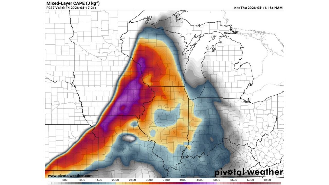
The Mixed-Layer CAPE map valid this afternoon tells the story immediately. A deep purple core — representing atmospheric instability values exceeding 5,000 J/kg — is sitting directly over the Iowa-Wisconsin-Illinois border region. That purple zone does not show up on April maps very often. Paired with bulk wind shear values of 80 to 100+ knots across the same corridor, the atmosphere is loaded with the exact combination that produces violent, long-track tornadoes when discrete supercells can get organized.
Cities and States That Must Be Ready Today
- Wisconsin: Milwaukee, Madison, Janesville, Kenosha, Racine — sitting in the overlap zone of extreme CAPE and extreme shear where the tornado threat is highest
- Iowa: Des Moines, Davenport, Iowa City, Dubuque — inside the deep purple CAPE core that extends across the entire eastern half of the state
- Illinois: Chicago, Rockford, Peoria, Joliet, Aurora — on the eastern edge of the most extreme instability and shear overlap
- Minnesota: Twin Cities metro on the northwestern fringe of the elevated CAPE and shear corridor
- Indiana: Fort Wayne and northwest Indiana watching storm activity push in from the west through the evening hours
- Michigan: Southwest Michigan including Kalamazoo on the far eastern edge as activity spreads toward the Great Lakes
What the Numbers Are Showing Right Now
Both maps together paint one of the most alarming severe weather pictures seen this spring across the Upper Midwest.
- Mixed-Layer CAPE exceeding 5,000 J/kg in the purple core over eastern Iowa and southwestern Wisconsin — extraordinary atmospheric fuel that rivals summer Gulf Coast values, almost unheard of this far north in April
- CAPE values of 3,500 to 4,500 J/kg across a massive area covering all of Illinois, most of Iowa, and southern Wisconsin — the entire region is loaded, not just the bull’s eye
- Bulk shear of 80 to 100+ knots — deep magenta and purple on the shear map covering Iowa, Wisconsin, and northern Illinois — this is the wind shear that keeps supercells organized, rotating, and producing tornadoes for extended periods
- Shear vectors orthogonal to the warm front — the specific orientation that allows discrete storms to stay separated from each other rather than merging into a messy cluster — the single most important factor for violent tornado production today
- Explosive instability and shear combo on the warm front — the warm front itself is a convergence zone where storms fire first and tap into the most extreme atmospheric energy in the entire setup
The One Factor That Determines Everything Today
The instability is there. The shear is there. The moisture is there. The trigger is arriving.
The single factor that determines whether today becomes a historic tornado outbreak or a significant but more manageable severe weather event is storm mode — specifically whether storms can stay as discrete supercells long enough to tap into this extreme environment.
The shear vector being orthogonal — perpendicular — to the front is the most encouraging sign. That specific orientation physically pushes storms apart from each other, giving each supercell its own lane to operate in without merging. When that happens in an environment with 5,000 J/kg CAPE and 80+ knot shear, supercells become self-sustaining violent tornado machines.
Forecasters put it simply — “if that happens, watch out.” That is not hedging language. That is a direct warning from people who spend their careers analyzing these setups that today’s atmosphere has the potential to produce something significant.
Where the Greatest Danger Is Concentrated
The overlap zone on the two maps — where the deepest purple CAPE and the deepest purple shear sit on top of each other — centers over the Iowa-Wisconsin border region and extends south through northern Illinois.
Milwaukee sits on the eastern edge of this maximum overlap zone. Madison is inside it. Rockford is inside it. Davenport and Iowa City are inside the CAPE core. Chicago sits just south and east of the primary overlap but remains firmly inside significant CAPE and shear values that support severe weather.
The warm front lifting northward through the region is the initial trigger line — the first storms to fire along or just ahead of that boundary will immediately encounter the most extreme instability and shear in the entire setup. Those first storms have the best chance of becoming organized discrete supercells before the cold front arrives and forces a mode change.
How the Afternoon and Evening Unfold
Storm development is expected to begin along the warm front across Iowa and southern Wisconsin during the early to mid afternoon as daytime heating peaks. These first storms are the ones to watch most closely — they fire into the maximum energy zone and have the clearest path to supercell organization.
As the afternoon progresses the cold front pushes east, sweeping through Iowa and Illinois and eventually pushing storm activity into Indiana and Michigan through the evening hours. The window when discrete supercells can operate ahead of the cold front — the most dangerous window for violent tornadoes — runs from roughly 2 PM through 8 PM across Wisconsin, Iowa, and Illinois.
After dark, storm activity continues pushing east but the character shifts more toward a squall line with damaging straight-line winds becoming the primary threat for Indiana and Michigan communities through the late evening.
What Residents Across the Upper Midwest Must Do Right Now
- Wisconsin and Iowa residents — be sheltered before 2 PM — the extreme CAPE and shear overlap means any storm that fires this afternoon becomes dangerous almost immediately
- Milwaukee, Madison, Rockford, and Chicago — you are in or immediately adjacent to the maximum threat zone — do not wait for a tornado warning to identify your shelter location
- Turn weather alerts on every device in your household right now — in an environment with 80+ knot shear, storms move fast and warning lead times can be short
- Anyone in a mobile home across Iowa, Wisconsin, or Illinois — identify a sturdy shelter location and plan to be there before afternoon storms develop
- Indiana and Michigan residents — evening and overnight squall line winds are your primary threat — secure outdoor items and be weather-aware through midnight
- Do not let the morning calm fool you — the atmosphere is building silently right now and the change from calm to tornado-warned can happen within 30 minutes of storm initiation this afternoon
When forecasters look at a setup and say “if discrete storms form, watch out” — that is the signal to act now, not when the first warning sounds.
WaldronNews.com will continue tracking today’s explosive severe weather threat across Wisconsin, Iowa, Illinois and the Upper Midwest and provide live updates as storms develop through the afternoon and evening.