
Virginia and Maryland Under Red Flag Warning as Severe Drought Expands 2.66 Inches Below Normal and Fire Risk Hits Critical Levels From Winchester to Harrisonburg
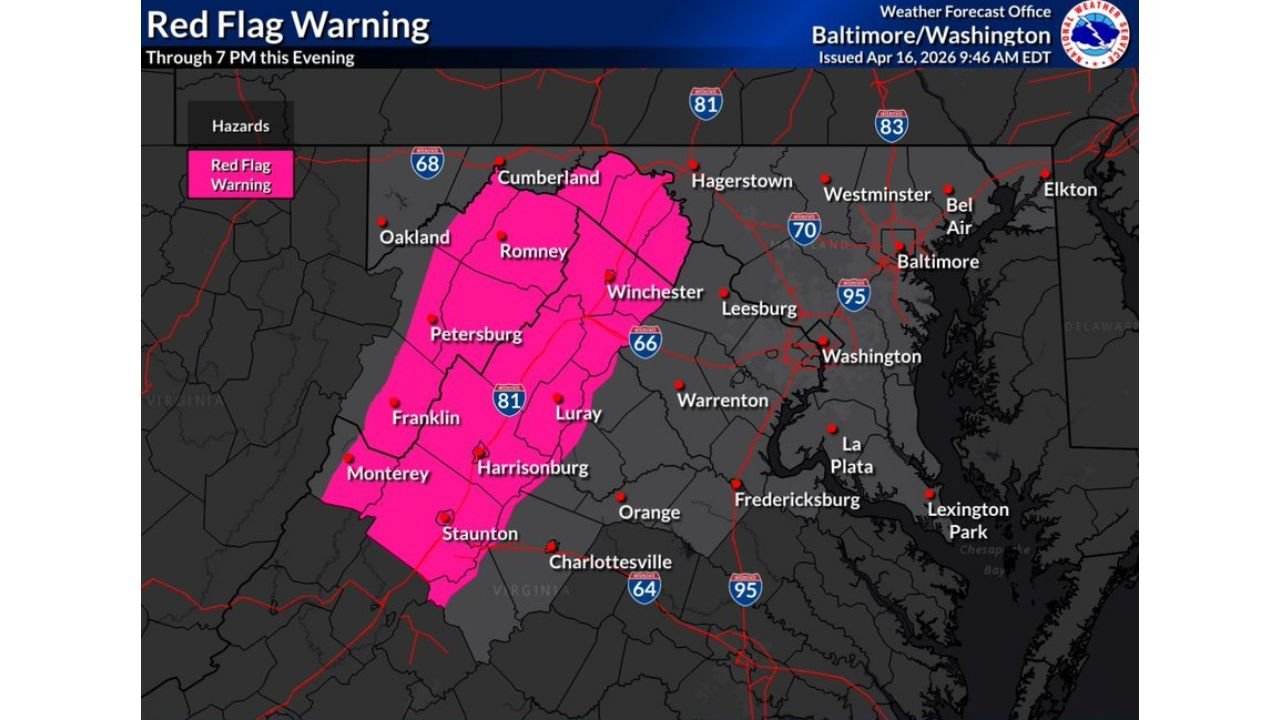
WASHINGTON, D.C. — Severe Drought has officially expanded across southern and eastern portions of the Washington D.C. region, and a Red Flag Warning is in effect right now across western Virginia and parts of Maryland — covering communities from Cumberland down through Winchester, Harrisonburg, Staunton, and Luray — as record heat, low humidity, and dry soils create the most dangerous wildfire conditions seen in the Mid-Atlantic this spring.
The drought situation has deteriorated fast. Just one week ago most of this region was under Moderate Drought. As of Thursday April 16, southern and eastern portions of the D.C. region have jumped one full category to Severe Drought — and the rainfall deficits behind that jump are significant. Since March 1, Reagan National Airport is running 2.25 inches below normal, Dulles International is 1.58 inches below normal, and BWI is sitting at a stunning 2.66 inches below normal. That is not a minor dry spell. That is months of accumulated moisture deficit hitting a landscape that is now tinder dry.
Areas Under Red Flag Warning Right Now
- Virginia: Cumberland, Romney, Winchester — northern Shenandoah Valley under active Red Flag Warning through 7 PM today
- Virginia: Petersburg, Luray, Franklin — central Shenandoah Valley communities in the heart of the critical fire weather zone
- Virginia: Harrisonburg, Staunton, Monterey — southern end of the warning zone where dry soils and gusty winds combine most dangerously
- Maryland: Western Maryland communities along the I-81 corridor included in the warning area
- Virginia: Charlottesville and surrounding areas watching conditions closely just outside the current warning boundary
- Washington D.C. region: The broader metro area under elevated fire risk even outside the formal warning zone due to severe drought and record warmth
What a Red Flag Warning Actually Means
A Red Flag Warning is the highest level fire weather alert issued. It means critical fire weather conditions are either happening right now or will begin very shortly.
- Dry soils across the entire Shenandoah Valley and western Maryland corridor — vegetation and ground cover are parched after months of below-normal rainfall
- Record warmth pushing temperatures well above seasonal norms across the region — warm air accelerates moisture loss from soil and plant material
- Low relative humidity stripping remaining moisture from dry grass, dead leaves, and tree litter — the exact surface fuels that ignite easily and spread fire fast
- Gusty winds occasionally pushing through the region — even modest gusts of 15 to 20 mph can spread a fire dramatically once ignition occurs
- Most flammable conditions concentrated along and west of the I-81 corridor — the zone now under the formal Red Flag Warning through 7 PM
The Drought Picture Across the Region
The Drought Monitor map released Thursday April 16 shows the full scope of how dry the Mid-Atlantic has become.
Severe Drought — the D2 category, two steps above normal dry conditions — now covers the southern and eastern portions of the D.C. region including much of southern Maryland and eastern Virginia. The deeper orange on the map tells the story visually — this is not localized dryness confined to one county. This is a regional drought that has been quietly building since early March and has now crossed into the severe classification.
Moderate Drought covers the northern portions of the region including much of central Maryland and northern Virginia. The only area showing any relief is the far northwestern corner near the West Virginia border where conditions remain abnormally dry but have not yet reached drought status.
The trajectory matters as much as the current status. Going from Moderate to Severe Drought in a single week is a rapid deterioration — and the forecast does not offer much relief. The dry pattern is expected to continue through the next week with only about 0.25 inches of rain possible in the D.C. area — that amount will do little to meaningfully dent the existing moisture deficit or reduce fire risk.
Why the Shenandoah Valley Is Ground Zero
The Red Flag Warning zone covering Winchester, Harrisonburg, Staunton, and the I-81 corridor is not random. The Shenandoah Valley combines several factors that make it particularly vulnerable during drought conditions.
The valley floor and surrounding ridges are covered with dry grassland, open farmland, and forested slopes that have accumulated months of dry fuel. The terrain itself channels and accelerates wind, meaning gusts that seem moderate at a weather station can become much more intense along ridge lines and in valley corridors. The combination of accumulated drought, record warmth, low humidity, and terrain-enhanced winds creates exactly the conditions under which wildfires start easily and spread with alarming speed.
The I-81 corridor running through the heart of the warning zone carries significant traffic daily — and vehicle sparks, cigarette disposal, and equipment use along that corridor represent real ignition risks on a day when the landscape is this dry and the winds are this active.
What Residents Must Do Through 7 PM Tonight
- No outdoor burning of any kind — leaves, brush piles, yard waste — all burning is dangerous today across the entire warning zone
- Dispose of cigarettes properly and completely — dry grass along roadsides can ignite from a single improperly discarded cigarette butt
- Keep vehicles off dry grass — hot exhaust systems and catalytic converters can ignite dry vegetation underneath a parked vehicle
- Avoid any equipment that creates sparks — lawnmowers, chainsaws, grinders, and other outdoor power equipment should not be used today in the warning zone
- Know your local evacuation routes — communities in the Shenandoah Valley near wooded or open land should be aware of how quickly fire can move in these conditions
- Report any smoke or fire immediately — early reporting gives firefighters the best chance of containing a fire before it spreads
What the Next Week Looks Like for Drought Relief
The news on the rainfall front is not encouraging. The forecast through the next week shows only about 0.25 inches of rain possible for the D.C. region — the main chance being Saturday night into Sunday as a cold front brings some showers through the area.
A quarter inch of rain will not break the Severe Drought. It will not meaningfully recharge soil moisture. And it will not eliminate the fire risk that has been building across Virginia and Maryland since early March. Until a more significant and sustained rainfall pattern develops, the drought and the associated fire danger will persist across the region.
Residents across Virginia, Maryland, and the Washington D.C. region should treat the current conditions with full seriousness — the landscape is as dry as it gets, and a single spark in the wrong place today could have severe consequences.
WaldronNews.com will continue monitoring the drought situation and fire weather threat across Virginia and Maryland and provide updates as conditions develop through the weekend and beyond.