
Tennessee and Kentucky Face Gusty Wind Threat Tonight as Severe Storm Complex Targets Clarksville Nashville and Bowling Green by 7 PM
NASHVILLE, Tennessee — A dangerous severe thunderstorm complex is bearing down on Middle Tennessee and southern Kentucky right now, and the leading edge could reach Clarksville, Nashville, and Bowling Green as early as 7 PM tonight. The first severe thunderstorm warning of the evening has already been issued for Stewart County, Tennessee — and the storm system is tracking directly toward the I-24 corridor with gusty damaging winds as the primary threat.
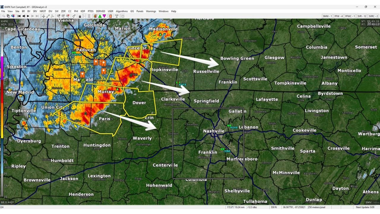
Radar out of Fort Campbell is showing a massive wall of deep red and orange storm cores stretching from Paducah and Princeton, Kentucky southward through Hopkinsville and Paris, Tennessee — a large and organized storm complex moving rapidly to the east-northeast. Three separate storm tracks are visible on radar, all pointing directly toward the Nashville metro area and surrounding communities.
Cities and Counties in the Direct Path Tonight
- Tennessee: Stewart County — already under the first severe thunderstorm warning of the evening as the complex arrives from the northwest
- Tennessee: Clarksville, Dover, Erin, Waverly — directly in the path of the approaching storm complex within the next 1 to 2 hours
- Tennessee: Nashville, Gallatin, Springfield, Franklin, Murfreesboro — in the warning box and watching radar closely as the complex tracks east-northeast
- Kentucky: Bowling Green, Russellville, Hopkinsville — on the northern track of the storm system with severe warnings already in effect to the west
- Kentucky: Paducah, Princeton, Madisonville — already inside active severe weather warnings as the complex pushes east
- Tennessee: Lebanon, Cookeville — on the eastern fringe watching whether the complex maintains intensity as it pushes further east
What the Radar Is Showing Right Now
The storm complex on radar is large, organized, and moving fast.
- Deep red and orange cores from Paducah south through Murray and Paris — the most intense reflectivity values indicating heavy rain, strong winds, and potentially large hail within the complex
- Three separate arrow tracks on the forecast radar all pointing east-northeast — toward Clarksville, directly at Nashville, and toward Bowling Green
- Active severe thunderstorm warnings already issued for multiple counties in western Kentucky and northwestern Tennessee — the warning area is expanding eastward as the complex moves
- Stewart County Tennessee receiving the first severe warning for Middle Tennessee — a direct indicator that the complex is maintaining enough intensity to warrant official warnings as it crosses into the state
- Gusty damaging winds identified as the primary threat from this complex — the squall line structure is capable of producing 60+ mph straight-line wind gusts ahead of and within the heaviest storm cores
The Critical Question for Nashville Tonight
The forecaster note attached to this radar image is honest and important — this complex is expected to weaken the further east it travels. But the key phrase is “whether or not that happens by the time it reaches us.”
That uncertainty is exactly what makes tonight dangerous for Nashville and Middle Tennessee. If the complex maintains its current intensity through Clarksville and into the Nashville metro, residents across Davidson, Sumner, Wilson, and Williamson counties could be dealing with damaging wind gusts and heavy rain during the evening hours. If it weakens as expected before reaching the metro, the threat drops considerably — but nobody will know which scenario plays out until the storms are already arriving.
Nashville should not gamble on the weakening scenario. The complex is large enough, organized enough, and moving fast enough that treating tonight as a serious weather event is the only responsible approach.
The I-24 Corridor — Ground Zero Tonight
The I-24 Special reference in the forecast is significant. The Interstate 24 corridor running from Clarksville through Nashville and southeast toward Murfreesboro sits almost exactly along the primary storm track shown on radar tonight.
This is one of Tennessee’s busiest highway corridors — carrying commuter traffic, long-haul truckers, and evening travelers on a Friday night. Gusty wind events within severe thunderstorm complexes are particularly dangerous for high-profile vehicles on open highway stretches. A sudden 60+ mph wind gust encountering a semi-truck on I-24 between Clarksville and Nashville is a serious safety concern that drivers need to be aware of tonight.
Anyone planning travel along the I-24 corridor in Middle Tennessee or southern Kentucky this evening should monitor conditions closely and be prepared to pull off the road safely if conditions deteriorate suddenly.
Timeline for Tonight’s Threat
The storm complex was located over western Kentucky and northwestern Tennessee as of 5:46 PM with the leading edge tracking rapidly east-northeast.
- By 7 PM — leading edge of the complex reaches Clarksville, Dover, and Hopkinsville if current forward motion holds
- 7 PM to 9 PM — primary window for Nashville, Gallatin, Springfield, and Lebanon to experience the heaviest storm activity
- 9 PM onward — complex continues tracking toward Murfreesboro, Cookeville, and eventually into eastern Tennessee — weakening trend expected but not guaranteed
The entire threat window for Middle Tennessee is compressed into a 2 to 3 hour period this evening — a fast-moving event that will arrive, deliver its worst, and push east relatively quickly.
What to Do Before 7 PM Tonight
- Secure any outdoor furniture, equipment, or items that could become projectiles in 60+ mph wind gusts — do this right now before the storms arrive
- Avoid travel on I-24 between Clarksville and Nashville during the 7 PM to 9 PM window if possible — high wind gusts make highway travel dangerous
- Keep weather alerts active on your phone tonight — the complex is moving fast and warning lead times will be short
- Nashville metro residents — have a safe interior room identified before 7 PM — even a weakening complex can produce damaging wind gusts that break windows and bring down trees
- Monitor radar yourself — with a fast-moving complex like this, watching real-time radar gives you the best situational awareness of exactly when storms will arrive at your location
- Stewart and Montgomery County residents — you are first in line tonight, be sheltered and weather-aware immediately
Middle Tennessee and southern Kentucky are in the active severe weather window right now. Do not wait for the storms to arrive to take action.
WaldronNews.com will continue tracking this severe storm complex across Tennessee and Kentucky and provide updates as warnings are issued and the system moves through the region tonight.