
Iowa, Illinois and Wisconsin Outbreak Update as Kansas and Oklahoma Face Active Tornado Threat Today Saturday April 18
KANSAS CITY, Missouri — The severe weather outbreak that tore through Iowa, Illinois, and Wisconsin on Friday is now being assessed for damage and confirmed tornado reports — while the threat is far from over. Today, Saturday April 18, the same storm system has pushed southeast and a fresh tornado threat is active across Kansas and Oklahoma as the cold front and dryline continue driving dangerous supercell development across the Southern Plains.
Friday’s storm complex produced a long corridor of severe weather stretching from the Upper Midwest all the way through Tennessee and Kentucky — and the atmosphere today is reloading across Kansas and Oklahoma with similar energy levels that made yesterday so dangerous.
Yesterday’s Outbreak Footprint
Friday’s event left a significant mark across multiple states as the storm complex tracked northeast through the region.
- Iowa: Des Moines, Davenport, Iowa City corridor bore the brunt of the initial supercell development during the afternoon hours
- Illinois: Rockford, Chicago, Peoria saw severe storm activity push through during the late afternoon and evening
- Wisconsin: Milwaukee, Madison, Janesville experienced the northern tornado corridor as storms tracked northeast
- Tennessee: Clarksville, Nashville, Stewart County hit by the trailing squall line through the late evening hours
- Kentucky: Paducah, Hopkinsville, Bowling Green dealing with severe thunderstorm warnings through Friday night
The storm complex maintained a semi-discrete structure for an extended period — longer than many forecasters initially expected — due to extremely strong and perpendicular bulk shear vectors keeping storms from instantly merging into a single squall line. That prolonged discrete phase is exactly what gave individual storm cells the time needed to produce rotation and severe impacts across the corridor.
What the Storm Data Shows From Friday Night
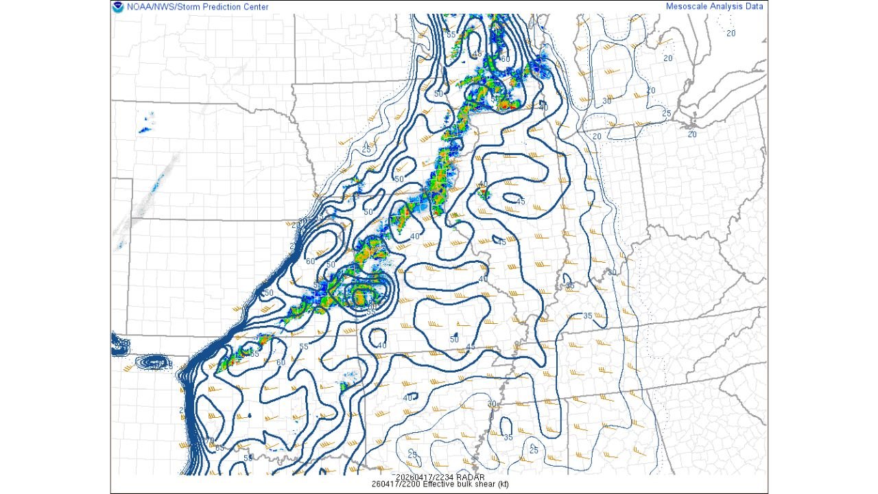
The mesoscale analysis from Friday evening shows the storm corridor stretching from the Iowa-Missouri border all the way northeast through Illinois and into the Great Lakes region — with the most intense radar cores concentrated along the cold front boundary.
Effective bulk shear values of 50 to 60 knots were present along the primary storm corridor Friday evening — more than sufficient to support organized supercell structures and tornado production. The fact that storms maintained semi-discrete character despite multiple mergers and storm interactions confirms the atmosphere was delivering on its dangerous setup through much of the afternoon and evening.
Confirmed tornado reports and full damage assessments from Friday’s outbreak are still being compiled across Iowa, Illinois, and Wisconsin — and the final numbers are expected to be significant given the atmospheric environment that was in place.
Today’s Active Threat Across Kansas and Oklahoma
While the Midwest begins its damage assessment this morning, Kansas and Oklahoma are waking up to their own dangerous setup today.
- Kansas: Wichita, Dodge City, Liberal — in the active threat zone as the dryline sharpens through the afternoon
- Oklahoma: Oklahoma City, Tulsa, Enid, Woodward — directly in the path of supercell development along the cold front-dryline intersection
- Kansas: Eastern Kansas communities watching storm initiation push in from the west through the afternoon hours
- Texas: Northern Texas panhandle on the southern flank of today’s dryline threat
The same cold front responsible for yesterday’s Midwest outbreak has pushed south and east overnight and is now interacting with Gulf moisture streaming northward across Oklahoma and Kansas. The atmosphere across the Southern Plains today carries significant instability and wind shear — the two ingredients that made Friday so dangerous across the north are now in place across the south.
What Today’s Threat Looks Like for Kansas and Oklahoma
Today’s setup across the Southern Plains favors supercell development during the afternoon and early evening hours as daytime heating peaks and the dryline sharpens across western Kansas and Oklahoma.
- Tornado threat — any discrete supercell that fires along today’s dryline has the atmospheric support to produce tornadoes, with the evening low-level jet strengthening providing an additional boost to rotation potential
- Large hail — stones exceeding 2 inches in diameter are possible with the strongest supercells across Kansas and Oklahoma today
- Damaging winds — the squall line following behind discrete supercells will sweep damaging gusts through Missouri and Arkansas through the evening hours
- Peak threat window — 2 PM to 9 PM across Kansas and Oklahoma with the most dangerous period during the late afternoon and early evening
What Both Days Together Tell Us
Friday and Saturday together are shaping up to be one of the most significant two-day severe weather stretches of the 2026 spring season across the Central United States.
Friday targeted the Upper Midwest — Iowa, Illinois, Wisconsin — with a tornado corridor that forecasters had been tracking all week. Today the same system targets the Southern Plains — Kansas and Oklahoma — in a second round that carries its own serious threat level.
Communities that have already been through severe weather in the past 24 hours should not let that experience create complacency. Today’s storms across Kansas and Oklahoma are a completely fresh threat with their own independent severe weather potential.
What to Do Right Now This Saturday
- Kansas and Oklahoma residents — treat today as a full severe weather day, be weather aware before 2 PM and have shelter plans confirmed
- Iowa, Illinois, and Wisconsin residents — assess any damage from Friday carefully before the next weather system arrives later this coming week
- Wichita, Oklahoma City, and Tulsa — you are the cities most directly in today’s threat zone, keep weather alerts active all afternoon and evening
- Missouri and Arkansas — squall line winds are your primary threat today as storm activity pushes east through the evening hours
- Anyone traveling across Kansas or Oklahoma today — know where the nearest sturdy shelter is along your route and monitor conditions before departing
The Central United States is in the middle of one of the most active severe weather stretches of the spring. Two days, two regions, and the atmosphere is not finished yet.
WaldronNews.com will continue tracking today’s severe weather threat across Kansas and Oklahoma and provide full updates on Friday’s outbreak damage reports as confirmed numbers become available.