
Washington D.C. Shatters 81 Year Old Heat Record Today With 12 Days at 80 Degrees Before Temperatures Plunge to 38 by Tuesday
WASHINGTON, D.C. — Washington D.C. is making history today, Saturday April 18, and not in a subtle way. Today marks the 12th day in 2026 with a high temperature of 80 degrees or higher in the nation’s capital — breaking a record that has stood since 1945 when the city reached that milestone 11 times by this date. On average, D.C. does not even reach 12 days of 80-degree heat until around May 22 — meaning the city just hit a mid-May benchmark more than a month early.
And then comes the brutal reversal. By Monday and Tuesday, the same city that is shattering heat records today will be shivering through highs of 59 and 38 degrees — a temperature crash of nearly 50 degrees in just three days that will feel like stepping from summer directly into early winter.
The 10-Day Temperature Rollercoaster for D.C.
The forecast chart tells one of the most dramatic weather stories of the spring in the Mid-Atlantic region.
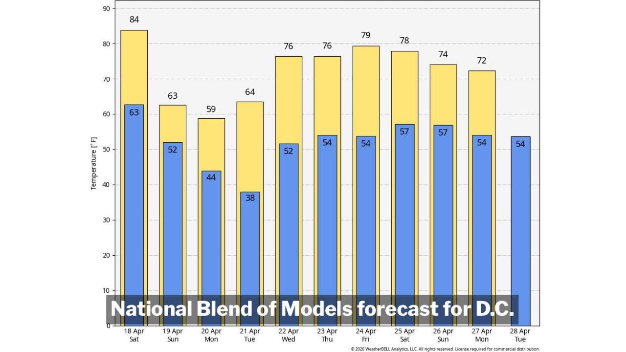
- Today Saturday April 18 — 84 degrees high, 63 degrees low — record-breaking heat, the 12th day at 80+ this year, surpassing the 1945 all-time early season record
- Sunday April 19 — 63 degrees high, 52 degrees low — the cold front arrives and temperatures begin crashing hard
- Monday April 20 — 59 degrees high, 44 degrees low — the chill deepens, jacket weather replacing the weekend heat
- Tuesday April 21 — 38 degrees low — the coldest night of this stretch, frost and freeze concerns for areas outside the Beltway as temperatures drop to near-freezing
- Wednesday April 22 — 76 degrees high — the atmosphere bounces back with another warm push
- Thursday April 23 — 76 degrees high, 54 degrees low — warm pattern briefly returns
- Friday April 24 — 79 degrees high — summer warmth making another appearance
- Saturday April 25 — 78 degrees high — second warm weekend in a row possible
- Sunday April 26 through Tuesday April 28 — highs in the 72 to 74 degree range — warm but slowly moderating
Why Today’s Record Matters
The previous record of 11 days at 80 degrees or higher by this date was set in 1945 — over 81 years ago. That record has survived every warm spring since then, through multiple record-setting years and notable heat events across the Mid-Atlantic. Today’s 12th day at 80 or above erases it entirely.
What makes this even more remarkable is the seasonal context. Washington D.C. typically accumulates its 12th day of 80-degree heat around May 22. Today is April 18. The city has essentially compressed an entire month of normal heat accumulation into the first weeks of April — driven by a persistent warm pattern that kept temperatures elevated well above normal throughout the month.
Today’s 84-degree high adds one final exclamation point to the record before the cold front arrives and ends the streak dramatically.
The Brutal Cold That Follows
The same cold front responsible for severe weather across Kansas and Oklahoma today is pushing east and will arrive in Washington D.C. by Sunday. The temperature crash it delivers to the Mid-Atlantic is one of the sharpest seen this spring.
Sunday drops to a high of just 63 degrees — a 21-degree single-day crash from today’s record heat. By Monday the high struggles to reach 59 degrees. And Tuesday night brings the coldest conditions of the entire stretch — a low of 38 degrees that puts frost and freeze concerns on the table for suburban and rural communities outside the Beltway across Virginia and Maryland.
Anyone who planted warm-season garden plants during the recent heat needs to act before Sunday evening. Tomatoes, peppers, basil, and other warm-season plants left unprotected through Tuesday night could be damaged or killed by near-freezing temperatures.
The Pattern Beyond Tuesday
After the cold punch of Monday and Tuesday, the atmosphere across D.C. does not stay cold for long. Wednesday bounces back to 76 degrees and the warm pattern reasserts itself through the end of April — with highs in the 72 to 79 degree range from Wednesday April 22 through Saturday April 25.
The forecast suggests D.C. could add more 80-degree days next week as well, though those are not yet locked in with certainty. If they verify, the city’s already remarkable 2026 heat record extends even further beyond the previous benchmark.
The overall picture for late April is a warm one — but the cold snap arriving Sunday through Tuesday is a sharp and serious interruption that the region needs to be fully prepared for before tonight ends.
What D.C. Area Residents Should Do Before Sunday
- Enjoy today’s record warmth — but have a plan for the temperature crash arriving tomorrow
- Cover or bring in any warm-season garden plants Sunday evening — Tuesday’s 38-degree low is cold enough to damage or kill unprotected plantings
- Pull out layers and jackets — Monday and Tuesday will feel shockingly cold after weeks of heat, especially with wind making temperatures feel even colder
- Watch for frost advisories Monday night and Tuesday night — especially for Virginia and Maryland communities outside the urban core of Washington D.C.
- Check back mid-week — the warm pattern returning Wednesday through the weekend could push D.C. toward more record territory if temperatures climb back to 80
Washington D.C. is living through a historically warm April — and today’s broken record proves it. But spring in the Mid-Atlantic always has one more cold surprise left, and this one arrives in less than 24 hours.
WaldronNews.com will continue tracking the temperature pattern across Washington D.C. and the Mid-Atlantic and provide updates through the cold snap and beyond.