
Iowa and Wisconsin Tornado Emergency Now as Severe Warned Storms With Large Hail and Strong Tornadoes Strike Dubuque Dyersville and Monticello This Afternoon
DUBUQUE, Iowa — Severe thunderstorm warnings are already active and tornado warnings are on the ground right now across eastern Iowa and into southwestern Wisconsin as a rapidly developing and dangerous storm cluster explodes along a confluence boundary this afternoon. The storms firing near Dubuque, Dyersville, Monticello, and Anamosa are growing fast — and any discrete storm that develops in the open environment between this cluster and the approaching cold front is capable of producing very large hail and strong to intense tornadoes through this afternoon and evening.
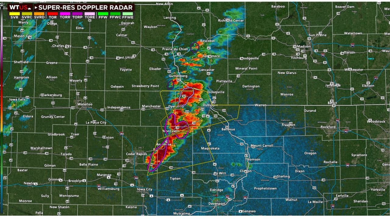
This is a live and rapidly evolving severe weather situation. Radar is showing deep red and purple cores — the most intense reflectivity values possible — centered directly over the Dubuque metro area and tracking northeast toward southwestern Wisconsin. Tornado warning polygons in magenta and purple are already active over this corridor right now.
Cities Under Active Warnings This Afternoon
- Iowa: Dubuque — sitting directly under the most intense storm core with active tornado warning in effect right now
- Iowa: Dyersville, Monticello, Anamosa — inside severe warning polygons with tornado possible from the rotating storm cluster
- Iowa: Cedar Rapids corridor watching storm development to the northeast as the cluster grows upscale
- Wisconsin: Prairie du Chien, Boscobel, Fennimore, Dickeyville — in the direct northeast track of the storm cluster with warnings expanding into the state
- Wisconsin: Dodgeville, Platteville on the eastern edge of the warning zone as storms push toward Madison
- Iowa: Bellevue, Maquoketa, Clinton on the southeastern flank watching additional storm development
- Illinois: Freeport, Rockford on the far southeastern edge as storm activity pushes toward the state line
What Radar Is Showing Right Now
The Super-Res Doppler Radar image from this afternoon is one of the most alarming of the entire outbreak.
- Deep red and purple radar cores directly over Dubuque and Dyersville — reflectivity values indicating extremely intense precipitation, large hail, and powerful updrafts
- Multiple active warning polygons stacked on top of each other — SVR severe thunderstorm warnings, TOR tornado warnings, and TORE tornado emergency level signatures all visible simultaneously over the same area
- Purple tornado warning polygon covering Monticello and Anamosa — the highest priority warning color indicating confirmed or strongly indicated tornado on the ground
- Storm cluster growing upscale — the individual cells are merging into a larger and more organized system, increasing the damaging wind threat significantly as the afternoon progresses
- Large gap between this storm cluster and the cold front — that open real estate ahead of the front is sitting in a highly favorable severe weather environment, meaning any new discrete storm that fires in that zone has a direct path to producing strong and intense tornadoes
The Most Dangerous Part Is Still Coming
What is happening over Dubuque and Dyersville right now is serious — but forecasters are pointing to what comes next as potentially even more dangerous.
There is a significant area of open atmosphere between the current storm cluster and the approaching cold front. That gap is filled with the same extreme CAPE and 60+ knot wind shear that made Friday’s setup so alarming all week. Any discrete supercell that manages to develop in that favorable environment — away from the upscale growing cluster — will immediately have access to the full atmospheric fuel load.
Those discrete storms, if they fire, are capable of producing very large hail and strong to intense tornadoes without much warning time. The afternoon heating hours through approximately 7 PM represent the window when this scenario is most likely to play out across eastern Iowa, southwestern Wisconsin, and northwestern Illinois.
STP Values Confirm the Danger
The Significant Tornado Parameter map from Friday afternoon shows the full scope of the tornado-supporting environment in place across this corridor. Deep purple STP values — the highest possible readings — are centered exactly over eastern Iowa and southwestern Wisconsin where the current storms are firing.
STP values above 1.0 indicate an environment highly favorable for tornado production. The values showing on this map across the Cedar Rapids to Dubuque to Madison corridor are running well above that threshold — confirming that the atmosphere is delivering exactly what forecasters feared all week for this region.
What to Do If You Are in Eastern Iowa or Southwestern Wisconsin Right Now
- If you are in Dubuque, Dyersville, Monticello, or Anamosa — take shelter immediately — active tornado warnings are in effect for your area right now, do not wait
- Interior room, lowest floor, away from all windows — get there now and stay until the warning expires
- Prairie du Chien, Boscobel, and Fennimore Wisconsin — the storm is tracking directly toward you, be in your shelter location before it arrives
- Do not go outside to look at the storm — rotating wall clouds and tornado debris can be invisible inside heavy rain wrapping around a supercell
- Cedar Rapids and Iowa City — watch radar closely, new storm development in the favorable environment to your north and east could fire quickly and track toward your communities
- Anyone on the road in eastern Iowa right now — pull off and find a sturdy building immediately, do not try to outrun a tornado warning in a vehicle
The severe weather situation across eastern Iowa and southwestern Wisconsin is active, dangerous, and evolving rapidly right now. Every minute matters.
WaldronNews.com is tracking this tornado threat live across Iowa and Wisconsin and will provide updates as warnings are issued and storm reports come in through the afternoon and evening.