
Iowa and Minnesota Face Imminent Tornado and Large Hail Threat This Afternoon as STP Hits 4.3 Near Mason City and Storms Fire Along the Cold Front
DES MOINES, Iowa — The cap is breaking. Convective initiation is beginning right now across parts of Iowa and Minnesota along the cold front and in the open warm sector — and the environment already in place is more than capable of producing strong to intense tornadoes, very large hail, and damaging winds as discrete storms fire into one of the most dangerous atmospheric setups of the entire 2026 spring season.
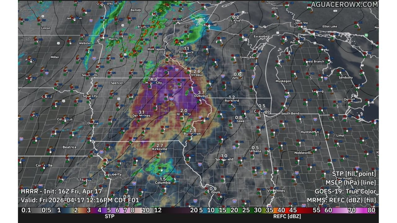
The Significant Tornado Parameter values on radar right now say everything. An STP value of 4.3 is showing near Mason City, Iowa — that is not a borderline number. That is a number that forecasters associate with violent, long-track tornado events. The bull’s eye of the most dangerous environment stretches from Mason City south through Des Moines and east through Dubuque and Iowa City — and storms are beginning to fire into it right now.
Cities and States in the Immediate Threat Zone
- Iowa: Mason City — sitting directly under the 4.3 STP maximum, the single most dangerous point in the entire setup right now
- Iowa: Des Moines, Iowa City, Dubuque — inside the deep purple STP zone with values of 2.0 to 3.7 — all well above the threshold for violent tornado production
- Iowa: Burlington, Kirksville corridor — 2.1 to 2.7 STP values indicating a highly favorable tornado environment extending into southern Iowa
- Wisconsin: Viroqua, Dubuque border area — 2.6 to 3.7 STP showing the threat extending northeast into southwestern Wisconsin
- Minnesota: Minneapolis area on the northern edge watching storm initiation along the cold front boundary
- Illinois: Rockford, Chicago on the eastern fringe — 0.5 to 1.2 STP values still above the concerning threshold
- Missouri: Columbia, Kirksville on the southern edge of the active tornado parameter zone
What the Sounding Data Is Showing Right Now
The atmospheric sounding valid this afternoon near the Iowa-Minnesota border is one of the most alarming profiles of the entire outbreak.
- Surface CAPE of 3,391 J/kg — extreme atmospheric fuel already in place at the surface level
- DCAPE of 1,053 — the downdraft energy that drives the most destructive straight-line winds in severe storms
- 3CAPE of 80 — the explosive low-level energy index running at a level that supports the most violent and rapid storm intensification
- Critical Angle of 79 degrees — approaching the ideal 90-degree orientation that maximizes tornado production from any supercell that fires
- SigSvr value of 54,383 — an extraordinary number that reflects how all the dangerous ingredients are stacking together simultaneously
- Effective Layer STP of 10+ — the Effective Layer Significant Tornado Parameter is pegged at the top of the scale, with the possible hazard type flagged directly as TOR — tornado
- Probability of EF2+ tornado with supercell: 78% — nearly 8 in 10 chance that any supercell firing in this environment produces a significant tornado rated EF2 or stronger
- Storm Relative Helicity of 292 m²/s² at the 0-3km level — the rotational energy available in the lower atmosphere is extraordinary
- Effective Shear of 66 knots — more than sufficient to sustain organized, long-lived supercells through the afternoon and evening
Why Mason City Is the Bullseye Right Now
The 4.3 STP value sitting over Mason City, Iowa right now is the highest value visible on the entire regional map. That number represents the perfect overlap of every ingredient needed for violent tornado production — moisture, instability, shear, and helicity all maximized in the same location at the same time.
Mason City and the surrounding Cerro Gordo County communities are directly in the most dangerous zone on this map. Any storm that fires near Mason City this afternoon and manages to stay discrete — away from the larger upscale cluster — will immediately tap into that 4.3 STP environment and has the atmospheric support to produce a violent, long-track tornado rated EF2 or higher.
The STP values remain dangerously high south through Des Moines at 3.1, east through Dubuque at 3.7, and into Iowa City at 2.0. The entire eastern half of Iowa is sitting in tornado parameter values that would be considered extreme on any severe weather day — not just in April.
The Cap Is Breaking — What Happens Next
The slight delay in storm initiation this morning due to lingering capping actually made the atmosphere more dangerous — not less. The cap suppressed early storm development, allowing surface heating to continue building instability and the atmosphere to load even more energy into the warm sector.
Now that the cap is weakening with daytime heating and stronger ascent along the cold front, the storms that fire will immediately encounter that fully loaded atmosphere. The first discrete supercells to initiate in the open warm sector — particularly near Mason City and the Iowa-Minnesota border — will have the best chance of tapping the maximum STP values before any storm mergers or upscale growth can interfere.
The window for the most dangerous discrete supercell activity runs from now through approximately 8 PM across Iowa and Wisconsin. After that, storm mergers and the advancing cold front will shift the primary threat toward a more linear damaging wind event pushing into Illinois and Indiana.
What Every Resident Across Iowa Must Do Right Now
- Mason City and Cerro Gordo County — the 4.3 STP value over your community means any storm that fires nearby has a near-certain path to tornado production — be sheltered and ready now
- Des Moines residents — 3.1 STP directly over your city is not a drill number, have your shelter identified and weather alerts active before afternoon storms develop
- Dubuque and Iowa City — you are inside the highest STP zone in the state, treat any tornado warning issued this afternoon as an immediate life-safety emergency
- Wisconsin communities near Viroqua and the Iowa border — the 2.6 to 3.7 STP values extend into your area, watch radar closely through the evening
- Anyone in a mobile home across eastern Iowa — leave now and get to a sturdy shelter before the first storm fires, do not wait for a warning
- Illinois and Indiana residents — monitor the situation through the evening as the squall line pushes east with damaging winds after the supercell phase ends
A 78% probability of EF2+ tornadoes from any supercell in this environment is not a number that leaves room for casual response. The atmosphere across Iowa and Minnesota is delivering on everything forecasters warned about this week.
WaldronNews.com is tracking this tornado emergency live across Iowa, Minnesota, and Wisconsin and will provide continuous updates as storms fire, warnings are issued, and the situation evolves through tonight.