
Indiana Braces for 50 mph Wind Gusts and Lightning Before Sunrise Saturday as Strong Storms Target Indianapolis Fort Wayne and Kokomo at 3 AM
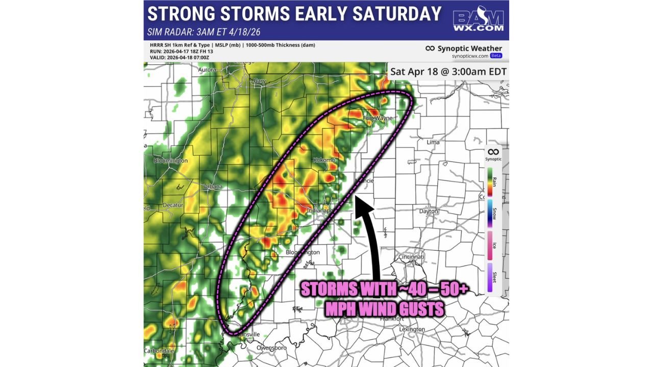
INDIANAPOLIS, Indiana — Indiana residents need to set a weather alert before going to bed tonight. A line of strong storms carrying wind gusts of 40 to 50 mph and lightning is forecast to sweep across the state in the early morning hours of Saturday April 18, with simulated radar showing the storm complex arriving near the Indianapolis area around 3 AM Eastern Time.
This is the trailing edge of the same massive storm system that produced tornado warnings and severe weather across Iowa, Wisconsin, and Illinois on Friday. By the time it reaches Indiana, the tornado threat has diminished — but the damaging wind gusts and dangerous lightning remain very real hazards for communities from Fort Wayne down through Indianapolis, Kokomo, Bloomington, and into Evansville.
Indiana Cities in the 3 AM Storm Path
- Indiana: Fort Wayne — on the northern end of the storm corridor, one of the first major cities the complex reaches in the early morning hours
- Indiana: Kokomo — sitting inside the dashed pink storm zone showing the highest wind gust potential on the forecast radar
- Indiana: Indianapolis — directly in the path of the storm complex at approximately 3 AM Eastern with wind gusts and lightning expected
- Indiana: Muncie, Anderson — in the northeastern portion of the wind threat zone as storms push through central Indiana
- Indiana: Bloomington — on the southern end of the primary storm corridor watching activity push through during the pre-dawn hours
- Indiana: Evansville — on the far southern edge as the storm line continues tracking east and south through the overnight
- Illinois: Urbana, Decatur on the western edge already seeing storm activity pushing through ahead of the main Indiana threat
What 3 AM Storms Mean for Indiana Residents
The timing of this storm complex makes it particularly dangerous — and particularly easy to sleep through.
- 40 to 50 mph wind gusts — strong enough to bring down tree limbs, knock out power lines, and cause property damage across a wide area from Fort Wayne to Evansville
- Dangerous lightning — the storm complex is producing active lightning across the corridor, a serious risk for anyone caught outside in the pre-dawn hours
- 3 AM arrival at Indianapolis — most residents will be asleep when the strongest winds hit, meaning the damage happens before anyone realizes the storms have arrived
- Widespread storm corridor — the dashed pink zone on the forecast radar covers a large north-to-south swath of Indiana, meaning no single track shift puts communities out of range
Why Overnight Storms Are More Dangerous
Daytime severe weather is dangerous enough — but overnight storms carry an additional layer of risk that daylight events do not.
When 40 to 50 mph wind gusts arrive at 3 AM, trees that are already saturated from spring rains fall onto homes and power lines without any warning. Power outages occur while families are asleep and unaware. Downed lines in the dark are invisible hazards. And without active weather alerts on a phone or weather radio, many residents will sleep straight through the event and wake up to damage they never anticipated.
Indianapolis specifically sits at the center of the storm zone on tonight’s forecast radar. The city and surrounding Marion County communities — Carmel, Fishers, Greenwood, Lawrence — are all inside the wind threat corridor for the 3 AM window.
The Bigger Picture for Indiana Tonight
Tonight’s storm complex is the final chapter of a two-day severe weather event that began Friday afternoon across the Upper Midwest and has been tracking steadily east ever since.
Iowa and Wisconsin dealt with tornado warnings and significant supercell activity Friday afternoon and evening. Tennessee and Kentucky faced the squall line through Friday night. Now Indiana receives the trailing wind event in the early morning hours of Saturday — weaker than what the states to the west experienced, but still capable of producing power outages, downed trees, and property damage across a wide footprint.
After the storms push through Indiana by Saturday morning, the system continues east into Ohio and Kentucky through the early afternoon before weakening further over the Appalachians.
What Indiana Residents Should Do Before Bed Tonight
- Turn weather alerts ON for your phone before you go to sleep — this is the single most important action you can take tonight, a 3 AM storm will not wake you up unless your phone does it first
- Bring in any outdoor furniture, decorations, or loose items that 50 mph wind gusts could turn into projectiles before the storms arrive
- Check on outdoor pets and animals — make sure they have proper shelter before the overnight hours
- Know where your flashlight is — power outages from downed lines are the most likely outcome from tonight’s wind gusts across Indianapolis, Fort Wayne, and Kokomo
- If you wake up to a weather alert at 3 AM — move away from windows immediately until the storm passes, then check for any damage outside once it is fully light and safe
- Fort Wayne and Kokomo residents — you are in the highest wind threat zone on tonight’s forecast, take precautions seriously before bed
Indiana gets the overnight chapter of this outbreak tonight. Set your weather alerts, secure what is outside, and let your phone do the watching while you sleep.
WaldronNews.com will continue tracking tonight’s storm complex across Indiana and provide updates on damage reports and power outages as Saturday morning arrives.