
Illinois Tornado Emergency Now as Dangerous QLCS Line Producing Embedded Tornadoes and 70 mph Winds Slams Pontiac Bloomington and Decatur
BLOOMINGTON, Illinois — A tornado emergency is unfolding across central Illinois right now. A violent QLCS squall line is tearing through the state producing multiple embedded tornadoes and wind gusts of 60 to 70 mph — and the storm is not weakening. Active tornado warnings in magenta are stacked across a corridor from Ottawa and Pontiac south through Bloomington, Decatur, and Lincoln as the dangerous line continues pushing east toward Indiana.
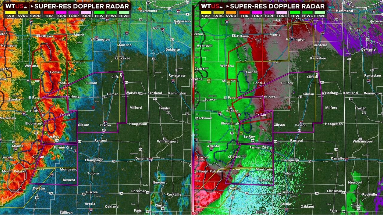
Radar is showing one of the most alarming signatures of the entire outbreak. The velocity scan on the right side of the dual-panel radar image shows deep red slamming directly into deep purple across Bloomington and Pontiac — that extreme color contrast is the radar signature of violent rotation within the squall line. Multiple tornado warning polygons in bright magenta are active simultaneously across central Illinois right now.
Illinois Cities Under Active Tornado Warnings This Moment
- Illinois: Pontiac — inside active tornado warning with rotation detected on radar right now
- Illinois: Bloomington, Normal — directly in the path of the rotating QLCS line with magenta tornado warnings active
- Illinois: Decatur — tornado warning polygon covering the city as the line pushes southeast
- Illinois: Lincoln, Mount Pulaski — in the southern portion of the active warning corridor
- Illinois: Eureka, El Paso, Fairbury — tornado warnings active across McLean and Livingston counties
- Illinois: Farmer City, Clinton — watching the line approach from the northwest with warnings expanding
- Illinois: Champaign, Rantoul on the eastern edge — tornado warnings pushing toward your communities next
- Indiana: Danville, Hoopeston, Kentland — directly in the path as this dangerous line pushes east into Indiana within the next 30 to 60 minutes
What the Radar Is Showing Right Now
The dual-panel Super-Res Doppler Radar image is one of the most serious of the entire two-day outbreak.
- Deep red reflectivity cores — the left panel shows intense storm cores from Ottawa all the way south through Decatur — a continuous wall of severe weather spanning more than 100 miles of Illinois
- Extreme velocity couplets — the right panel velocity scan shows violent red-to-purple contrast directly over Bloomington and Pontiac — the radar signature of embedded tornadoes rotating within the squall line
- Multiple simultaneous magenta tornado warning polygons — covering Pontiac, Bloomington, Decatur, Lincoln, and surrounding counties all at the same time
- Red tornado warning boxes — additional warnings stacked below the magenta polygons indicating the continuous nature of the rotating threat along the entire line
- Line extending from Ottawa to south of Decatur — over 150 miles of active severe weather moving as a single organized system pushing east-northeast
Why QLCS Tornadoes Are So Dangerous
A QLCS — Quasi-Linear Convective System — is a squall line that produces tornadoes very differently from classic supercells. These embedded tornadoes are notoriously difficult to detect and warn for because they spin up suddenly, often last only minutes, and can be hidden inside heavy rain wrapping around the line.
The key warning from forecasters right now — “the further the line gets from the radar, the harder detection becomes, but that doesn’t mean the tornado threat is waning.” That is a direct message to communities ahead of this line that just because there may not be a warning issued for your exact county does not mean a tornado is not possible. QLCS tornadoes can touch down with little to no warning time.
The 60 to 70 mph straight-line wind gusts embedded throughout this line add another layer of danger — even in areas where a tornado does not touch down, the straight-line winds are strong enough to cause significant structural damage, bring down trees and power lines, and create dangerous driving conditions across central and eastern Illinois.
The Line Is Headed Straight for Indiana
Communities in western Indiana need to be sheltered and ready right now. This line is not stopping at the state border.
Danville, Hoopeston, Kentland, and Rensselaer in Indiana are directly in the path of this system and will begin experiencing the leading edge of the squall line within the next 30 to 60 minutes. The tornado production capability does not automatically shut off when the line crosses from Illinois into Indiana — the same embedded rotation threat follows the line east.
Lafayette, Crawfordsville, and eventually Indianapolis are all in the extended path of this system through the evening and overnight hours.
If You Are Ahead of This Line Right Now — Do This Immediately
- If you are in Bloomington, Decatur, or Lincoln — you are in an active tornado warning area right now — take shelter immediately in an interior room on the lowest floor away from all windows
- Do not wait to see the tornado — QLCS tornadoes are rain-wrapped and invisible until they are directly on top of you
- Champaign and Rantoul — your tornado warning is minutes away, be sheltered before the line arrives
- Danville and western Indiana — you have 30 to 60 minutes — use that time to get to your shelter now, not when the warning sounds
- Anyone driving on I-55, I-74, or I-72 in central Illinois — pull off immediately and get inside a sturdy building — do not try to outrun this line
- Do not go back outside until the entire line has passed and all warnings have expired — QLCS lines produce multiple tornadoes in succession and the threat does not end with one rotation passing
This is an active, life-threatening severe weather emergency across central Illinois. The line is long, the tornadoes are embedded and hard to detect, and the winds are violent.
WaldronNews.com is tracking this tornado emergency live across Illinois and Indiana and will provide continuous updates as the dangerous line pushes east through tonight.