
Colorado Snowfall Hits Denver Golden and Evergreen as April Storm Drops Up to 5.3 Inches Across the Metro Area
DENVER, Colorado — While Illinois and Indiana are dealing with tornadoes and Kansas faces severe storms, Colorado is waking up to a completely different weather story this weekend — April snow blanketing the Denver metro area and surrounding foothills with totals already ranging from 2.6 inches in Aurora up to 5.3 inches in the higher terrain west of the city.
Snow reports are coming in across the entire Denver-Boulder corridor this morning, confirming that the same cold system driving severe weather across the Central Plains is delivering a late-season snow punch to Colorado communities from Longmont in the north all the way south through Evergreen, Golden, and the Denver International Airport area.
Where Snow Has Fallen Across the Denver Metro
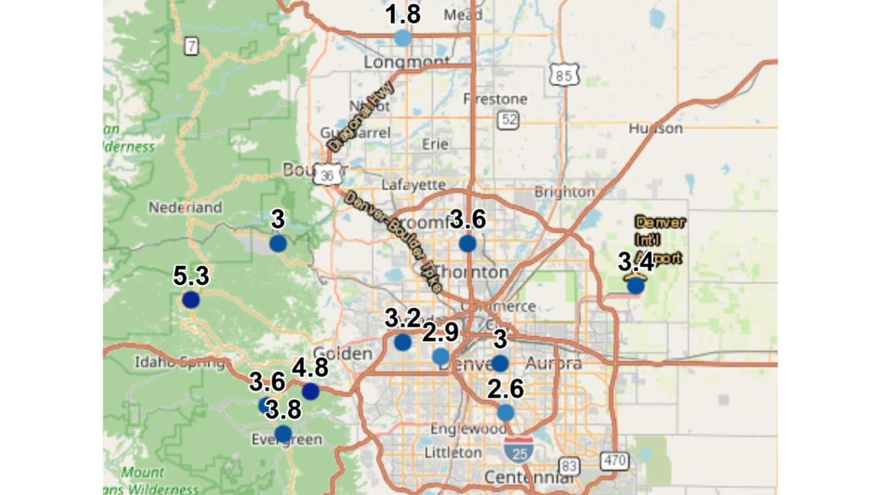
- Colorado: Foothills west of Denver — 5.3 inches reported in the higher terrain near Nederland and Idaho Springs corridor — the heaviest totals of the event
- Colorado: Evergreen area — 3.8 inches reported with nearby locations showing 3.6 and 4.8 inches across the immediate Evergreen community
- Colorado: Golden — 4.8 inches just west of the city making for slick and hazardous road conditions on area highways
- Colorado: Broomfield and Thornton — 3.6 inches reported along the Denver-Boulder Highway corridor
- Colorado: Denver city proper — 3.2 and 2.9 inches reported across different parts of the metro with 3 inches near Aurora
- Colorado: Denver International Airport — 3.4 inches on the ground raising flight delay concerns for Saturday travelers
- Colorado: Aurora and south metro — 2.6 inches on the southern end of the storm footprint
- Colorado: Longmont and north — 1.8 inches on the northern fringe of the snow corridor
What This Means for Saturday Travel
The snow totals across the Denver metro are significant enough to create real travel problems on Saturday morning — particularly on elevated roadways, bridges, and the mountain passes west of the city.
Denver International Airport with 3.4 inches of accumulation is the number that matters most for anyone with Saturday travel plans. Snow on the ground at DIA combined with continued overnight accumulation means flight delays and cancellations are a serious possibility throughout the morning. Travelers should check their flight status before heading to the airport.
Road conditions on I-70 westbound into the mountains are the other major concern. The foothills west of Denver picked up the heaviest totals — the 5.3 inch report near Nederland and readings of 3.6 to 4.8 inches around Evergreen and Golden indicate significant snow accumulation on mountain approach roads. Chain laws or traction requirements may be in effect on mountain passes this morning.
The Denver-Boulder Turnpike corridor running through Broomfield and Thornton with 3.6 inches means even the flat suburban commuter routes are snow-covered and slick for anyone needing to travel Saturday morning.
April Snow in Colorado — Not Unusual But Still Disruptive
Colorado residents know that April snow is not rare — the state’s history is full of significant late-season storms, and the Denver metro has experienced some of its biggest snowfalls on record during April. The 2026 winter across Colorado was notable for its lack of significant snowfall through January — making this April event feel even more striking to residents who watched a dry winter come and go.
The same cold air mass responsible for the 38-degree temperatures forecast for Washington D.C. by Tuesday is responsible for what Colorado is seeing this weekend — a deep cold trough digging into the Central United States that brings winter to the mountains while also fueling severe weather across the Plains where warm and cold air collide.
Evergreen and the foothills communities southwest of Denver typically see the heaviest snowfall in events like this because of their elevation advantage. The 4.8 inch reading near Golden and the 3.8 inch report from Evergreen are consistent with how this terrain interacts with eastward-moving cold systems — squeezing additional moisture out of the atmosphere as air rises over the foothills.
What Saturday Looks Like Going Forward
Snow accumulation will continue tapering off through Saturday morning as the cold system pushes east and moisture decreases across the Colorado front range. Road treatment crews have been working through the overnight hours but accumulation on secondary roads and elevated surfaces will remain a hazard through the morning commute.
The foothills and mountain communities west of Denver will see the slowest clearing — Nederland, Evergreen, and Idaho Springs area roads should be treated as winter driving conditions through at least Saturday midday.
By Saturday afternoon temperatures should begin recovering enough to melt snow off flat surfaces in the Denver metro, though shaded areas and north-facing roads may remain slick into the early evening hours.
What Denver Metro Residents Should Do This Saturday Morning
- Check DIA flight status before driving to the airport — 3.4 inches on the ground means ground operations are affected and departure delays are possible
- Slow down on all elevated surfaces and bridges — these freeze first and remain slick longest even after flat road surfaces begin clearing
- Avoid I-70 mountain travel until conditions are confirmed clear — the foothills picked up 4 to 5 inches and mountain pass conditions may be significantly worse at elevation
- Give extra stopping distance on suburban roads — 3 inches of snow on Broomfield and Thornton roads means braking distances are significantly longer than dry conditions
- Check on elderly neighbors — April snow events catch people off guard after weeks of mild weather and older residents may need assistance with walkways and vehicles
Colorado’s late April snow is a reminder that winter does not officially surrender in the Rockies until well into May. Saturday morning demands winter driving awareness even as spring severe weather erupts just a few hundred miles to the east.
WaldronNews.com will continue tracking weather conditions across Colorado and the Central United States and provide updates as the storm system moves east through the weekend.