
Kansas and Oklahoma Face Widespread Severe Weather Including Wichita and Oklahoma City Saturday May 16 as Warm Sector Sets the Stage Across the Central Plains
OKLAHOMA CITY, Oklahoma — A severe weather outlook has been introduced for Saturday, May 16, 2026, targeting a corridor from central Kansas into north Texas, with Wichita, Kansas and Oklahoma City, Oklahoma sitting directly in the heart of the threat zone.
An expansive warm sector is expected to be in place across the southern and central Plains by Saturday, setting the stage for widespread severe weather across the region. The risk area is expected to expand and shift in subsequent outlooks as the forecast becomes clearer later this week.
Where the Threat Is Focused
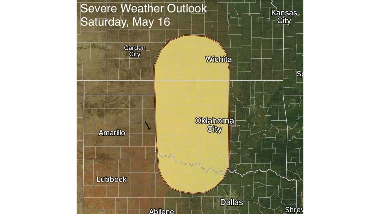
The Severe Weather Outlook for Saturday, May 16 shows a Marginal Risk zone covering a large north-to-south corridor across Kansas and Oklahoma:
- Wichita, Kansas sits near the northern end of the highlighted risk zone and will be among the first communities in the threat area to see storm development Saturday.
- Oklahoma City, Oklahoma falls directly within the core of the outlined severe weather zone, where the warm sector will be most pronounced and storm coverage is expected to be widespread.
- Dallas, Texas sits on the southern fringe of the outlook area, with the threat zone extending into north Texas as the system pushes southward through Saturday.
- Garden City, Kansas and Amarillo, Texas sit just outside the western edge of the current risk zone, though forecasters note the area is likely to expand in coming days.
- Lubbock, Texas and Abilene, Texas are currently outside the outlined threat area but should monitor updates closely as the risk zone is expected to shift before Saturday.
What Is Driving This Setup
A warm sector, which is a region of warm and humid air ahead of an approaching cold front, is the primary fuel source for this Saturday, May 16 severe weather setup:
- Warm sectors across the southern and central Plains in mid-May are among the most dangerous setups in the country for severe thunderstorm and tornado development, as they bring together the ingredients needed for supercell thunderstorms capable of producing violent tornadoes, very large hail and damaging winds.
- The expansive nature of this particular warm sector means storm coverage could be widespread across Kansas and Oklahoma rather than isolated, increasing the overall threat to communities like Wichita and Oklahoma City.
- This outlook is still 4 days away and confidence in exact storm placement, timing and intensity will increase significantly as Wednesday and Thursday forecasts are issued.
Risk Area Expected to Expand
Forecasters have specifically noted that the current risk area will likely expand and shift in subsequent outlooks, and additional days may be added to the severe weather risk as the pattern becomes clearer:
- Residents in Kansas and Oklahoma communities currently outside the outlined zone, including areas near Garden City and Lubbock, should not assume they are in the clear and should monitor forecast updates daily through the week.
- The Friday, May 15 severe weather potential that forecasters have already been tracking for the Midwest and central Plains may combine with this Saturday, May 16 setup to create a multi-day severe weather event across the region.
What to Do Before Saturday
Residents across Wichita, Oklahoma City, Dallas and surrounding communities have several days to prepare before this system arrives:
- Ensure weather alert notifications are active on your phone now so any watches or warnings issued Saturday reach you immediately regardless of what you are doing.
- Have a shelter plan ready at home, work and for any outdoor events planned for Saturday, May 16, as widespread severe weather could develop at any point during the day.
- Check forecast updates daily through Friday as storm timing, threats and the expanded risk area will become much clearer by mid-week.
WaldronNews.com will continue tracking this developing severe weather outlook across Kansas and Oklahoma including Wichita and Oklahoma City and will provide updates as the risk area, storm timing and threats develop ahead of Saturday, May 16.