
Kansas, Oklahoma, Nebraska and Illinois Face Major Tornado and Severe Storm Outbreak in Late May as Pattern Mirrors Dangerous 2004 Season Across the Great Plains and Great Lakes
KANSAS CITY, Missouri — The final 10 days of May are shaping up to bring a significant uptick in severe weather and tornado potential across the Great Plains through the Great Lakes region as peak season finally arrives. A textbook trough-ridge pattern setting up across the United States is expected to ignite an active severe weather stretch in late May into June, with ensemble guidance and atmospheric teleconnections both pointing toward a 2004-style blossoming of the Great Plains tornado season.
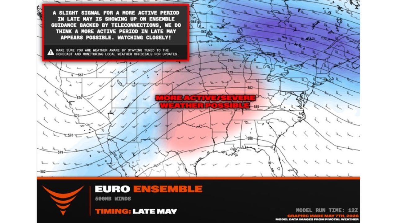
What the Pattern Shows for Late May
Euro Ensemble 500mb wind analysis valid late May shows:
- A strong trough digging into the western United States — the blue shading indicating below-normal heights across the Pacific Northwest and Rockies
- A pronounced ridge building across the eastern United States — the red shading indicating above-normal heights that will act as a blocking feature
- The clash zone between the trough and ridge positioned directly over the central Great Plains and Great Lakes corridor — precisely where tornado and severe weather ingredients concentrate during peak season
- A slight but meaningful signal for a more active period showing up on ensemble guidance backed by teleconnection patterns
Why the 2004 Comparison Matters
The 2004 tornado season across the Great Plains was marked by a dramatic mid-to-late May acceleration in tornado activity after a relatively quiet start to the year. A similar trough-ridge setup drove multiple significant tornado outbreaks across Kansas, Oklahoma, Nebraska and South Dakota through late May and into June. Forecasters watching the current pattern see enough similarities in the large-scale atmospheric setup to raise the possibility of a comparable outbreak sequence developing across the same geography starting in the last 10 days of May 2026.
Who Should Be Watching Closely
- Great Plains states including Kansas, Oklahoma, Nebraska and South Dakota sit in the primary zone where the trough-ridge clash will focus severe weather energy
- Great Lakes region including Illinois, Indiana, Ohio and Michigan fall within the broader active pattern where tornado and large hail events become increasingly likely
- Missouri and Iowa sit at the intersection of both zones and face elevated risk throughout the late May window
- The signal is described as slight but present — meaning confidence is not yet high enough for specific outbreak dates but high enough that preparation should begin now
What This Means Before Late May Arrives
- Review your tornado shelter plan now before the pattern activates — knowing where to go before warnings are issued saves critical seconds
- Check that weather alert systems are working on your phone, NOAA weather radio and local TV app
- Stay tuned to local weather forecasts daily through the last 10 days of May as the pattern becomes clearer and specific threat days come into focus
- The signal is still early — ensemble guidance can shift, but teleconnection backing gives this pattern more credibility than a single model run
WaldronNews.com will continue monitoring the late May severe weather pattern across the Great Plains and Great Lakes and will provide updates as specific threat days become clearer through the coming week.