
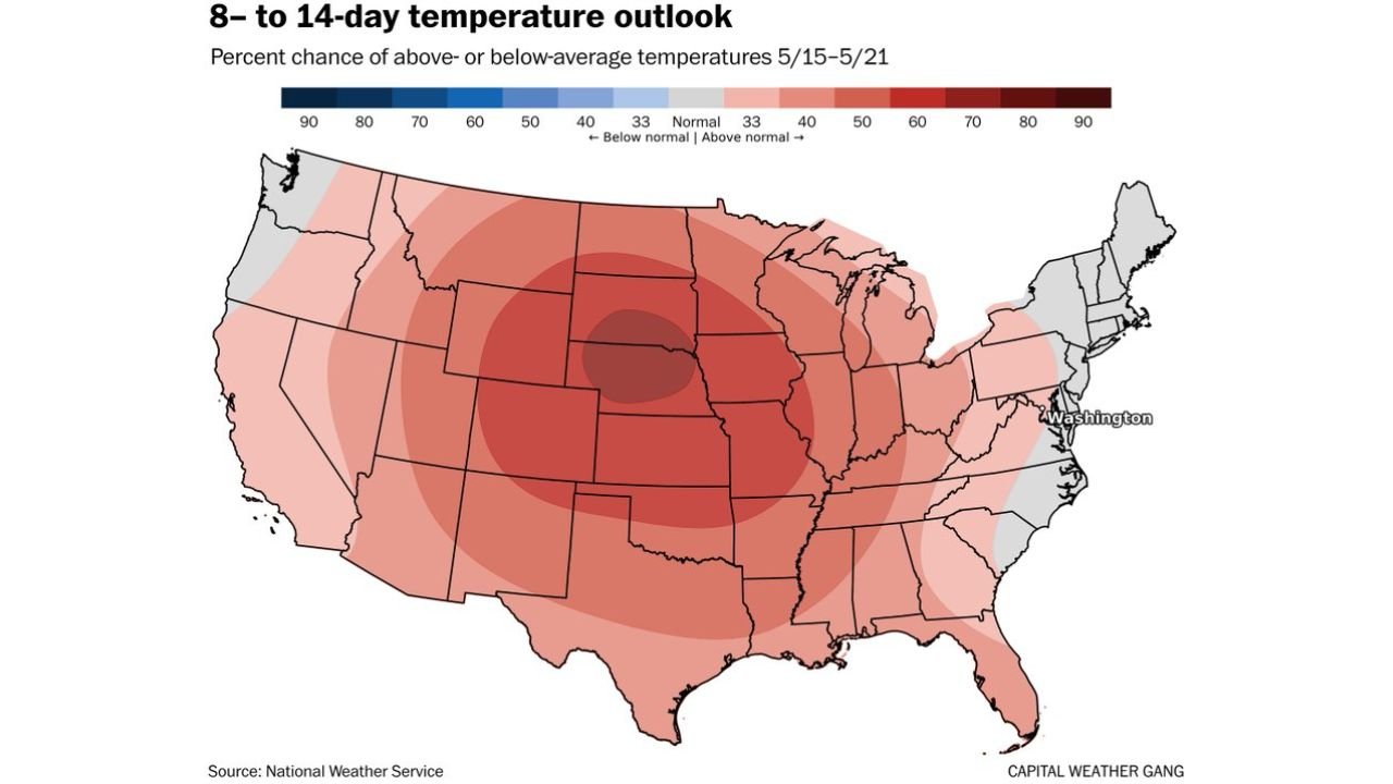
Nebraska, Kansas, Iowa and Illinois Face 70 to 80 Percent Chance of Above-Average Temperatures May 15 Through May 21 as Warmup Spreads Across the Entire Country
WASHINGTON, D.C. — After running 2.6 degrees below average for the month through yesterday, Washington D.C. and much of the eastern United States are headed toward a significant warmup that is expected to sustain longer than recent brief warm spells. Another cooldown early next week will temporarily pull temperatures lower before a seasonably strong high pressure system migrates east mid-month and drives above-average warmth across most of the country from May 15 through May 21.
Who Faces the Highest Warmup Probability
The 8 to 14 day temperature outlook valid May 15 through May 21 shows the following probabilities of above-average temperatures:
- Nebraska, Kansas and Iowa core zone: 70 to 80 percent chance of above-average temperatures — the darkest red bullseye centered over the central Plains
- Colorado, Wyoming, South Dakota and Missouri: 60 to 70 percent chance of above-average temperatures
- Illinois, Indiana, Michigan and Ohio: 50 to 60 percent chance of above-average temperatures
- Texas, Oklahoma, Arkansas and Tennessee: 50 to 60 percent chance of above-average temperatures
- Washington D.C., Virginia and the Mid-Atlantic: 40 to 50 percent chance of above-average temperatures — the warm signal reaches the East Coast but with lower confidence
- Pacific Northwest including Oregon and Washington: near normal to slightly below — the only zone not leaning clearly above average
What Is Driving the Pattern Shift
- A toasty and seasonably strong high pressure system is forecast to migrate eastward through mid-May and continue doing so through late May
- Washington D.C. has been mostly cooler than normal for the past two weeks — the upcoming warmup represents a significant pattern reversal
- The next warmup after early next week’s cooldown is expected to be more sustained than the brief warm periods seen in recent weeks
- The high pressure migration east is expected to continue through late May, meaning the warmth is not a one-day event but a multi-week shift
What This Means for the Plains Drought
For Kansas, Nebraska, Iowa and Colorado already running well below normal on rainfall through the 10-day period, a 70 to 80 percent probability of above-average temperatures arriving May 15 through May 21 directly accelerates drought conditions. Above-normal heat evaporates soil moisture faster, stresses newly planted crops and pushes already dry conditions deeper into drought territory. The combination of the near-term dry pattern and the mid-May heat signal creates a compounding problem for top corn and wheat producing counties across the central Plains.
What to Watch Through May 21
- Nebraska and Kansas face the strongest heat signal of any state in the country during this period — residents and farmers should prepare for temperatures running noticeably above normal through the third week of May
- Washington D.C. and the Mid-Atlantic will finally see relief from the two-week cool stretch but the warmup arrives gradually rather than all at once
- Early next week brings one more cooldown before the sustained warmup takes hold — do not mistake the brief cool period for a continuation of the below-normal pattern
- The late May tornado pattern being watched across the Great Plains will interact directly with this warming trend as increased instability becomes available once moisture returns to the region
- Monitor daily forecasts closely as the high pressure track through mid-May will determine exactly how warm and how quickly the warmup arrives for each region
WaldronNews.com will continue tracking the mid-May warmup and its impact on drought conditions across the Plains and will provide updates as the pattern shift develops through the coming week.