
Indiana and Illinois Face 30 to 40 mph Wind Gusts and Small Hail This Evening as Storms Push Through Indianapolis, Kokomo and Urbana Thursday Night
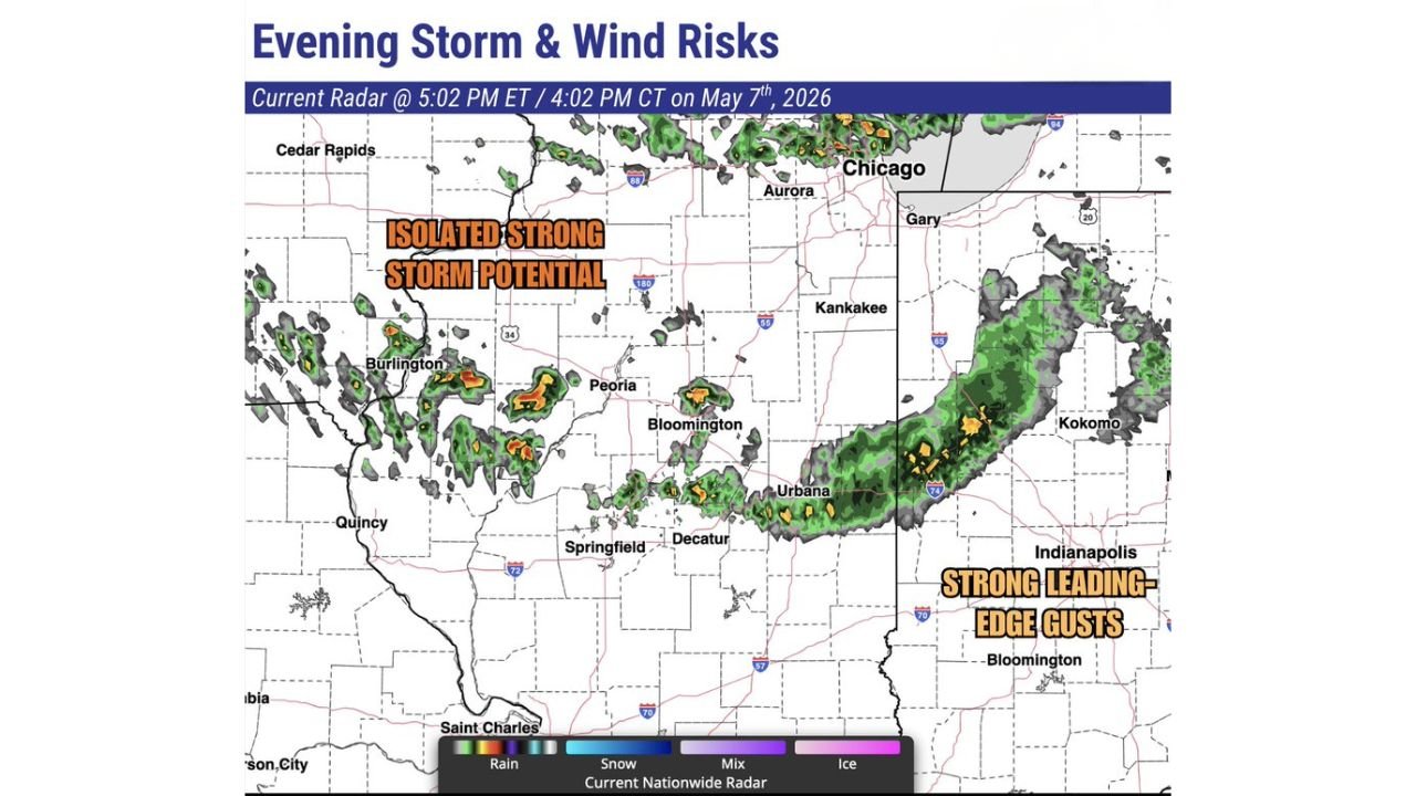
INDIANAPOLIS, Indiana — A rain system pushing through Indiana and Illinois this evening carries two distinct risks for residents across the region. Widespread rain approaching central Indiana will likely bring 30 to 40 mph wind gusts along the leading edge, while scattered storms trailing through central Illinois hold the potential for a couple of stronger cells capable of small hail and gusty winds. The radar at 5:02 PM ET on May 7, 2026 showed the system actively moving through the corridor from Burlington and Peoria through Urbana and into the Indianapolis and Kokomo area.
Two Separate Risk Zones Tonight
Zone 1 — Central Indiana: Strong Leading-Edge Gusts
- Indianapolis, Kokomo and the surrounding central Indiana corridor face the most immediate wind threat
- The leading edge of the widespread rain line is producing 30 to 40 mph gusts as it pushes east
- This is not a severe thunderstorm threat but wind gusts at this speed are strong enough to down small branches and cause isolated power outages
Zone 2 — Central Illinois: Isolated Strong Storm Potential
- Peoria, Bloomington, Urbana and Decatur sit in the zone where scattered precipitation trailing behind the main line holds the potential for stronger individual storms
- Main risks: 30 to 40 mph wind gusts and small hail
- Storms in this zone will be isolated rather than widespread
What the Radar Showed at 5:02 PM
- Burlington through Peoria corridor: Scattered intense cells with orange and red cores indicating heavier rainfall and stronger updrafts
- Urbana and Decatur area: Active cells with elevated intensity moving northeast
- Gary, Kokomo and the Indiana corridor: The leading rain line pushing through with the strongest gusts concentrated along the front edge
- Chicago and Aurora: Rain beginning to push into the southern suburbs
What to Watch This Evening
- Central Indiana residents should expect gusty winds between 30 and 40 mph as the leading rain edge passes — secure any outdoor furniture, patio items or unsecured objects before the line arrives
- Central Illinois residents near Peoria, Bloomington and Urbana should monitor individual storm cells for small hail and gusty winds through the early evening hours
- This is not a tornado or major severe weather event — the primary concerns are wind gusts and small hail with the stronger cells
- Drivers should be alert to reduced visibility in the heavier rain cores and possible debris on roads from wind-snapped branches
WaldronNews.com will continue tracking evening storm and wind risks across Indiana and Illinois and will provide updates as the system moves through the region tonight.