
Kansas, Oklahoma, Nebraska and Texas Drought Worsens Through May 17 as Above-Average Temperatures Bake the Plains While Eastern Half of the Country Turns Cooler
WICHITA, Kansas — The next 10 days will bring a sharp split across the United States, with cooler than normal conditions settling across the eastern half of the country while the Plains, Southwest and Rockies bake under above-average temperatures that will directly worsen an already serious drought. Severe weather activity will remain fairly limited across the Plains during this period, but the drought is expected to accelerate as above-normal heat and below-normal rainfall combine through May 17, 2026.
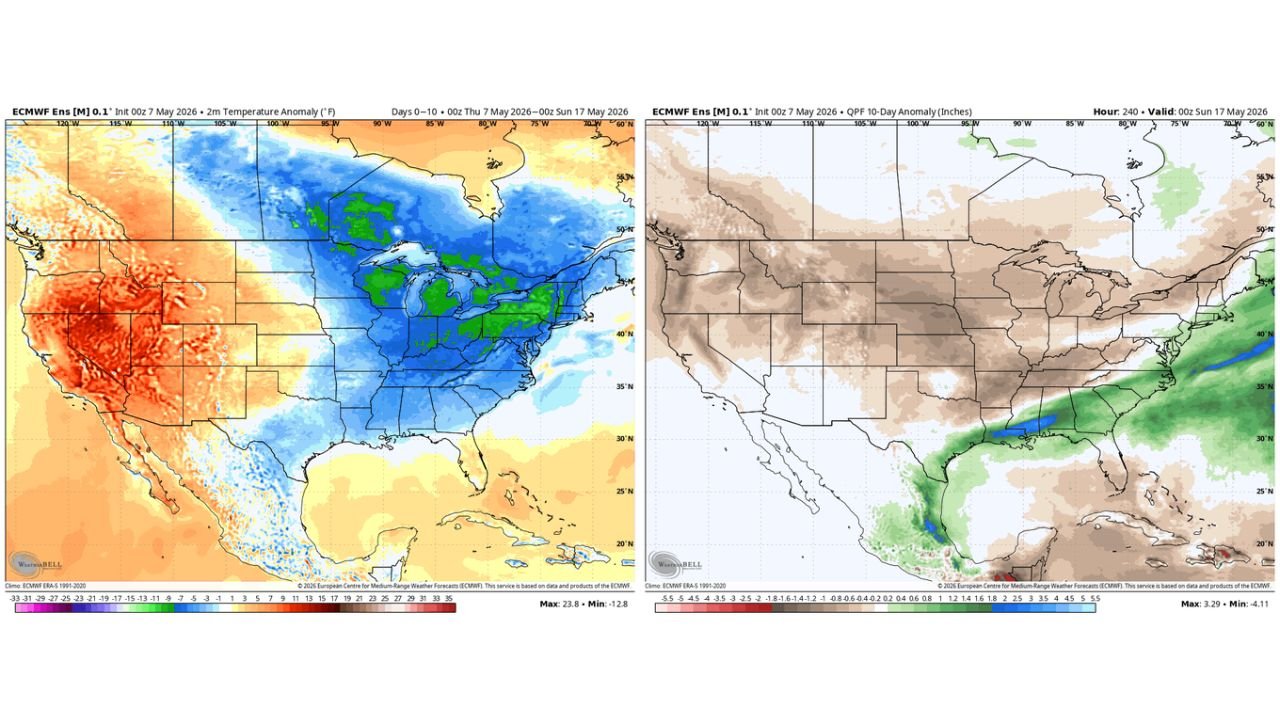
Temperature Outlook Through May 17
The 10-day temperature anomaly forecast shows a dramatic contrast:
- Western United States including California, Nevada, Utah, Colorado and New Mexico: Running 23 to 35 degrees above normal — deep red and orange shading across the entire western third of the country
- Great Plains including Kansas, Oklahoma, Nebraska and Texas: Above normal temperatures continuing to fuel drought conditions and soil moisture loss
- Eastern United States including the Great Lakes, Ohio Valley, Mid-Atlantic and New England: Running 11 to 25 degrees below normal — strong cold air outbreak keeping the eastern half significantly cooler than average through mid-May
- Gulf Coast and parts of the Southeast: Remaining closer to normal and retaining some moisture access unlike the rest of the country
Rainfall Outlook Through May 17
The 10-day precipitation anomaly forecast tells an equally stark story:
- Plains states including Kansas, Oklahoma, Nebraska, Colorado, Wyoming and the Dakotas: Running 0.4 to 1.8 inches below normal — the entire brown zone covering the agricultural heartland of the country
- Southwest and Rockies: Also well below normal with continued dry conditions
- Great Lakes and Midwest: Below normal rainfall despite the cooler temperatures
- Gulf Coast corridor including Louisiana, Mississippi and southern Alabama: The only area seeing above-normal precipitation with a slight positive anomaly
- Southeast Atlantic coast and Mid-Atlantic: Small pockets of above-normal rainfall along the immediate coastline
What This Means for the Plains Drought
The combination of above-average temperatures and well-below-normal rainfall through May 17 creates the worst possible scenario for drought recovery across Kansas, Oklahoma, Nebraska and Texas. Heat accelerates soil moisture evaporation while the absence of rainfall prevents any replenishment. Farmers heading into the critical early growing season window will see drought conditions deepen rather than ease over the next 10 days, with the top corn and wheat producing counties across the region facing compounding stress.
The Gulf Coast and Southeast remain the only zones where moisture is available, but that pattern does not extend far enough north or west to benefit the drought-stricken Plains in any meaningful way during this 10-day window.
What to Watch Through May 17
- Kansas, Oklahoma and Nebraska farmers should prepare for continued soil moisture losses as heat and dry conditions persist through the middle of May
- The eastern cool pattern brings no drought relief to the Plains — cooler air in Ohio and Michigan does not translate to rainfall in Kansas and Oklahoma
- Fire danger will remain elevated across the southern Plains where dry, warm and windy conditions will combine during this period
- The late May pattern shift being watched by forecasters remains the earliest realistic opportunity for Plains drought relief — the next 10 days offer little hope of improvement
- Gulf Coast residents from Louisiana through Alabama can expect continued above-normal rainfall while the rest of the country stays dry
WaldronNews.com will continue tracking drought conditions and the 10-day weather pattern across the Plains and will provide updates as the forecast evolves through mid-May.