
Kentucky, Tennessee, Arkansas and Mississippi Face Major Severe Weather Return in Early May as North Florida Temps Soar to Mid 90s
NASHVILLE, Tennessee — Two major weather headlines are colliding across the Southeast heading into early May — and both demand attention. Kentucky, Tennessee, Arkansas, and Mississippi are facing major episodes of severe weather returning through the first week of May, while at the same time North Florida is staring down mid-to-upper 90s temperatures with little to no rainfall on the horizon as drought conditions intensify.
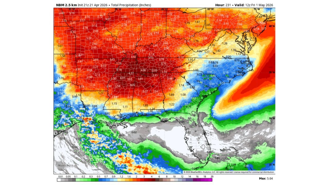
The rainfall map through May 1 tells the story in stark contrast: the Mid-South is drowning in 3 to 5 inches of precipitation while Florida sits bone dry — the green and blue moisture completely cutting off at the state line.
States in the Crosshairs Through May 1
The setup splits the Southeast into two completely different weather stories:
- Kentucky: Louisville and Lexington corridor sitting inside the 3 to 4 inch rainfall zone with severe weather episodes returning
- Tennessee: Nashville and Memphis facing multiple rounds of strong to severe storms through early May — rainfall totals of 3.5 to 4.5 inches forecast
- Arkansas: Little Rock corridor in the 3.5 to 4.0 inch precipitation zone with active severe weather pattern
- Mississippi: Jackson and Tupelo inside the 3.0 to 4.0 inch rainfall area as severe systems roll through repeatedly
- Alabama: Birmingham and Huntsville picking up 3.5 to 4.9 inches — continuing the active severe pattern already defined for Monday April 27
- North Florida: Jacksonville, Gainesville, and Tallahassee — near zero rainfall through May 1 while temperatures push toward mid-to-upper 90s
Primary Threats — Two Very Different Dangers
The pattern creates two distinct and serious threats simultaneously:
- Major severe weather episodes returning to Kentucky, Tennessee, Arkansas, and Mississippi — multiple rounds of organized severe storms through early May with all threats on the table including tornadoes, large hail, and damaging winds
- Mid-to-upper 90s in North Florida — temperatures that forecasters believe may actually be under-forecast given how dry the soil and atmosphere will be; 95°F or higher becomes increasingly possible in Gainesville, Tallahassee, and Jacksonville in early May
- Extreme fire danger continuing in Florida — upper 90s combined with zero rainfall and drought-stressed vegetation creates the most dangerous wildfire conditions of the entire season so far
- Flooding potential in the Mid-South — 3 to 5 inch totals over already-stressed soils across Tennessee and Mississippi could produce flash flooding between severe weather episodes
Why This Pattern Is So Dangerous for Both Regions
Nashville, Tennessee and the broader Mid-South corridor are entering a period of repeated severe weather that mirrors the most active spring weeks already seen across the Plains this year. The pattern delivering 3 to 5 inches of rainfall through May 1 is not doing so gently — these totals come from organized storm systems, meaning the rain arrives in intense bursts during severe weather episodes rather than gentle soaking rains.
For Kentucky and Tennessee, multiple rounds of severe weather means multiple days of tornado, hail, and wind threats over a short period. Communities that take a hit from Monday’s system then face the possibility of another significant event just days later — before recovery and cleanup from the first event are even complete.
Mississippi and Arkansas sit in the zone where the rainfall totals are highest — the deep red and orange on the precipitation map covering 4 to 5 inches across parts of both states. That amount of rainfall in a drought-stressed region sounds beneficial on the surface, but when it arrives primarily through severe thunderstorm activity, flooding becomes a serious secondary threat alongside the storm dangers themselves.
Meanwhile North Florida is experiencing the exact opposite problem. The moisture that is fueling the Mid-South severe weather is completely bypassing the Florida Peninsula. Forecasters are flagging that temperature models are probably under-forecasting how hot North Florida will get — because the models do not fully account for how much extra heat builds when the ground is as parched as it currently is across Florida. Dry soil heats up faster and holds more heat than moist soil, meaning mid-to-upper 90s are increasingly possible across North Florida in early May even before summer officially arrives. That heat combined with zero rainfall and drought-stressed vegetation makes wildfire danger the dominant threat for Florida through the first week of May.
Multi-Day Pattern
The active severe weather pattern for Kentucky, Tennessee, Arkansas, and Mississippi runs through at least May 1 with multiple system passages expected. Each system brings its own severe weather window — Monday April 27 is already defined, and additional threats follow in the days after. For Florida, the dry and increasingly hot pattern holds through at least the same timeframe, with the drought showing no signs of meaningful relief until potentially mid-May at the earliest.
What to Watch Next
- Severe weather watch and warning issuances for Tennessee, Kentucky, and Mississippi through the first week of May
- Whether any individual storm system produces a major tornado outbreak across the Mid-South
- North Florida high temperature records as 90s heat builds through early May
- Red flag warning issuances for North Florida as upper 90s and zero rainfall combine
- Flash flood potential across Tennessee and Mississippi where 4 to 5 inch totals arrive through severe storm activity
Residents across Tennessee, Kentucky, Arkansas, and Mississippi need to stay weather-aware through the first week of May — this is an extended active severe weather period, not a single event. And across North Florida, the message is the opposite but equally urgent: extreme heat and critical fire danger are building, and meaningful rain relief remains weeks away.
WaldronNews.com will continue tracking the Mid-South severe weather pattern and Florida’s dangerous heat and drought and provide updates as each system develops.