
Models Completely Missed the Wind Setup That Produced Multiple Strong and Violent Tornadoes Near Hammond, Louisiana Wednesday Evening
HAMMOND, Louisiana — The weather models failed significantly on Wednesday evening across the Hammond, Louisiana corridor, missing the actual low-level wind shear by a dramatic margin and directly contributing to why multiple strong and violent tornadoes occurred in an area where the forecast suggested a much lower threat. The observed winds from the Hammond radar site showed a completely different atmosphere than what models had predicted just hours earlier.
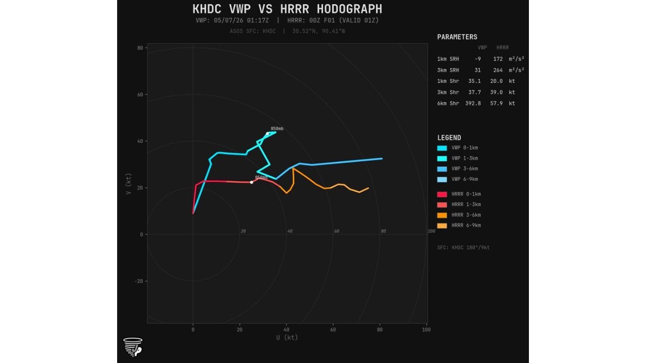
What the Models Said vs What Actually Happened
The KHDC Hammond radar Velocity Wind Profile compared against the 00z model forecast valid at the same time tells the story clearly:
1km Storm-Relative Helicity:
- Model forecast: 172 m2/s2
- Observed: -9 m2/s2 — the model placed helicity nearly 180 degrees off in direction at the lowest level
3km Storm-Relative Helicity:
- Model forecast: 264 m2/s2
- Observed: 31 m2/s2 — model overstated the 3km helicity by more than eight times
1km Wind Shear:
- Model forecast: 20.0 knots
- Observed: 35.1 knots — actual low-level shear ran 75 percent stronger than forecast
3km Wind Shear:
- Model forecast: 39.0 knots
- Observed: 37.7 knots — this level verified reasonably close
6km Wind Shear:
- Model forecast: 57.9 knots
- Observed: 392.8 knots — the most dramatic miss of the entire dataset, with observed upper shear running at nearly seven times the model forecast value
Why This Matters for What Happened Wednesday Night
The hodograph comparison shows the observed wind profile in blue extending dramatically further and higher than the model forecast shown in orange and red. The observed 850mb level sat significantly higher and further out on the hodograph than the model placed it, meaning the actual low-level jet was both stronger and differently oriented than forecast. That difference in wind direction and speed at the 850mb level is precisely what produced the rotating updrafts capable of generating multiple strong and violent tornadoes across southwest Mississippi and the Louisiana border region Wednesday evening.
More low-level shear in the real atmosphere than models anticipated means storms had far more rotational energy available than any forecast communicated to the public ahead of the event. This is a significant model error at a critical level.
What This Means Going Forward
When models miss the low-level wind profile this badly, the consequences show up as tornadoes in areas where the risk appeared manageable on paper. Wednesday evening’s event near Hammond, Brookhaven and Hattiesburg is a direct example of why observed radar data and real-time wind profiles matter more than any model output once storms are actually firing. Meteorologists are now running additional model comparisons to understand the full scope of the forecast failure across this event.
Key Takeaway for Residents
The warning system still issued tornado warnings based on observed radar rotation when storms actually developed. But the broader watch and outlook products communicated a lower overall threat than what verified because models did not capture the true wind environment in place. Residents across southern Louisiana, southwest Mississippi and the Alabama Gulf Coast should understand that on days where the atmosphere behaves differently than forecast, the threat can escalate faster and more severely than any advance outlook suggests.
WaldronNews.com will continue tracking storm reports and model analysis from Wednesday’s tornado outbreak across Louisiana and Mississippi and will provide updates as damage surveys and meteorological reviews become available.