
South Alabama and Southern Mississippi Face Tornado Watch Until 6 AM With Flash Flood Warnings From York to Auburn as Over 4 Inches of Rain Falls Overnight
MONTGOMERY, Alabama — Rain covers much of Alabama just before midnight with all storms currently below severe limits, but a tornado watch remains in effect for South Alabama until 6:00 AM CDT Thursday, May 7, 2026. The overall severe threat is low with fading instability values, and the greatest immediate concern has shifted to flooding. Flash flood warnings are in effect from York and Livingston to Auburn and Opelika, with some spots in this zone already receiving over four inches of rain today.
Tornado Watch 189 — What It Covers
Tornado Watch number 189 is valid until 6:00 AM CDT Thursday and covers a broad swath of South Alabama and Southern Mississippi including:
- Hattiesburg, Mississippi
- Laurel, Mississippi
- McComb, Mississippi
- Gulfport, Mississippi
- Bogalusa, Louisiana border zone
- Brewton, Alabama
- Montgomery, Alabama
- Troy, Alabama
- Eufaula, Alabama
- Columbus, Alabama
- Pensacola, Florida panhandle
Population under the watch: 2,505,494 Schools affected: 834 Hospitals within the watch zone: 87
Threats Within the Watch
- Tornadoes: A couple of strong tornadoes possible through 6 AM
- Hail: Isolated hail up to ping pong ball size possible
- Wind: Scattered gusts up to 70 mph possible
Flash Flood Emergency Zone
The more immediate and widespread threat tonight is flooding. Flash flood warnings currently cover:
- York and Livingston westward through the Sumter and Choctaw county corridor
- Auburn and Opelika in east-central Alabama
- Isolated locations within this zone have already received more than 4 inches of rain through today
Drought-hardened or saturated ground from earlier rainfall cannot absorb additional rain at the rate it is falling, making road flooding and creek rises likely through the overnight hours.
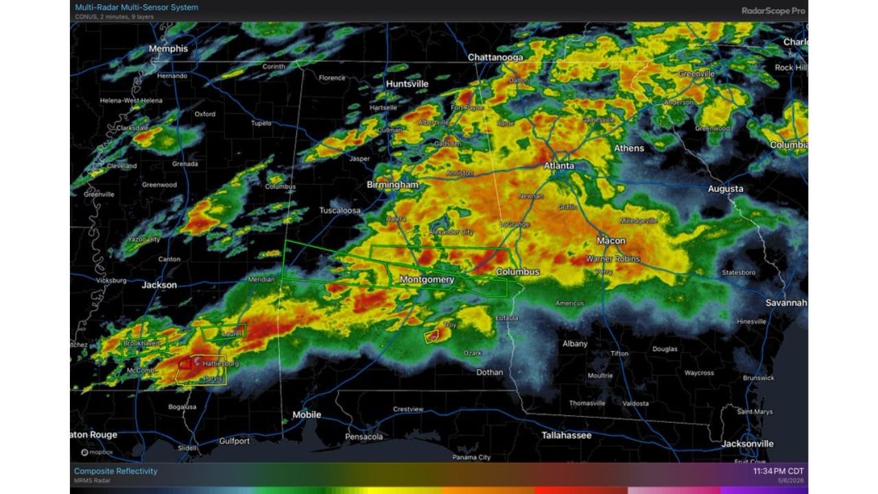
Radar Situation at 11:34 PM CDT
Composite reflectivity shows a broad and intense rain shield draped across Alabama from the Mississippi state line through Birmingham, Montgomery and into the Columbus, Georgia corridor. The heaviest cores are concentrated across central Alabama with additional intense cells near Hattiesburg and Purvis in southern Mississippi where the tornado watch threat is most active. The Birmingham through Atlanta corridor shows widespread moderate to heavy rain with no organized severe structures currently evident.
What to Watch Through 6 AM Thursday
- Do not drive through flooded roads between York, Livingston, Auburn and Opelika. Four-plus inches of rain makes road conditions dangerous and water depth unpredictable
- Tornado watch remains active until 6 AM for South Alabama and Southern Mississippi — keep alerts on through overnight
- Strong tornadoes remain possible in the Hattiesburg, Laurel, McComb and Brewton zones despite overall low severe threat
- Instability is fading which reduces but does not eliminate the tornado threat before the watch expires
- Monitor creek and stream gauges across central Alabama overnight as rainfall totals continue to accumulate
WaldronNews.com will continue tracking flash flood warnings and the tornado watch across Alabama and Mississippi and will provide updates as conditions change through early Thursday morning.