
Nebraska, South Dakota and Iowa Face Level 3 Enhanced Risk With Isolated EF2 Tornadoes and Baseball Size Hail Sunday May 17 Including Sioux Falls, Omaha and Lincoln While Kansas and Oklahoma Face Level 2 Slight Risk With Large Hail and Damaging Gusts
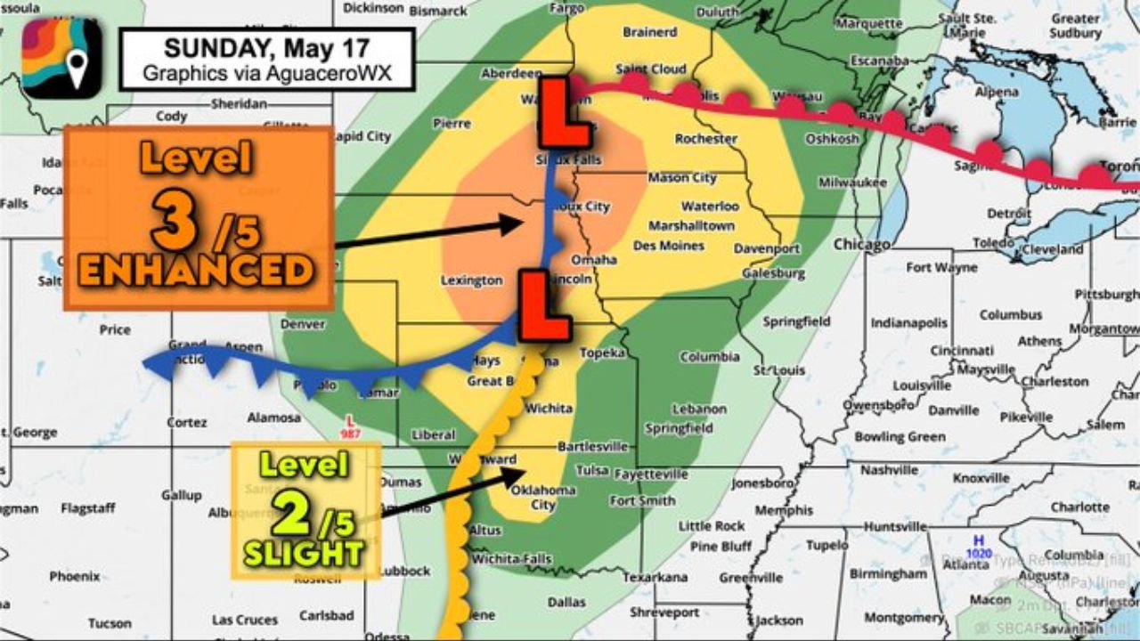
OMAHA, Nebraska – A Level 3 Enhanced severe weather risk is in place for Sunday, May 17 across Nebraska, eastern South Dakota and southwest Iowa, where several rotating supercell thunderstorms are expected to produce baseball size hail, tornadoes and isolated EF2 or stronger tornadoes. Communities from Sioux Falls south through Omaha and Lincoln face the most dangerous conditions of the day.
Two Separate Risk Zones Sunday May 17
Sunday, May 17 features two distinct severe weather threat areas that residents across the central Plains need to understand:
- The Level 3 out of 5 Enhanced risk zone covers the highest-danger corridor centered on Sioux Falls, Sioux City, Omaha and Lincoln, where several supercells are expected to fire along the dryline and cold front. This is where baseball size hail, tornadoes and isolated EF2 or stronger tornadoes are considered likely.
- The Level 2 out of 5 Slight risk zone extends south into Kansas and Oklahoma, covering Topeka, Wichita, Oklahoma City and Wichita Falls, where isolated supercells could produce large hail, damaging gusts and an isolated tornado if storms organize along the dryline.
Why Nebraska and South Dakota Face the Greatest Tornado Danger
The tornado risk Sunday is greatest in Nebraska and along the I-29 corridor north into eastern South Dakota and southwest Iowa because of the way winds are changing with height near the low pressure centers tracking through the region. These changing winds create spin in the atmosphere that rotating thunderstorms, called supercells, can harness to produce tornadoes. Several supercells are expected to develop in this zone Sunday, May 17, making multiple tornado touchdowns likely rather than just possible.
Baseball Size Hail Is a Serious Property Threat
Baseball size hail measures approximately 2.75 inches in diameter and is large enough to total vehicles, shatter windows, punch through roofs and injure anyone caught outdoors. This is the size of hail expected with the strongest supercells firing across the Level 3 Enhanced zone from Sioux Falls through Omaha and Lincoln on Sunday, May 17. Move all vehicles into a garage or under solid cover before storms develop Sunday afternoon.
Cities Inside the Level 3 Enhanced Zone
The following communities face the highest severe weather risk this Sunday, May 17:
- Sioux Falls, South Dakota sits near the northern anchor of the Level 3 Enhanced risk zone and faces a real threat of supercells with baseball size hail and tornadoes including isolated EF2 or stronger tornadoes Sunday.
- Sioux City and Des Moines, Iowa are within or near the Enhanced risk corridor and should prepare for all severe hazards through Sunday afternoon and evening.
- Omaha and Lincoln, Nebraska are squarely inside the highest-risk zone and face baseball size hail, rotating supercells and a tornado threat including isolated EF2 or stronger tornadoes on Sunday, May 17.
- Lexington and Topeka sit along the southern edge of the Enhanced zone and could see supercells push through during Sunday afternoon.
- Waterloo, Marshalltown and Davenport, Iowa fall within the broader threat area and should monitor conditions closely all day Sunday.
Cities Inside the Level 2 Slight Zone
Communities across Kansas and Oklahoma face a lower but still real severe weather risk Sunday, May 17:
- Wichita and Liberal, Kansas are within the Level 2 Slight risk zone where isolated supercells could fire along the dryline and produce large hail, damaging gusts and an isolated tornado.
- Oklahoma City, Woodward and Altus, Oklahoma fall within the Slight risk area and face the same threat of isolated supercell development Sunday.
- Wichita Falls and Dallas, Texas sit on the southern edge of the Slight risk zone and should not dismiss the possibility of an isolated severe storm developing Sunday.
What EF2 Tornadoes Can Do
An EF2 tornado packs winds of 111 to 135 mph and is capable of destroying mobile homes completely, snapping large trees, ripping roofs off well-built homes and turning loose objects into deadly projectiles. The fact that isolated EF2 or stronger tornadoes are being highlighted for the Level 3 Enhanced zone on Sunday, May 17 means residents across Nebraska, eastern South Dakota and southwest Iowa need a solid shelter plan ready before storms arrive.
What You Must Do Before Sunday Afternoon
Anyone from Sioux Falls and Des Moines south through Omaha, Lincoln and Topeka must finalize their severe weather shelter plan before Sunday morning, May 17. Know which interior room on the lowest floor of a sturdy building you will shelter in. Keep weather alerts active on your phone all day Sunday. Do not attempt to shelter in a mobile home or vehicle during a tornado warning. Get to a sturdy structure immediately.
WaldronNews.com will continue tracking this Level 3 Enhanced tornado and baseball size hail threat across Nebraska, South Dakota and Iowa and will provide updates as supercell development and tornado reports emerge throughout Sunday, May 17.