
North Carolina and South Carolina Finally See Rain Chances This Weekend But Need 10 to 20 Inches Over Months to Break Historic Drought
CHARLOTTE, North Carolina — After months of brutal drought, North Carolina and South Carolina are finally getting a glimmer of hope — a gradual shift in the weather pattern is bringing some rain chances this weekend and potentially better coverage the following week. But forecasters are urging residents to temper expectations: droughts this severe are very difficult to break, and the Carolinas need 10 to 20 inches of rainfall spread over 2 to 3 months to meaningfully eliminate what has become a historic dry stretch.
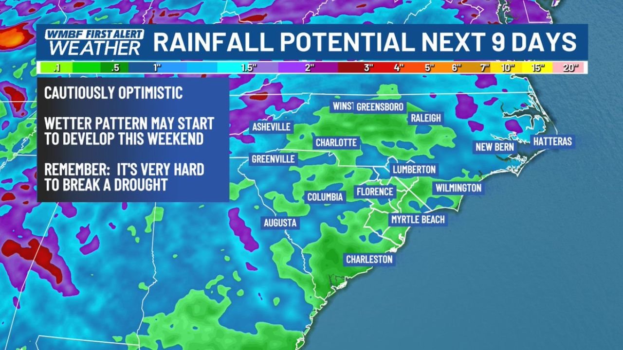
The 9-day rainfall potential map shows a cautiously optimistic signal — a wetter pattern may begin developing this weekend, with shower chances scattered across Charlotte, Raleigh, Wilmington, Asheville and surrounding communities.
Areas Watching for Drought-Breaking Rain
Every corner of both states is desperate for rainfall:
- North Carolina: Raleigh, Greensboro, Winston-Salem, Asheville, Charlotte — all deep in drought and in the rainfall potential zone for the next 9 days
- South Carolina: Columbia, Charleston, Myrtle Beach, Florence, Greenville — entire state watching this weekend’s rain chances closely
- Coastal Carolinas: Wilmington, New Bern, Hatteras — coastal communities included in the rainfall potential area
- Lumberton and Surrounding Region: Interior Carolinas seeing 1–2 inch potential in the 9-day window
The Hard Truth About Breaking This Drought
The rain chances are welcome — but the math is sobering:
- 10 to 20 inches needed spread over 2 to 3 months to eliminate the drought across most of the Carolinas
- This weekend’s rain — a shower or two possible, a start but nowhere near sufficient on its own
- Droughts become self-sustaining — dry soils absorb initial rainfall before any runoff reaches streams and reservoirs, meaning the first several inches of rain effectively disappear into the ground
- Consistent, significant rain for weeks is the only path to meaningful drought recovery — isolated events provide temporary relief but do not break the pattern
- 100% of the Southeast is in drought — the Carolinas are part of a regional crisis, not an isolated local problem
Why Charlotte and the Carolinas Face a Long Road
Charlotte, North Carolina and communities across both states have been running 15 to 20 inches below normal rainfall since October — one of the driest six-month stretches on record across the entire Southeast. That kind of deficit does not disappear after a weekend of showers.
Here is what makes drought recovery so difficult: when soils become as dry as they are right now across the Carolinas, they act like a sponge. The first inch of rain — even the first several inches — simply soaks into cracked, depleted soil without generating any meaningful runoff into creeks, rivers, or reservoirs. Water managers and farmers see little benefit until the soil moisture deficit is substantially filled.
That is why the 10 to 20 inch target spread over 2 to 3 months is the realistic benchmark. It accounts for the initial soil absorption, the ongoing evaporation losses from dry and warm spring conditions, and the sustained input needed to actually raise water levels in reservoirs and restore stream flows to normal.
This weekend’s shower chances are a positive sign that the pattern is shifting — but one weekend of rain does not break a six-month drought. The following week’s better rain chances, if they materialize, would be more meaningful. And then the week after that. Only consistent, multi-week above-normal rainfall will make a real dent.
Multi-Day Pattern
This weekend — a shower or two possible across the Carolinas as the pattern begins shifting. The following week — better rain chances developing as the wetter pattern potentially strengthens. Beyond that, the pattern trend is cautiously encouraging but far from guaranteed. Any significant drought relief will require this wetter signal to verify and then persist for weeks — not days.
The broader Southeast drought, which covers 100% of the region with 83% rated severe or worse, will require an extended period of above-normal precipitation across multiple states to meaningfully recover.
What to Watch Next
- Weekend rainfall totals across Charlotte, Raleigh, and Columbia — whether showers deliver meaningful accumulations or just brief sprinkles
- The following week’s rain potential — whether the wetter pattern strengthens or fades
- Reservoir levels across the Carolinas as any rainfall accumulates
- Whether the 9-day rainfall potential of 1.5 to 2 inches across interior North Carolina verifies
- Drought monitor updates showing whether conditions improve, hold steady, or worsen heading into May
Residents across North Carolina and South Carolina should welcome this weekend’s rain chances — but understand that the path out of this historic drought is measured in months, not days. Every inch counts, and the pattern shift is a positive step.
WaldronNews.com will continue tracking drought recovery rainfall chances across the Carolinas and provide updates as the weekend pattern develops.