
Utah Mountains Buried Under 3 to 9 Inches of Snow Thursday as Alta, Park City and Logan Face Two-Day Winter Storm
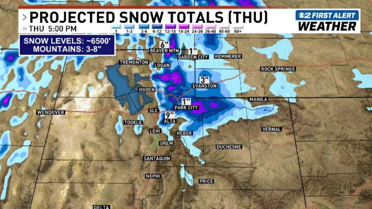
SALT LAKE CITY, Utah — A two-round winter storm is targeting northern Utah Wednesday through Thursday, with mountain snow levels dropping to 6,500 feet and projected totals reaching 3 to 8 inches across the mountains — with Alta seeing up to 9 inches and Park City picking up 1 inch of accumulation by Thursday at 5 PM.
The first round arrives Wednesday with an initial shot of mountain snow, followed by the heavier and more significant Thursday round as the main part of the storm pushes through northern Utah.
Areas Seeing the Most Snow Thursday
Projected totals by Thursday afternoon show a clear bull’s-eye over the northern Utah mountains:
- Alta: Up to 9 inches — highest total in the forecast, deep in the Wasatch Range
- Beaver Mountain: 6 inches projected by Thursday afternoon
- Logan: In the path of the heavier northern Utah snowfall
- Evanston, Wyoming: 3 inches just across the Utah border
- Park City: 1 inch at lower mountain elevations
- Garden City / Bear Lake area: 1 inch on the northeastern edge
- Salt Lake City valley: Lower elevation accumulation possible but bulk of snow stays above 6,500 feet
Primary Threats
The two-day storm brings layered impacts across northern Utah:
- 3 to 8 inches in the mountains with Alta reaching 9 inches — significant late-season accumulation for ski resorts and mountain roads
- Snow levels at 6,500 feet — keeping the heaviest snow in the mountains but bringing wintry mix potential to some higher valley communities
- Two separate rounds Wednesday and Thursday — the Thursday round carrying the bulk of accumulation as the storm’s main energy pushes through
- Travel impacts on mountain passes and canyon roads serving the Wasatch Front communities
Why This Matters for Salt Lake City and Northern Utah
Salt Lake City, Utah sits at the base of the Wasatch Range — and when snow levels drop to 6,500 feet, every canyon road connecting the valley to mountain communities and ski resorts becomes a potential travel hazard. Little Cottonwood Canyon — the access road to Alta and Snowbird — is one of the most avalanche-prone roads in the country, and significant late-season snowfall events like this one trigger closures and avalanche control work that affect thousands of commuters and visitors.
For ski resorts, 9 inches at Alta in late April is genuinely welcome — extending the season and refreshing the snowpack at a time when spring skiing conditions often deteriorate. But for anyone driving canyon roads Wednesday night into Thursday, conditions can go from wet to treacherous quickly once snow levels drop to the forecast elevation.
The two-round nature of this storm is the key detail for planning purposes. Wednesday’s first round may seem manageable, but Thursday’s heavier accumulation arrives on top of already-wet roads and partially compacted snow — creating icier and more difficult travel conditions than either round alone would produce.
Northern Utah communities including Logan, Tremonton, and Ogden should expect periods of snow at higher elevations through Thursday with conditions improving by Friday as the storm exits to the east.
Multi-Day Pattern
The storm clears northern Utah by Thursday night into Friday, with improving conditions expected for the weekend. No additional significant winter storm systems are currently indicated for Utah through the end of April, though the active spring pattern means additional rounds of mountain snow remain possible into May across the higher elevations of the Wasatch Range.
What to Watch Next
- Canyon road conditions Wednesday night as the first round of snow begins accumulating above 6,500 feet
- Thursday morning conditions on I-80 through Parley’s Canyon and US-189 through Provo Canyon
- Whether Alta’s total surpasses the 9-inch projection if the Thursday storm tracks slightly further south
- Avalanche danger ratings for Little Cottonwood and Big Cottonwood Canyons through Thursday
- Friday clearing timeline and road treatment status for mountain passes
Residents and travelers across northern Utah — especially anyone planning mountain travel Wednesday night or Thursday — should check road conditions before heading into the canyons and be prepared for rapidly changing winter driving conditions.
WaldronNews.com will continue tracking Utah’s two-day winter storm and provide updates as snowfall totals and road conditions develop.