
Northern Oklahoma Sees Spectacular High-Based Storms Friday Afternoon With Dramatic Lightning and Large Anvils as Deep Shear Drives Photogenic Supercells Near Tulsa and Enid
TULSA, Oklahoma — Northern Oklahoma is producing a handful of high-based, visually dramatic supercells Friday afternoon that are generating spectacular lightning photography opportunities even as the overall severe threat remains limited. Strong deep-layer wind shear, steep lapse rates and mostly streamwise shear vectors are driving storms that look convective and explosive rather than smooth and capped, with anvils blowing east and southeast as upper-level winds carry the storm tops downwind. Forecasters expect a couple of high-based storms across northern Oklahoma today, particularly those that avoid merging with neighboring cells.
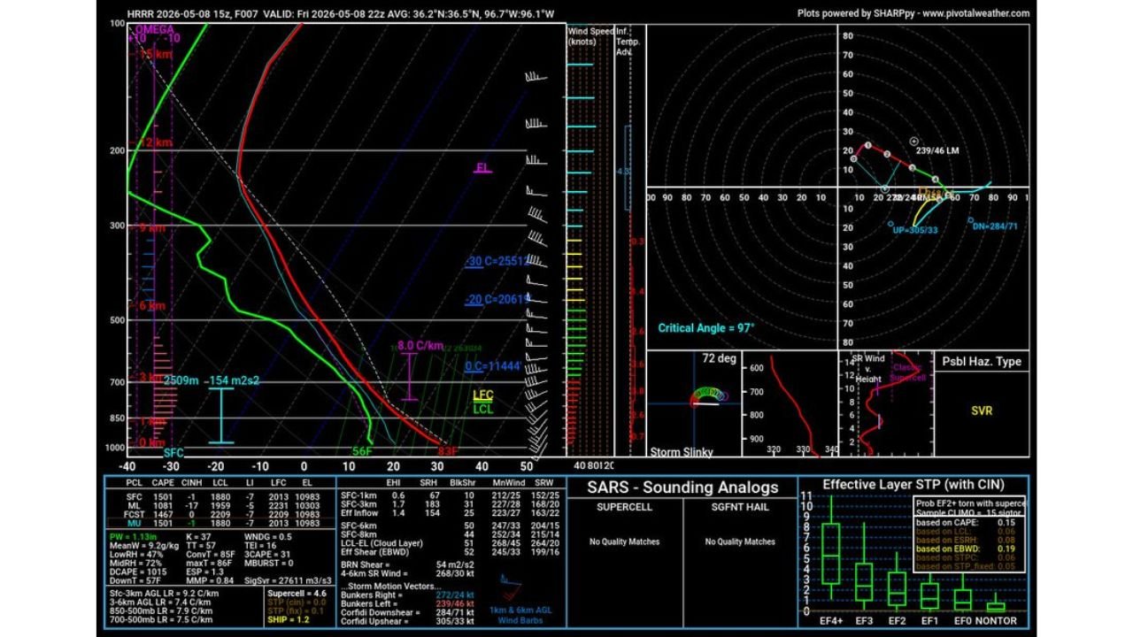
What the Atmosphere Is Producing
Forecast sounding valid 10 PM CDT Friday May 8 near 36.2 North, 96.7 West shows:
- Surface-based CAPE: 1,538 J/kg
- Mixed-layer CAPE: 10,303 J/kg — extremely high instability at the mixed layer level
- Forecast CAPE: 1,467 J/kg
- LCL: 2,509 meters — a very high cloud base, which is why these storms look high-based and photogenic rather than low and threatening
- Negative SRH: -154 m2/s2 — the negative value explains why tornado potential is essentially zero despite the impressive storm appearance
- EF Shear (EBWD): 51 knots — strong deep-layer shear driving the dramatic anvil structure
- BRN Shear: 54 m2/s2
- Supercell Composite: 4.6
- SHIP: 1.2 — large hail remains possible with the strongest cells
- Critical Angle: 97 degrees — excellent wind alignment for supercell structure
- SARS analog: SVR hazard type — severe thunderstorm rather than tornado the primary concern
- Low relative humidity: 47% — contributing to the high LCL and photogenic appearance
Why These Storms Look So Dramatic
High-based storms in low-humidity environments produce some of the most visually stunning severe weather photography possible. The combination working in northern Oklahoma today:
- High LCL at 2,509 meters means the cloud base sits very high above the ground — storms develop tall, towering structures visible from great distances
- Steep lapse rates allow updrafts to accelerate rapidly, creating the explosive cauliflower-topped appearance of convective storms
- Strong deep-layer shear tilts the storm and blows the anvil dramatically east and southeast — creating the classic anvil structure storm chasers and photographers seek
- Lack of CIN means storms fire freely and develop the raw convective look rather than the smooth, capped appearance seen when storms struggle against a stable layer
What the Severe Threat Actually Is
Despite the impressive appearance, the severe weather threat today in northern Oklahoma is limited:
- Tornado threat is essentially zero — the negative SRH value means rotation is not favoring tornado production
- Large hail remains the primary hazard with the most organized cells — SHIP of 1.2 supports hail potential
- Damaging winds possible with any storm that becomes strongly organized
- Storms avoiding mergers will be the most photogenic and potentially the most severe — merged cells tend to lose their discrete structure and produce less organized hazards
What Storm Photographers Should Know
- Northern Oklahoma between Tulsa, Enid and the Kansas border is the primary zone for the most photogenic storm structure today
- Anvils blowing east and southeast — position yourself to the south or southeast of developing storms for the best angle on the anvil and updraft structure
- Lightning frequency will be high as these convective storms generate frequent discharges — wide-angle setups capturing the full storm structure will show the most dramatic results
- Never approach a storm on foot for photography — maintain a safe distance with a clear escape route to the south or southeast away from storm motion
WaldronNews.com will continue tracking storm development across northern Oklahoma and will provide updates as storms evolve through the Friday evening hours.