
Regional Tornado Outbreak Possible Tuesday With EF3 and EF4 Tornadoes on the Table Across Wisconsin, Illinois and Iowa as Chicago, Milwaukee, Cedar Rapids and Davenport Face Violent Storm Threat
CHICAGO, Illinois — A 2:00 PM Tuesday update has dramatically escalated the severe weather threat across the Upper Midwest — with a regional tornado outbreak now possible and EF3 and EF4 violent tornadoes explicitly on the table across a focused zone covering Wisconsin, northern Illinois, and eastern Iowa as three separate atmospheric boundaries converge simultaneously over one of the most densely populated corridors in the Midwest.
This is no longer a routine severe weather situation. The intersection of a warm front, a differential heating boundary, and a leftover outflow boundary from Monday’s storms has created a convergence of multiple tornado-enhancing mechanisms over the same geographic area at the same time — with each boundary adding additional low-level helicity — atmospheric spin — that rotating supercells can absorb and use to produce violent, long-track tornadoes.
Several tornadoes are now possible today — including a few rated EF2 or EF3 strength — across a broad risk corridor, while the innermost zone covering Wisconsin, northern Illinois, and the Chicago metro area carries explicit EF3+ tornado potential.
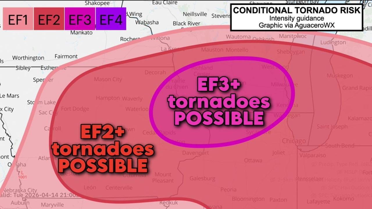
The Conditional Tornado Risk — Two Zones of Danger
The Conditional Tornado Risk graphic breaks today’s threat into two clearly defined and escalating zones:
EF2+ Tornado Zone — Broader Risk Area: The large pink zone covers a sweeping corridor from Nebraska City and Omaha in the west through Mason City, Fort Dodge, Waterloo, Cedar Rapids, and Davenport in Iowa, extending east through Galesburg, Ottawa, Peoria, Bloomington, and Paxton in Illinois and reaching into Indiana communities including Valparaiso, Rensselaer, Lafayette, and Kokomo. Every community in this pink zone faces the possibility of EF2 tornadoes — storms with winds of 111 to 135 mph capable of destroying well-constructed homes, snapping large trees, and causing catastrophic damage across wide damage paths.
EF3+ Tornado Zone — Violent Tornado Bullseye: The inner magenta/purple oval represents the most dangerous zone on today’s map — where EF3 or stronger violent tornadoes are possible. This bullseye is centered over a corridor running from Richland Center, Wisconsin through Madison, Milwaukee, Kenosha, and Chicago — encompassing one of the highest population density zones in the entire Upper Midwest. An EF3 tornado carries winds of 136 to 165 mph and can level entire neighborhoods, sweep vehicles off highways, and cause deaths in even well-constructed structures without adequate shelter. An EF4 — also shown as possible on today’s intensity guidance — carries winds of 166 to 200 mph and is catastrophically destructive.
Three Boundaries Stacking Over the Same Area — Why This Is So Dangerous
What makes Tuesday’s setup exceptionally alarming is not just the instability or the wind shear — it is the simultaneous convergence of three separate storm-triggering and tornado-enhancing boundaries over the same geographic area:
The Warm Front — The primary atmospheric boundary lifting north through the region that has been driving tornado potential all day. Supercells that latch onto the warm front can absorb the concentrated low-level helicity along the boundary and produce long-track, violent tornadoes.
The Differential Heating Boundary — A secondary boundary created by differences in surface heating between cloud-covered and sun-exposed areas. This boundary adds an additional source of low-level spin and storm-triggering lift that is separate from and additive to the warm front.
The Leftover Outflow Boundary from Monday’s Storms — The remnant exhaust boundary from Monday night’s tornado-producing storms across southern Minnesota and northern Iowa is still sitting across the region today. When a supercell crosses or runs along this boundary, it can suddenly and dramatically intensify its rotation — this mechanism has been responsible for some of the most unexpected violent tornado episodes in Midwest history.
The convergence of all three boundaries in the same zone means that any supercell operating in the Wisconsin-Illinois-Iowa EF3+ corridor today has three simultaneous sources of additional low-level helicity to feed on — making the tornado-producing potential in this corridor genuinely extraordinary.
Communities in the EF3+ Violent Tornado Zone — Act Now
The inner bullseye zone where EF3+ violent tornadoes are possible covers:
- Wisconsin: Richland Center, Madison, Milwaukee, Kenosha, Waukesha, Sheboygan, and the broader southern Wisconsin corridor
- Illinois — Northern: Chicago, Joliet, Waukegan, and the broader Chicago metro area sit directly inside the EF3+ possible zone — one of the largest urban areas in the country facing violent tornado potential today
- Illinois — Northeast: Valparaiso and northern Indiana border communities
Communities in the EF2+ Zone — Serious Threat
- Iowa: Mason City, Fort Dodge, Waterloo, Cedar Rapids, Iowa City, Davenport, and the broader eastern Iowa corridor
- Illinois — Central: Galesburg, Ottawa, Peoria, Bloomington, Paxton, and central Illinois communities
- Indiana: Valparaiso, Rensselaer, Lafayette, Kokomo, and the northwestern Indiana corridor
- Nebraska/Iowa border: Nebraska City, Omaha area communities on the western edge of the risk zone
- Minnesota — Southern fringe: Mankato, Worthington, Fairmont, Sibley, and Estherville communities on the northern edge of the EF2+ zone
What EF3 and EF4 Tornadoes Mean for Urban Areas Like Chicago and Milwaukee
The prospect of EF3 or EF4 tornadoes tracking through or near major urban centers like Chicago and Milwaukee represents a severe weather scenario that demands the most urgent possible response from every resident in the EF3+ zone. In urban environments, violent tornadoes carry additional dangers beyond their raw wind speed:
High-rise buildings provide no tornado protection and should be evacuated to lower interior floors immediately when warnings are issued. Flying debris in dense urban areas includes glass, metal, vehicles, and structural fragments that become lethal projectiles at EF3+ wind speeds. Underground parking garages and subway stations are among the safest shelter options in dense urban areas when interior rooms in sturdy buildings are not available.
For Chicago metro residents specifically — the EF3+ bullseye covering this area today is an extremely rare and serious designation that demands immediate preparation. The Chicago area is not frequently targeted by violent tornado potential, making today’s setup historically unusual and critically important for residents to take seriously.
What Every Resident From Iowa to Indiana Must Do Right Now
- Chicago, Milwaukee, and Madison residents — you are inside the EF3+ violent tornado zone. Identify your shelter location immediately — lowest floor interior room away from all windows — and be ready to move there the moment a tornado warning is issued for your county
- Cedar Rapids, Davenport, Peoria, and Bloomington residents — you are in the EF2+ zone. These tornadoes are capable of destroying well-constructed homes — shelter in the lowest interior room, not just an interior room
- Do not seek shelter in vehicles, mobile homes, or open structures under any circumstances if a tornado warning is issued today — EF2 through EF4 tornadoes will destroy these structures completely
- Have multiple warning systems active simultaneously — phone alerts set to override Do Not Disturb, weather radio, and a weather app with push alerts all running at the same time
- The outflow boundary from Monday’s storms means tornado development today could be sudden and rapid — warnings may come with very short lead times. Do not wait for the tornado to be visible before moving to shelter
- Chicago metro commuters still on the road should identify sturdy buildings along their route where they can shelter immediately if a warning is issued — do not attempt to drive away from tornado warnings in urban traffic
Today’s regional tornado outbreak threat across Wisconsin, Illinois, and Iowa is one of the most serious severe weather situations the Upper Midwest has faced this spring. The EF3+ zone covering Chicago and Milwaukee demands immediate and urgent action from every resident in those communities.
WaldronNews.com will continue providing live updates on today’s tornado outbreak across Wisconsin, Illinois, Iowa, and Indiana and will provide immediate reports as tornado warnings, confirmed tornadoes, and storm damage information becomes available.