
Tornado Warnings Active Near Wichita Falls and Ada at 5 PM as Two Separate Supercells Show Warnings on Radar Right Now
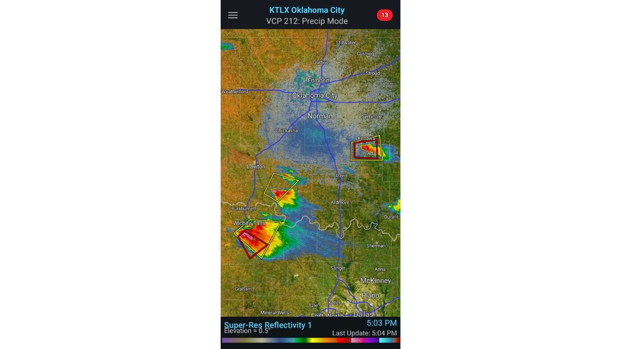
OKLAHOMA CITY, Oklahoma — Two separate tornado-warned storms are active on radar at 5:03 PM Saturday afternoon, and the situation is developing rapidly across south-central Oklahoma and north Texas. The KTLX Oklahoma City radar shows active severe weather warnings overlapping two distinct storm clusters — one near Wichita Falls, Texas and one near Ada and Konawa, Oklahoma — with tornado warning boxes already issued for both areas.
This is a live, ongoing severe weather situation. If you are in or near Wichita Falls, Lawton, Ada, or Konawa, take shelter immediately.
What the Radar Is Showing Right Now
The 5:03 PM radar scan from KTLX shows two separate storm complexes with active warning polygons drawn around them.
Near Wichita Falls, Texas and southwest Oklahoma near Lawton, two overlapping warning boxes are visible — a yellow Severe Thunderstorm Warning box and a red Tornado Warning box — surrounding a storm core showing the deep red and orange reflectivity values that indicate an intense, mature thunderstorm. This storm has organized rapidly and is now tornado-warned.
Near Ada and Konawa in east-central Oklahoma, a second set of warning polygons shows both a Severe Thunderstorm Warning and a Tornado Warning active simultaneously. This storm developed through the updraft merger process described in the forecast discussion — several updrafts in close proximity consolidated rapidly into a mature supercell that is now producing both a tornado threat and very large hail.
What Forecasters Are Observing in Real Time
The live storm update reveals two unexpected developments that are shaping how this afternoon’s event is unfolding differently than anticipated.
The storm near the outflow boundary is struggling. The lone updraft that was expected to anchor itself to the boundary and help trigger additional storm development has instead been drifting eastward, threatening to overrun the boundary completely. If it does, the storm loses its surface-based connection, weakens, and either dissipates or needs additional updraft mergers to survive. Despite its bare-bones structure right now, a tornado from this storm remains possible given the atmospheric environment surrounding it.
The Ada-Konawa storm is the more immediately impressive one. Multiple updrafts merged rapidly and the resulting supercell has grown to a size that forecasters describe as capable of sustaining several very large hailstones simultaneously. The core of this storm is substantial. While the tornado threat is present, the very large hail threat from this storm is the concurrent concern — a storm this size can produce baseball to softball-sized hail across Ada and surrounding communities at the same time a tornado is possible on its southern flank.
Ada and Konawa Are Under Direct Threat
Ada, Oklahoma with a population of roughly 17,000 sits directly under the active Tornado Warning polygon on the 5 PM radar. Konawa is on the immediate eastern edge of the warning area. Anyone in these communities who has not already moved to interior shelter needs to do so immediately.
The storm producing the warning near Ada developed through rapid updraft consolidation, which means it went from scattered cells to a mature warned supercell quickly. The hail core of this storm could be moving through the area even as the tornado threat exists on the southern side — meaning simultaneous threats of both giant hail and tornado impact are possible for the same communities within minutes of each other.
Wichita Falls Has an Active Warning Right Now
Wichita Falls, Texas is inside an active Tornado Warning at 5:03 PM. The storm producing this warning shows intense reflectivity values on the western side of the warning polygon. Lawton, Oklahoma is north of the warning area but close enough to the activity that residents there should be monitoring the situation closely.
The storm near Wichita Falls is the one forecasters are watching most carefully regarding the outflow boundary interaction. If the updraft stabilizes on the boundary rather than drifting east, additional intensification is possible. If it overruns the boundary, the storm structure degrades. That evolution is unfolding in real time right now.
If You Are in These Areas — Act Now
Tornado warnings are not the time to watch from a window or check social media for updates. They are the time to be in your shelter. Interior room, lowest floor, away from windows, with as many walls between you and the outside as possible.
Ada and Konawa residents: move to shelter now if you have not already done so.
Wichita Falls residents: you are inside an active Tornado Warning. Take shelter immediately.
Oklahoma City and Norman are currently seeing widespread rain and stratiform precipitation on radar but are not under tornado warnings at this time. Monitor radar and keep alerts active as the storms to the south evolve.
WaldronNews.com is tracking this active severe weather situation and will provide updates as the tornado warnings evolve and new developments occur.