
Washington DC, Maryland and Virginia Face Cloudy Showers Monday May 11 With Highs Only in the 60s Before Drier Conditions Return Tuesday
WASHINGTON, DC — A few lingering showers will continue across the Washington DC, Maryland and Virginia region tonight as storms wrap up, with cool overnight lows dropping to the upper 40s to mid-50s by dawn Monday, May 11.
Monday brings cloudy and showery conditions with highs only reaching the 60s, before a drier and slowly warmer pattern takes hold beginning Tuesday.
Tonight Into Monday Morning
Showers will linger tonight as any remaining storm activity winds down. Overnight lows will settle in the upper 40s to mid-50s across the region by dawn.
Residents should expect wet roads and reduced visibility during the overnight hours heading into Monday morning, May 11.
Monday Daytime Conditions
Monday stays cloudy and showery with highs only in the 60s across the DC, Maryland and Virginia region:
- The cloudiest and wettest conditions Monday will be south and east of the Beltway, where some spots could stay stuck in the 50s all day.
- Areas north and west of the Beltway will see similar cloudy and showery conditions but have a better chance of clearing by mid-to-late afternoon.
- Most of the region is expected to clear out during the mid-to-late afternoon hours as the system pushes through.
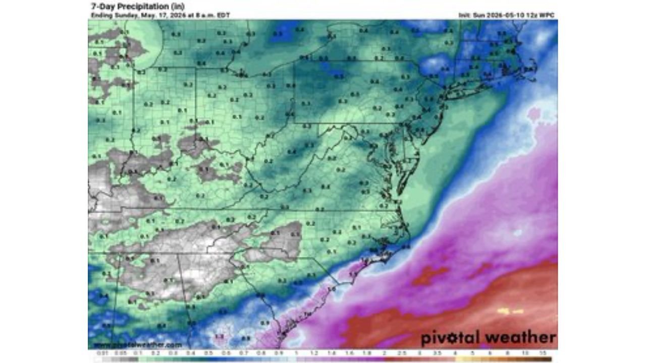
7-Day Rainfall Totals Through May 17
The 7-day precipitation map valid through Sunday, May 17 shows modest rainfall totals across the region:
- Most of Maryland and Virginia are tracking between 0.1 and 0.9 inches of total rainfall through May 17.
- Portions of the mid-Atlantic coastline are seeing higher totals on the map, while interior areas remain on the lower end of accumulation.
- Rainfall totals across the broader DC metro area fall within the lighter green range, reflecting limited rain in the week ahead once today’s system clears.
Tuesday Onward: Drier and Warmer
Conditions improve significantly starting Tuesday, May 12. A drier and slowly warming trend takes hold through the remainder of the week.
Gardeners across DC, Maryland and Virginia should not expect much rainfall in the week ahead once Monday’s system exits the region.
What to Expect Today
Residents heading out Monday, May 11 should plan for the following:
- Carry an umbrella throughout the morning and early afternoon, especially if you are south or east of the Beltway where the heaviest clouds and showers will linger longest.
- Highs will only reach the 60s at best, so a light jacket is recommended for the entire day.
- Roads should improve by mid-to-late afternoon as skies begin to clear across most of the region.
WaldronNews.com will continue tracking shower activity and the drying trend across Washington DC, Maryland and Virginia and will provide updates as clearing timing and temperatures through Tuesday, May 12 develop.