
966mb Nor’easter Hammers Rhode Island and Eastern Massachusetts With 74 MPH Gusts, 315,000+ Power Outages Reported
SOUTHERN NEW ENGLAND — A powerful 966mb nor’easter continues to lash Rhode Island and eastern Massachusetts late this morning, delivering hurricane-force wind gusts, relentless heavy snow bands, and widespread power outages across the region.
As of the 10:35 a.m. update, the storm center is tracking just outside the benchmark position offshore, maintaining an intense pressure reading of 966 millibars — a sign of a deeply consolidated and still-dangerous coastal system.
Hurricane-Force Gusts Along the Coast
Winds remain the most destructive element of this storm, particularly along exposed coastal communities.
Key wind reports include:
- Buzzards Bay buoy: Sustained 61 mph, gusts to 74 mph
- Duxbury, Massachusetts: Sustained 60 mph, gusts to 73 mph
- Montauk (unconfirmed): Gust reported to 84 mph
- Block Island: Gusts over 70 mph earlier
These wind speeds are capable of causing structural damage, downed trees, and widespread power interruptions.
Blowing and drifting snow continue to reduce visibility, even in areas where snowfall intensity has temporarily eased.
More Than 315,000 Without Power
Utility outages have surged across southern New England.
- Over 315,000 customers without power across SNE
- Approximately 258,000 outages in Massachusetts, heavily concentrated in eastern MA
- Around 40,000 outages in Rhode Island
- Connecticut comparatively spared, with about 14,000 outages
Eastern Massachusetts has taken the brunt of the wind damage, while Connecticut avoided the worst gusts due to the storm’s slightly offshore track.
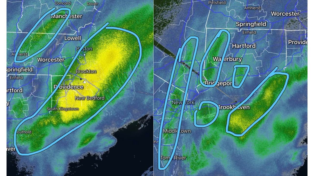
Heavy Snow Bands Still Pivoting
Snowfall distribution remains highly dependent on where intense deformation bands are sitting.
Rhode Island and eastern Massachusetts continue to be pummeled by extremely heavy snowfall, with radar showing persistent banding over:
- Providence
- Brockton
- New Bedford
- South Kingstown
- Coastal Massachusetts
Mystic and Stonington, Connecticut are on the edge of the heavy band, while additional heavier bands are evident near New Haven and stretching across western Connecticut.
Long Island and New York City are also still dealing with heavier snow bands, though lighter snow is falling between these corridors.
Forecasters warn that underachievers and overachievers will emerge based on how long communities remain under these intense bands.
Several More Inches Possible
Although the storm is gradually beginning to diminish through the day, several additional inches of snow remain possible in areas currently under the heaviest bands.
The combination of heavy snowfall and powerful winds is sustaining blizzard-like conditions in exposed coastal and elevated locations.
Gradual Improvement Expected Later Today
Conditions are expected to slowly improve as the system pulls farther northeast. However, wind gusts and blowing snow will likely continue to cause issues for several more hours.
Travel remains dangerous in many areas due to drifting snow, fallen trees, and power lines.
Bottom Line
This 966mb nor’easter has proven to be one of the most intense winter systems of the season for southern New England, with hurricane-force wind gusts, over 315,000 power outages, and ongoing heavy snow bands targeting Rhode Island and eastern Massachusetts.
Residents are urged to remain indoors, avoid unnecessary travel, and continue monitoring official updates as recovery efforts begin.
WaldronNews.com will continue providing updates as conditions evolve.