
New York and Southern New England Brace for Significant Snowstorm; Long Island Could See 6–10 Inches as Fluffy, Fast-Accumulating Snow Moves In
NEW YORK — A strengthening coastal storm is expected to deliver significant snowfall across New York, Long Island, Connecticut, Rhode Island, and parts of southern New England from late Sunday into Tuesday morning.
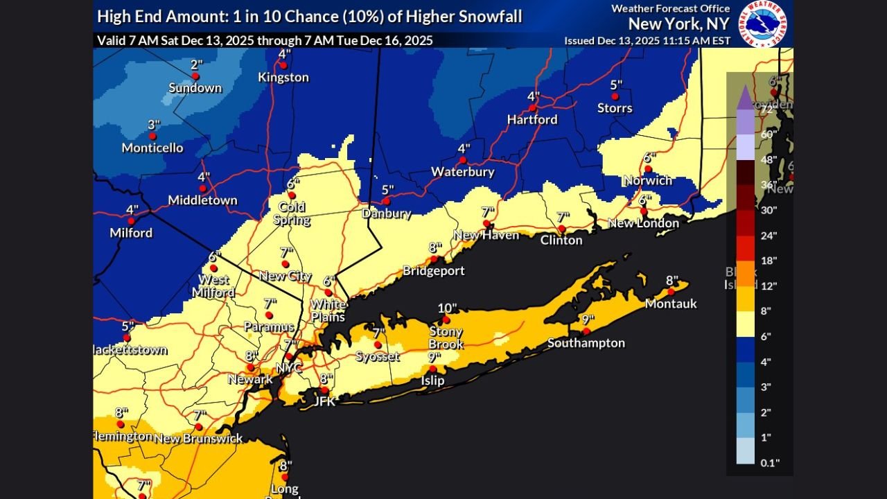
Forecast models and National Weather Service high-end probability maps show a concentrated band of heavy snow targeting Long Island and coastal southern New England, with isolated totals exceeding 6 inches — and possibly nearing 10 inches in some areas.
Long Island Positioned for Highest Totals: 6″ to 10″ Possible
Snowfall maps from NOAA and Pivotal Weather consistently highlight a bright band of higher totals stretching from central to eastern Long Island, including:
- Stony Brook: 10″
- Islip: 9″
- Montauk: 8″
- Southampton: 9″
- Brentwood: 5.3″
Meteorologists note that a 10:1 snow ratio early in the storm will shift toward a 15:1 ratio, meaning smaller, fluffier snowflakes that accumulate faster, especially after sundown.
Given this setup, forecasters say they “would not be shocked to see an isolated area of 6 inches or more somewhere from eastern Long Island toward Martha’s Vineyard and Cape Cod.”
New York City Metro to See 4″ to 6″+
Snow totals around the greater NYC region reflect a moderate-impact winter storm:
- New York City: 4.3″
- Yonkers: 3.7″
- White Plains: 6″
- Paramus, NJ: 7″
- New Brunswick, NJ: 8″
While NYC sits slightly outside the heaviest band, the high-end probability map shows a 10% chance that totals could locally exceed 6 inches if heavier bands drift west.
Connecticut, Rhode Island, and Southern Massachusetts in 3″ to 6″ Zone
Across interior southern New England, steady snow is expected, with Pivotal’s accumulation map showing:
- Hartford: 2.4″
- Waterbury: 2.9″
- Norwich: 4.0″
- Providence: 3.0″
- Barnstable (Cape Cod): 6.7″
Cape Cod’s eastern edge aligns with the same heavier coastal band impacting Long Island, increasing the possibility of higher localized totals.
Why This Storm Will Accumulate Quickly
Meteorologists emphasize two key snowfall factors:
- Snow-to-liquid ratio increases from 10:1 to 15:1 tonight, creating lighter, powdery snow that sticks more efficiently.
- Cold air is already in place, meaning accumulation begins early and continues steadily.
This combination means even modest precipitation rates can create rapid road coverage.
Timing: Snow Begins Tonight and Peaks Overnight
Based on model guidance:
- Snow begins late Sunday across NY, CT, and RI
- Heaviest snow falls overnight into early Monday
- Steady snowfall continues into Tuesday morning for some coastal areas
Commuters across New York City, Long Island, Connecticut, and Rhode Island should prepare for slippery travel, particularly during the Monday morning rush.
Travel Impacts Across the Region
Drivers should expect:
- Reduced visibility in coastal heavy bands
- Quick road coverage due to fluffy snow
- Hazardous conditions on highways including I-95, the LIE, and the Merritt Parkway
- Potential flight delays at JFK, LaGuardia, and Newark
The NWS high-end probability map highlights that even a slight shift in storm track could increase snow totals dramatically along the I-95 corridor.
A Significant Early-Season Snow Event
For many communities across New York and southern New England, this storm will mark the first substantial snowfall of the 2025–2026 winter season, arriving with colder air and ideal accumulation conditions.
WaldronNews.com will continue monitoring updated snowfall forecasts, NWS alerts, and storm timing as the system intensifies along the East Coast.