
Pennsylvania Records One of Its Coldest Starts to December in More Than a Decade as Eastern U.S. Plunges Well Below Normal
PENNSYLVANIA — The first 10 days of December have delivered one of the coldest openings to the month Pennsylvania has experienced since at least 2010, according to newly analyzed temperature-anomaly maps comparing early-December conditions to the 1991–2020 climate average. Much of the eastern United States has endured an unusually sharp and widespread cold spell, with Pennsylvania among the states experiencing the most persistent below-normal temperatures.
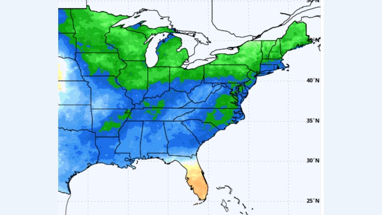
Maps Show Widespread Cold Across the East, With Pennsylvania Deep in the Blue Zone
Regional temperature-anomaly graphics reveal a broad swath of below-average temperatures stretching from the Midwest through the Mid-Atlantic and into New England.
Pennsylvania appears consistently shaded in deeper blue tones — indicating temperatures 5 to 10 degrees below average during the December 1–10 window.
Only a few areas in the East escaped this cold pattern, and none of them were in the Mid-Atlantic. Florida stands out as the lone warm anomaly, while the Great Lakes, Northeast, and Mid-Atlantic were dominated by repeated intrusions of cold air.
Coldest Opening to December Since 2010 for Eastern Markets
Meteorologists note that this year’s early-December chill is the coldest opening to the month in major eastern markets since 2010, underscoring just how unusual the pattern has been.
The graphics show:
- A large cold pool covering the Ohio Valley, Mid-Atlantic, and Northeast
- Reinforcing shots of Arctic air spilling into the region
- Persistent cold anomalies across Pennsylvania, New York, New Jersey, Ohio, Maryland, and Virginia
This aligns with broader national climate data indicating that more than 200 million Americans have experienced well-below-normal temperatures to start December.
Pennsylvania’s Temperature Pattern: Consistently Below Normal
Pennsylvania’s early-December chill fits the larger regional trend:
- Widespread readings 5–10°F below average
- Cold anomalies stretching from western Pennsylvania into Philadelphia
- No significant warm periods interrupting the pattern
This has contributed to increased heating demand and earlier-than-usual winter impacts across the Commonwealth.
Contrast With Warmer Regions in the West and Deep South
While the East froze, much of the western United States showed warmer-than-average conditions, particularly:
- Oregon
- Washington
- Idaho
- Parts of Nevada and California
Florida also remained warmer than normal, standing out among otherwise cold eastern states.
The stark temperature split between the East and West highlights the strong dip in the jet stream that has been steering Arctic air repeatedly into the eastern half of the country.
More Cold Ahead? Forecasters Watching Mid-Month Patterns
Meteorologists say the cold pattern may ease slightly deeper into December, though another round of below-normal temperatures cannot be ruled out.
Key factors being monitored include:
- Jet-stream positioning
- Potential snowpack expansion in the Northeast and Great Lakes
- Additional Arctic air masses forming over Canada
If the pattern reloads, Pennsylvania could see more early-winter cold before Christmas.
A December Start Pennsylvanians Will Remember
The opening days of December 2025 have delivered:
- A top-tier cold outbreak for the region
- The coldest early-December period in major eastern markets since 2010
- Persistent below-average temperatures for Pennsylvania
With winter only just beginning, the Commonwealth may have more cold spells ahead — but the first 10 days of the month have already set a memorable tone.
WaldronNews.com will continue monitoring regional climate trends and updates as December unfolds.