
Maryland and the Washington, D.C. Region Brace for Overnight Snowfall as Updated Forecast Raises Totals to 2–6 Inches Across Central Maryland
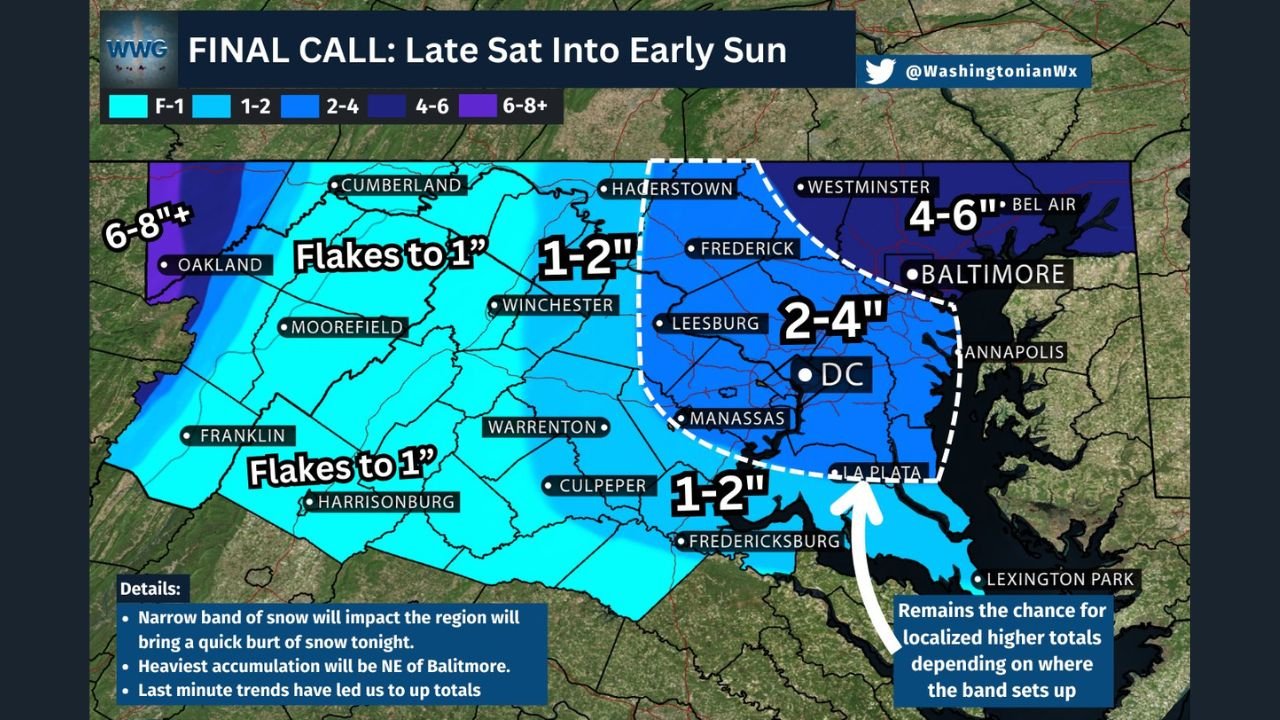
MARYLAND — A fast-moving winter system is expected to bring accumulating snow overnight across Maryland and the Washington, D.C. metro region, with last-minute forecast updates now showing higher totals than originally predicted. New model trends have expanded the 1–2 inch zone southwestward while increasing snowfall to 2–4 inches across D.C., Montgomery County, Howard County, Frederick County, and northern Virginia suburbs.
Forecasters have also added a 4–6 inch band across Baltimore and northeastern Maryland, where the heaviest corridor of snow is expected to develop.
Latest Forecast Trends Show Expanding Snow Zones
Meteorologists say the storm will produce a narrow but intense band of snow, capable of quickly coating roads and reducing visibility.
Key forecast adjustments include:
- D.C. metro region upgraded to 2–4 inches
- 1–2 inch zone pushed farther southwest, covering Fredericksburg, Warrenton, and Culpeper
- 4–6 inches added for Baltimore, Bel Air, and northeastern Maryland
- Localized higher totals possible within the hatched zone from Frederick to Baltimore depending on band placement
Forecasters emphasize that the storm’s setup is sensitive, and “where the primary snow band forms” will determine which communities experience the highest accumulation.
Heaviest Snow Expected Northeast of Baltimore
Model consensus shows the strongest lift and coldest temperatures aligning northeast of Baltimore, supporting:
- 4–6 inches from Baltimore County into Harford County
- Potential for isolated 6-inch+ spikes
- Rapid accumulation due to colder surface temperatures after sunset
Areas west and southwest of Baltimore—including Montgomery, Prince George’s, Fairfax, and Loudoun counties—are likely to receive 2–4 inches, enough to cause slippery roads overnight and early Sunday.
Regional Breakdown of Expected Snowfall
Maryland
- Baltimore / Bel Air / Westminster: 4–6 inches
- Frederick / Rockville / Silver Spring: 2–4 inches
- La Plata / Annapolis: 1–2 inches
Washington, D.C.
- District and immediate suburbs: 2–4 inches
Northern Virginia
- Leesburg / Manassas: 2–4 inches
- Fredericksburg / Culpeper: 1–2 inches
Western Maryland (Allegany / Garrett County)
- 6–8 inches+ near Oakland and higher elevations
This aligns with earlier model runs suggesting a secondary enhancement zone in the western mountains.
Travel Impacts Expected Overnight and Early Sunday
Snowfall will begin late Saturday and peak during the pre-dawn hours of Sunday, creating rapid impacts:
- Snow-covered roads likely before sunrise
- Reduced visibility during heavier bursts
- Hazardous travel on I-95, I-70, I-270, and the Capital Beltway
- Potential for school or transportation delays Monday if refreezing occurs
Transportation officials urge drivers to avoid unnecessary travel overnight to allow road crews to work safely.
Localized Higher Totals Still Possible
A dashed hatched area on the final forecast map indicates locations where totals may rise above official ranges if the main snow band pivots overhead.
These communities include:
- Frederick County
- Northern Montgomery County
- Baltimore’s northwest suburbs
Meteorologists warn that slight shifts of just 20–30 miles could significantly change final totals.
A Quick but Impactful Early-Season Winter Event
Despite being a relatively small system, tonight’s storm marks one of the first measurable snowfalls of the season for central Maryland and the D.C. region. With updated totals now higher, conditions may deteriorate quickly once snow begins.
More updates, radar tracking, and refined totals will be available through the night at WaldronNews.com.