
Maryland and Pennsylvania Expect Intense Overnight Snowburst as Radar Shows Heavy Bands Strengthening and Models Suggest Possible Thundersnow
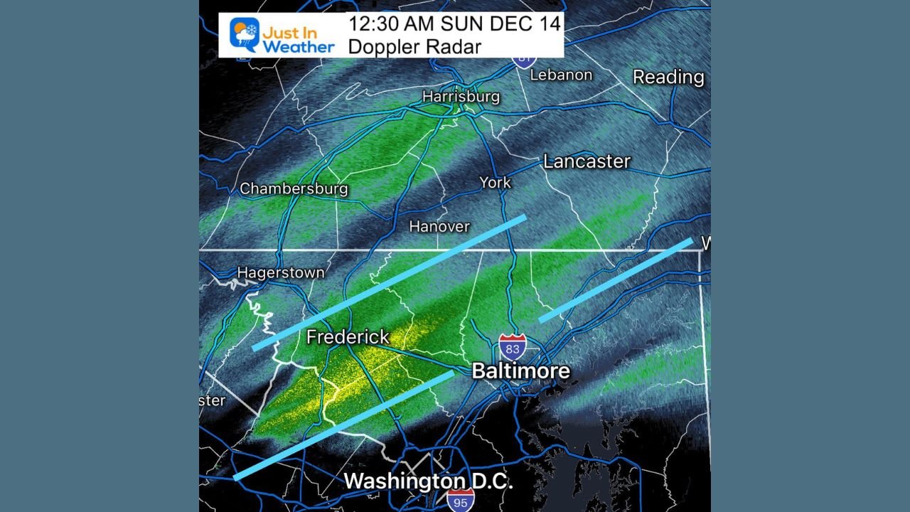
MARYLAND — A rapidly developing burst of heavy precipitation is moving across Central Maryland and southern Pennsylvania tonight, with Doppler radar already showing strengthening snow bands from Frederick to Baltimore and along the I-95 corridor. Forecasters warn that the heaviest snowfall has not yet arrived, and conditions are expected to deteriorate quickly over the next few hours.
Meteorologists note that the initial surge of precipitation has tracked slightly farther south than earlier projections, but expansion across the region is anticipated as the jet-max intensifies overhead. Anyone awake and watching conditions closely should expect snowfall rates to increase steadily as the night progresses.
Heavy Snow Bands Expected to Strengthen Overnight
Radar imagery from 12:30 AM shows a pronounced zone of moderate to heavy precipitation stretching from Washington, D.C. through Frederick and into Baltimore. These bands are expected to broaden as ascent increases.
Forecast models agree that the strongest snowfall rates will develop between 2 AM and 5 AM, particularly across:
- Central Maryland
- Southern Pennsylvania
- Areas along and just north of I-95
A corridor of enhanced lift may support brief but intense snowbursts, rapidly reducing visibility and coating roadways.
Thundersnow Possible as HRRR Model Indicates Lightning Potential
One of the most significant developments tonight comes from the HRRR model, which highlights lightning activity embedded within the snow band. This raises the possibility of thundersnow, a rare phenomenon where snowfall occurs simultaneously with thunder and lightning.
The highlighted region of lightning density stretches from western Maryland through Baltimore and into southeastern Pennsylvania. If this verifies, localized snowfall rates could briefly spike due to the stronger convection.
Snowburst Expected to Sweep Through Maryland and Southern Pennsylvania Before Dawn
High-resolution NAM model projections show an organized snowburst moving from west to east between 3 AM and sunrise, impacting:
- Baltimore
- York
- Harrisburg
- Philadelphia suburbs
- Washington, D.C. (lighter amounts expected south of the city)
The most persistent bands appear to be setting up north of Baltimore, though the entire I-95 region from D.C. to Philadelphia may experience at least a brief period of heavy snow.
Travel Hazards Increasing Quickly
Even with modest accumulation totals, the timing and intensity of the snowbands will lead to:
- Sudden reductions in visibility
- Rapid coating on untreated roads
- Slick overpasses and secondary routes
- Potential delays for early-morning travel
Forecasters emphasize that the slow eastward progression of the system was expected, and heavier bursts will arrive toward the latter half of the overnight period.
Looking Ahead
The snowburst is forecast to move east of the region shortly after daybreak, leaving behind slippery roads and patchy freezing conditions. While widespread deep accumulation is not expected, the combination of intense snowfall rates and possible thundersnow could create hazardous conditions for several hours.
Residents are urged to monitor radar trends closely and use caution if traveling before dawn.
Stay with WaldronNews.com for continuous updates as this overnight snow event evolves.