
Maryland, Pennsylvania, Virginia, and West Virginia Facing Intensifying Snow Bands Tonight as Radar Shows Expanding Burst of Heavy Precipitation
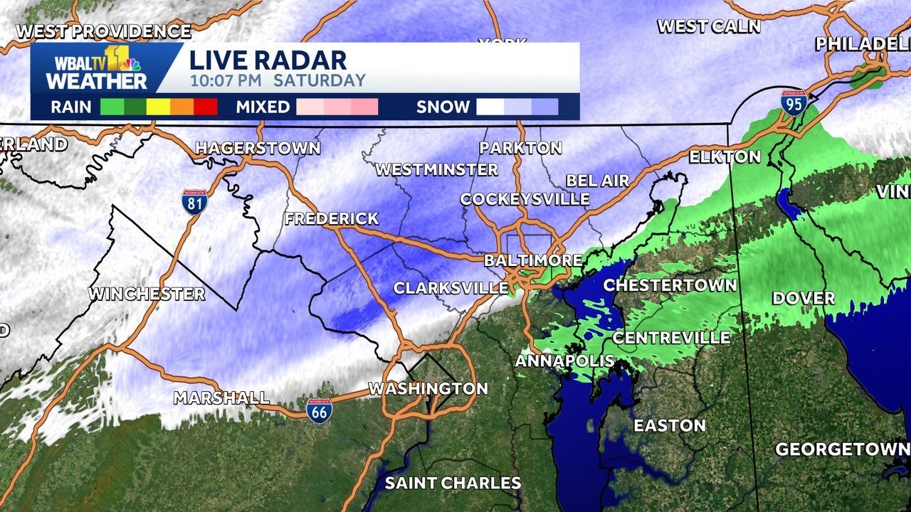
MARYLAND, PENNSYLVANIA, VIRGINIA, AND WEST VIRGINIA — A fast-developing winter system is producing a growing shield of snow across the Mid-Atlantic tonight, with expanding heavy bands now stretching from central Maryland into southern Pennsylvania, northern Virginia, and the eastern panhandle of West Virginia. Doppler radar at 10 PM shows widespread light to moderate snow, with temperatures holding between 32–37 degrees, allowing accumulation to continue on colder surfaces.
Forecasters emphasize that this is a banding-type storm, meaning snowfall intensities will vary significantly over short distances. Some locations are already overperforming early expectations, while others may briefly underperform before heavier precipitation arrives later tonight.
Heavy Snow Bands Strengthening Across the Region
Radar imagery shows a well-defined corridor of precipitation developing from Frederick and Baltimore, MD, southwest into Virginia, and northwest through Hagerstown and Martinsburg, WV, before extending into York and Harrisburg, PA.
Meteorologists note that the expansion of snow is linked to a developing jet-streak, which is helping to intensify precipitation rates across the Mid-Atlantic. As these dynamics strengthen, forecasters expect heavier bursts of snow to continue migrating east through midnight and into the early morning hours.
- Maryland: Steadiest snow developing from Frederick to Baltimore and the I-95 corridor
- Pennsylvania: Snow band strengthening into York, Lancaster, and Harrisburg
- Virginia: Winchester to Leesburg seeing steady snowfall with colder air supporting accumulation
- West Virginia: Panhandle communities seeing light-to-moderate snow with pockets of heavier returns
Snowfall totals remain on track for a general 1–4 inches, though narrow heavier bursts could push isolated areas slightly higher.
Potential for Thundersnow as Jet Dynamics Intensify
High-resolution HRRR model guidance continues to highlight a corridor of elevated lightning density from central Maryland northeast into Pennsylvania. This indicates the possibility of thundersnow, a rare but intense phenomenon where lightning occurs during heavy snow.
If thundersnow develops, snowfall rates could briefly spike, increasing accumulation in a short period.
The most favorable areas for thundersnow appear to be:
- Central Maryland, including Baltimore and the I-95 corridor
- Southern Pennsylvania, especially York and Lancaster counties
- Northern Virginia near the Maryland border
- Eastern panhandle of West Virginia
Snow Burst Expected After Midnight
Latest mesoscale model projections show a more concentrated snow burst forming between 12 AM and 3 AM, centered over:
- Baltimore Metro
- York and Lancaster, PA
- Hagerstown and Frederick, MD
- Winchester, VA
- Martinsburg, WV
This band could lead to rapid accumulation, reduced visibility, and slick roads—especially untreated secondary routes.
While some locations may continue to fluctuate between lighter and heavier snow, this variability is normal for banded winter systems.
Travel Conditions Likely to Become Hazardous Overnight
With road temperatures cooling and snowfall intensities increasing, hazardous travel conditions are expected to expand across the region. The deepest concerns are for:
- I-70
- I-83
- I-81
- I-95
Motorists are urged to use caution, reduce speed, and avoid unnecessary travel during the overnight peak.
What to Expect Through Early Sunday Morning
- General snowfall totals: 1–4 inches across MD, PA, VA, WV
- Localized higher amounts possible beneath persistent bands
- Thundersnow cannot be ruled out
- Travel impacts expected to worsen after midnight
- Snow tapers Sunday morning, with colder air settling behind the system
Stay With WaldronNews.com for Overnight Weather Alerts
WaldronNews.com will continue to monitor radar trends, snow band evolution, and any confirmed reports of thundersnow or rapidly changing road conditions. Stay with us for updated totals and new advisories as the storm progresses.