
Texas, Nebraska, Missouri, and Illinois Could See 30–40° Above-Normal Temperatures as “Blowtorch” Christmas Pattern Emerges
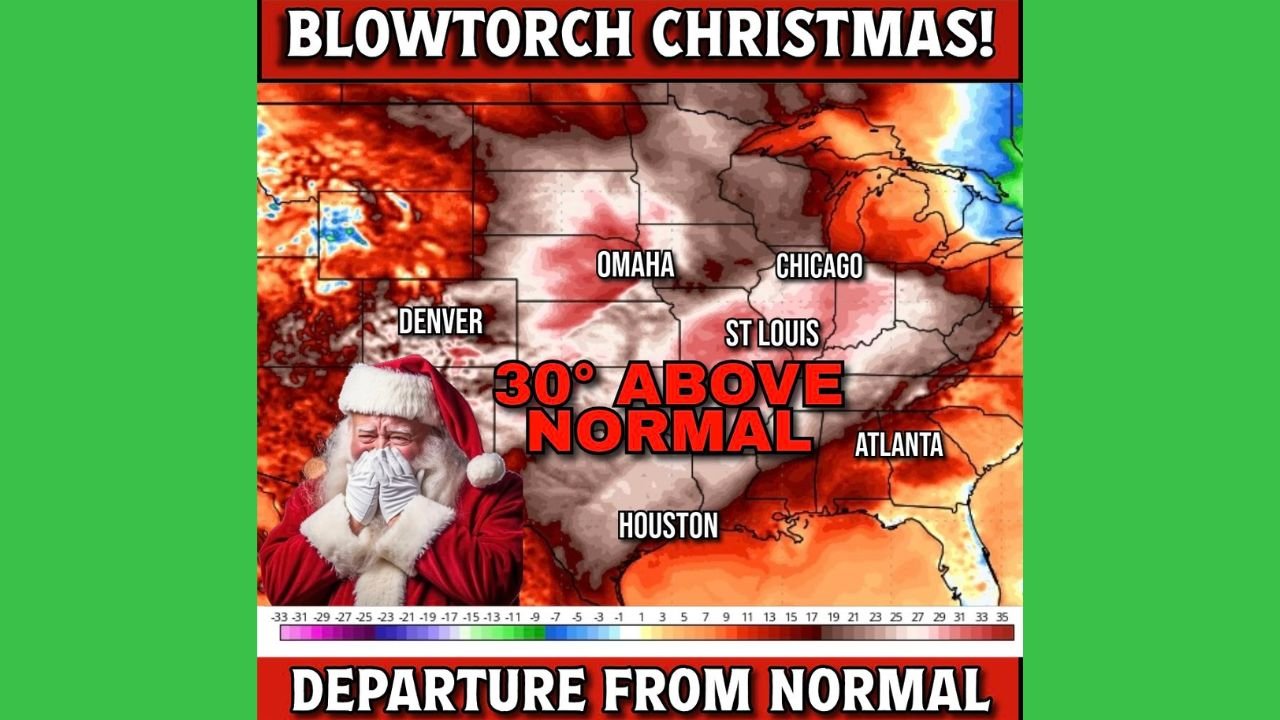
OMAHA, NEBRASKA — Forecast models are signaling a potentially historic warm spell around Christmas Day, with a large heat dome expected to drive temperatures 30 to 40 degrees above normal across the central United States, according to long-range temperature anomaly data.
While confidence will continue to evolve with the holiday still more than a week away, the latest guidance shows much of the nation’s middle experiencing an unusually warm Christmas, leaving only a few regions spared from the abnormal heat.
What the Christmas Temperature Anomaly Maps Are Showing
The temperature anomaly maps indicate a broad swath of deep red shading across the Plains and Midwest, a signal of exceptional warmth for late December.
Cities across:
- Texas
- Nebraska
- Missouri
- Illinois
- Kansas
- Iowa
- Arkansas
are currently projected to run well above climatological averages, with some areas exceeding 30°F above normal if the pattern verifies.
The strongest warmth is centered across the central Plains and Mississippi Valley, where December typically brings sustained cold.
Why Meteorologists Are Calling It a “Blowtorch” Setup
Meteorologists are using the term “blowtorch” to describe the strength and geographic size of the warm air mass, not necessarily because record highs are guaranteed everywhere.
A persistent upper-level ridge is forecast to park over the middle of the country, allowing mild Pacific air to surge northward while blocking Arctic air from dropping south.
“This is a classic holiday warm-ridge pattern, where winter cold gets pushed to the edges of the map.”
Which Areas May Escape the Worst of the Warmth
The anomaly maps suggest that not everyone will feel the heat.
Regions more likely to avoid the strongest warmth include:
- The Pacific Northwest
- The Northeast
- Portions of the Great Lakes
These areas remain closer to seasonal temperatures, with some even staying slightly below normal depending on how the ridge evolves.
What This Means for a Traditional White Christmas
A warm Christmas across the central U.S. would significantly reduce the odds of snow cover in many locations that normally rely on cold air persistence.
Snowpack across the Plains and Midwest could melt rapidly, while areas farther north and east retain winter conditions.
This pattern also favors:
- Rain instead of snow in marginal areas
- Muddy ground conditions
- Reduced holiday travel hazards from winter storms
Still Time for Changes Before Christmas
Forecasters stress that this outlook is still nine days away, and adjustments to the strength or placement of the ridge remain possible.
A shift east or west could:
- Reduce the warmth in some states
- Increase it in others
- Allow colder air to briefly return
“This is a strong signal, but not a locked-in forecast yet.”
Bottom Line
- Central U.S. likely much warmer than normal on Christmas
- 30–40°F positive anomalies possible in parts of the Plains and Midwest
- Edges of the country more likely to stay seasonal
- Forecast still evolving, but warmth is the dominant signal
WaldronNews.com will continue tracking updates to this Christmas forecast as newer model runs arrive and confidence increases.