
White Christmas Still Possible Across New York, Pennsylvania, Massachusetts, and New England as Late-Week Storm Signals Rain, Cold, and Potential Snow Before Christmas
NEW YORK, NEW YORK — A shifting late-December weather pattern is raising renewed questions about a possible White Christmas across parts of the Northeast, even as rain arrives first and colder air follows closely behind. Forecast data shows a strong cold frontal passage Thursday, setting the stage for sharply falling temperatures and a potential transition toward wintry conditions as Christmas approaches.
Meteorologists caution that the forecast remains highly fluid, but model guidance continues to hint at a meaningful winter weather signal between December 23 and December 25, especially for inland and northern areas of the Northeast.
Rain Arrives First as Strong Cold Front Pushes East
Weather models indicate rain moving into the Northeast on Thursday, driven by a fast-moving storm system and a strong cold front. This initial wave is expected to bring wet conditions rather than snow, particularly along the Interstate 95 corridor from New Jersey through New York City and into southern New England.
Behind the rain, however, colder air is expected to surge southward.
“Temperatures will drop rather dramatically behind the rain,” forecasters note, highlighting the sharp contrast expected once the front passes.
Colder Air Opens the Door for Wintry Weather
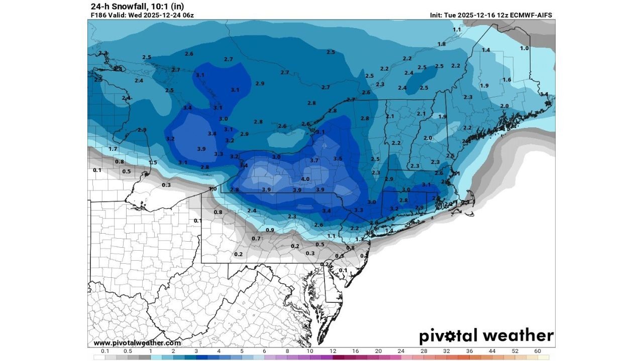
As colder air filters in late Thursday and Friday, attention turns toward the days leading into Christmas Eve and Christmas Day. Updated ECMWF-AIFS model data suggests that snowfall could develop as colder air deepens, particularly north and west of major cities.
Current projections show:
- Higher snow potential across upstate New York, northern Pennsylvania, interior New England, and higher elevations
- Lower totals closer to the coast, where rain may linger longer before temperatures fall
While exact amounts remain uncertain, the model imagery shows a broad swath of light to moderate snowfall potential, enough to support at least a partial White Christmas in many inland locations if trends hold.
Why Forecast Confidence Is Still Limited
Meteorologists stress that these snowfall projections are preliminary. The storm’s timing has already shifted in recent model runs, arriving slightly faster than earlier forecasts, which affects how quickly colder air can lock in.
“These numbers are absolutely going to change,” forecasters emphasize, noting that small track or timing changes could dramatically alter snowfall outcomes.
At this range, confidence is higher in colder conditions than in specific snowfall totals.
What to Expect Christmas Week
Based on the latest data:
- Thursday: Rain moves in with a strong cold front
- Friday into the weekend: Colder, more seasonal air settles in
- Dec. 23–25: Increasing signals for wintry weather, especially inland
Even if snow does not reach coastal cities, many northern and interior areas still have a realistic chance of seeing snow on the ground by Christmas morning.
Bottom Line for Holiday Travel and Planning
Travelers should prepare for changing conditions late this week, including:
- Wet roads followed by rapid cooling
- Potential icy spots where temperatures drop quickly
- Increasing snow chances inland as Christmas nears
Forecast updates over the next several days will be critical as meteorologists refine the storm’s timing and cold air placement.
For continued weather updates and local impacts as the holiday forecast evolves, stay connected with WaldronNews.com.